

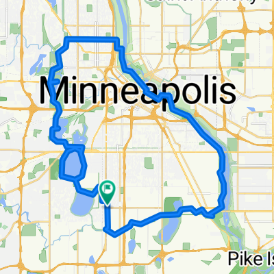
B2B00382 55423 > 55407 via 12th, 15th, Bloomington
Trasa rowerowa rozpoczynająca się w Richfield, Minnesota, USA.
Przegląd
O tej trasie
Take 69th east to 12th Ave.
Left onto 12th Ave, and take 12th Ave north to 64th St.
Right onto 64th to Bloomington.
Left on Bloomington, and bike alongside the park heading north.
At the edge of the park, a bridge will appear to your left.
Take bridge over 62. Once over the bridge, hang a left onto 60th St.
Go right onto 12th Ave, and continue on 12th up to 47th.
Take a right onto 47th St and take that to 15th Ave.
Take a left onto 15th and take it to 32nd St.
Take a left onto 32nd, a quick right onto 14th Ave, and a left onto Powderhorn Terrace.
Powderhorn Terrace will curve to the right (curve north) and become 12th Ave.
Take that one block to 31st St, and take a left.
Take 31st St west to Park Ave. (note: on the way to Park, you'll cross Chicago where 1st juts slightly to the right, but keep heading west on 31st west).
Take a right onto Park and take the bikelane north to 28th.
Take a right on 28th and head a couple blocks to destination. (note, 28th St is one-way, and occasionally has a lot of traffic. An alternative is to walk the last 2 blocks on the sidewalk).
- -:--
- Czas
- 11,3 km
- Dystans
- 34 m
- Przewyższenia
- 28 m
- Spadek
- ---
- Śr. Prędkość
- 264 m
- Maks. wysokość
Jakość trasy
Typy dróg i nawierzchnie na trasie
Typy dróg
Spokojna droga
7,5 km
(67 %)
Droga
2,3 km
(20 %)
Powierzchnie
Utwardzona
1,9 km
(17 %)
Asfalt
1,9 km
(17 %)
Niezdefiniowany
9,3 km
(83 %)
Kontynuuj z Bikemap
Użyj, edytuj lub pobierz tę trasę rowerową
Chcesz przejechać trasę B2B00382 55423 > 55407 via 12th, 15th, Bloomington lub dostosować ją do swojej wycieczki? Oto, co możesz zrobić z tą trasą na Bikemap:
Darmowe funkcje
- Zapisz tę trasę jako ulubioną lub w kolekcji
- Skopiuj i zaplanuj swoją wersję tej trasy
- Synchronizuj swoją trasę z Garminem lub Wahoo
Funkcje Premium
3 dni bezpłatnej wersji próbnej lub jednorazowa opłata. Dowiedz się więcej o Bikemap Premium.
- Nawiguj po tej trasie na iOS i Androidzie
- Eksportuj plik GPX / KML tej trasy
- Stwórz swój własny wydruk (wypróbuj za darmo)
- Pobierz tę trasę do nawigacji offline
Odkryj więcej funkcji Premium.
Uzyskaj Bikemap PremiumOd naszej społeczności
Richfield: Inne popularne trasy rozpoczynające się tutaj
 MoA - Grand Route - MoA
- Dystans
- 61,9 km
- Przewyższenia
- 156 m
- Spadek
- 158 m
- Lokalizacja
- Richfield, Minnesota, USA
 B2B00920 55407>55438 via Portland, Mnnha Pwy, Logan, Hylund Prk
- Dystans
- 23,7 km
- Przewyższenia
- 98 m
- Spadek
- 95 m
- Lokalizacja
- Richfield, Minnesota, USA
 B2B00114 55409 >55414 via Park Ave and stone arch bridge
- Dystans
- 9 km
- Przewyższenia
- 48 m
- Spadek
- 57 m
- Lokalizacja
- Richfield, Minnesota, USA
 the Bike & Bistro's premiere tour
- Dystans
- 6,7 km
- Przewyższenia
- 26 m
- Spadek
- 9 m
- Lokalizacja
- Richfield, Minnesota, USA
 Day 1 Lag 3
- Dystans
- 106,3 km
- Przewyższenia
- 327 m
- Spadek
- 359 m
- Lokalizacja
- Richfield, Minnesota, USA
 East 46th Street 180, Minneapolis to Union Depot, Saint Paul
- Dystans
- 22,2 km
- Przewyższenia
- 153 m
- Spadek
- 185 m
- Lokalizacja
- Richfield, Minnesota, USA
 30 miler
- Dystans
- 48,5 km
- Przewyższenia
- 308 m
- Spadek
- 310 m
- Lokalizacja
- Richfield, Minnesota, USA
 B2B00042 55419 > 55422 via Greenway, Cedar Lake, and Theo Wirth
- Dystans
- 13,3 km
- Przewyższenia
- 61 m
- Spadek
- 59 m
- Lokalizacja
- Richfield, Minnesota, USA
Otwórz ją w aplikacji