B2B00348 55417 > 55401 via Minnehaha
Trasa rowerowa rozpoczynająca się w Richfield, Minnesota, USA.
Przegląd
O tej trasie
-
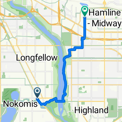
Take 38th Ave north to 54th St.
-
Take a right onto 54th St and cross Hiawatha.
Take a left onto Minnehaha Parkway.
-
Take Minnehaha Ave's bike lane northwest to Lake Street.
-
Cross Lake Street as Minnehaha Ave changes to 26th Ave S and continue north to 26th Street.
At this point you can either continue on 26th all the way through to Riverside and 26th. 26th is safe, but there is no bike lane. The route that is mapped is on more bike paths, as follows
-
Take a left onto 26th St. and look for the light rail trail bike path (which appears right before Hiawatha Ave).
-
Take a right onto the trail, and follow the path until it ends at 11th Avenue.
7. Take a left onto 11th, and follow the bike lane to 5th St.
8. Take a right onto 5th street. (note: 5th St is without a bike lane but traffic should be manageable. Also, veer to the left of the LRT once given the option to choose a side of the tracks).
9. Take 5th up to Marquette, and take a right into the bike lane.
10. Take Marquette to 4th St and your destination.
- -:--
- Czas
- 13 km
- Dystans
- 16 m
- Przewyższenia
- 14 m
- Spadek
- ---
- Śr. Prędkość
- 258 m
- Maks. wysokość
Jakość trasy
Typy dróg i nawierzchnie na trasie
Typy dróg
Spokojna droga
4,5 km
(35 %)
Droga rowerowa
3,1 km
(24 %)
Powierzchnie
Utwardzona
7 km
(54 %)
Asfalt
5,4 km
(42 %)
Nawierzchnia (nieokreślona)
1 km
(8 %)
Kontynuuj z Bikemap
Użyj, edytuj lub pobierz tę trasę rowerową
Chcesz przejechać trasę B2B00348 55417 > 55401 via Minnehaha lub dostosować ją do swojej wycieczki? Oto, co możesz zrobić z tą trasą na Bikemap:
Darmowe funkcje
- Zapisz tę trasę jako ulubioną lub w kolekcji
- Skopiuj i zaplanuj swoją wersję tej trasy
- Synchronizuj swoją trasę z Garminem lub Wahoo
Funkcje Premium
3 dni bezpłatnej wersji próbnej lub jednorazowa opłata. Dowiedz się więcej o Bikemap Premium.
- Nawiguj po tej trasie na iOS i Androidzie
- Eksportuj plik GPX / KML tej trasy
- Stwórz swój własny wydruk (wypróbuj za darmo)
- Pobierz tę trasę do nawigacji offline
Odkryj więcej funkcji Premium.
Uzyskaj Bikemap PremiumOd naszej społeczności
Richfield: Inne popularne trasy rozpoczynające się tutaj
- B2B00114 55409 >55414 via Park Ave and stone arch bridge
- Dystans
- 9 km
- Przewyższenia
- 48 m
- Spadek
- 57 m
- Lokalizacja
- Richfield, Minnesota, USA
- 31 Miles South to North, to Victory Memorial & Minnehaha
- Dystans
- 50,9 km
- Przewyższenia
- 124 m
- Spadek
- 124 m
- Lokalizacja
- Richfield, Minnesota, USA
- East 46th Street 180, Minneapolis to Union Depot, Saint Paul
- Dystans
- 22,2 km
- Przewyższenia
- 153 m
- Spadek
- 185 m
- Lokalizacja
- Richfield, Minnesota, USA
- Perfect Circle Minneapolis Bike Route
- Dystans
- 36,4 km
- Przewyższenia
- 117 m
- Spadek
- 117 m
- Lokalizacja
- Richfield, Minnesota, USA
- MoA - Grand Route - MoA
- Dystans
- 61,9 km
- Przewyższenia
- 156 m
- Spadek
- 158 m
- Lokalizacja
- Richfield, Minnesota, USA
- the Bike & Bistro's premiere tour
- Dystans
- 6,7 km
- Przewyższenia
- 26 m
- Spadek
- 9 m
- Lokalizacja
- Richfield, Minnesota, USA
- B2B00920 55407>55438 via Portland, Mnnha Pwy, Logan, Hylund Prk
- Dystans
- 23,7 km
- Przewyższenia
- 98 m
- Spadek
- 95 m
- Lokalizacja
- Richfield, Minnesota, USA
- B2B00001 55419 > 55416 via Lake Harriet, 38th, France
- Dystans
- 8,4 km
- Przewyższenia
- 75 m
- Spadek
- 76 m
- Lokalizacja
- Richfield, Minnesota, USA
Otwórz ją w aplikacji