

Rundfahrt Valpolicella 1 / Negar
Trasa rowerowa rozpoczynająca się w Arbizzano-Santa Maria, Veneto, Italy.
Przegląd
O tej trasie
Die Route führt höhenwegartig um die Gemeinde Negrar. Sie führt auf Höhenwege, zwischen Rebberge und auch an Orten mit einer tollen Aussicht. Es gibt gute Möglichkeiten, um die Route zu kürzen oder zu verlängern, je nach Kondition und Laune.
Beschreibung: In St. Maria gibt es gute Parkmöglichkeiten. Danach fährt man auf der Hauptstrasse ca. 1 km nach Pedemonte, um anschliessend über den reizvollen und teils bepflasterten Höhenweg bis zur Abzweigung nach Valgatara zu fahren. Hier ist ein MTB eindeutig von Vorteil. Kurz vor Marano die Valpolicella entscheidet man sich für den unbefestigten Weg (rechts abzweigen) oder für die Variante mit Zwischenhalt in Marano (auf der befestigten Strasse bleiben). Zwischen Ca'Camporal und Turbe lohnt sich der schönen Aussicht wegen ein kurzer Zwischenhalt. Nach dem Erreichen des höchsten Punktes ob Fane gilt es nach kurzer Abfahrt und dem Geniessen der Aussicht nach Lugo die Abzweigung rechts nicht zu verpassen. Weitere Stellen mit einer tollen Aussicht sind in Collombare die Villa und in Dondole. Nach Dondole geht es ziemlich steil, aber auf befestigter Strasse, runter nach Nagrar und zurück nach Santa Maria.
Hinweis: Die Route kann auch umgekehrt gefahren werden. Als grosse Herausforderung gilt im diesen Fall der Anstieg zwischen Siresol und Dondole, welcher konditionell einiges abverlangt.
- -:--
- Czas
- 37,9 km
- Dystans
- 888 m
- Przewyższenia
- 888 m
- Spadek
- ---
- Śr. Prędkość
- ---
- Maks. wysokość

Zdjęcia trasy


Jakość trasy
Typy dróg i nawierzchnie na trasie
Typy dróg
Spokojna droga
15,9 km
(42 %)
Droga
14,5 km
(38 %)
Powierzchnie
Utwardzona
33 km
(87 %)
Nieutwardzona
2,2 km
(6 %)
Asfalt
32,5 km
(86 %)
Otoczaki
1,6 km
(4 %)
Najważniejsze punkty trasy
Punkty zainteresowania na trasie
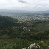
Zdjęcie po 14,1 km
Aussichtspunkt 1
Zdjęcie po 22,6 km
Aussichtspunkt
Zdjęcie po 26,2 km
Aussichtspunkt 2
Kontynuuj z Bikemap
Użyj, edytuj lub pobierz tę trasę rowerową
Chcesz przejechać trasę Rundfahrt Valpolicella 1 / Negar lub dostosować ją do swojej wycieczki? Oto, co możesz zrobić z tą trasą na Bikemap:
Darmowe funkcje
- Zapisz tę trasę jako ulubioną lub w kolekcji
- Skopiuj i zaplanuj swoją wersję tej trasy
- Synchronizuj swoją trasę z Garminem lub Wahoo
Funkcje Premium
3 dni bezpłatnej wersji próbnej lub jednorazowa opłata. Dowiedz się więcej o Bikemap Premium.
- Nawiguj po tej trasie na iOS i Androidzie
- Eksportuj plik GPX / KML tej trasy
- Stwórz swój własny wydruk (wypróbuj za darmo)
- Pobierz tę trasę do nawigacji offline
Odkryj więcej funkcji Premium.
Uzyskaj Bikemap PremiumOd naszej społeczności
Arbizzano-Santa Maria: Inne popularne trasy rozpoczynające się tutaj
 Promo Valpolicella Tour
- Dystans
- 18,2 km
- Przewyższenia
- 198 m
- Spadek
- 196 m
- Lokalizacja
- Arbizzano-Santa Maria, Veneto, Italy
 Percorso recente giro Valpolicella
- Dystans
- 31,7 km
- Przewyższenia
- 220 m
- Spadek
- 218 m
- Lokalizacja
- Arbizzano-Santa Maria, Veneto, Italy
 Cla Valpolicella 4
- Dystans
- 43,3 km
- Przewyższenia
- 950 m
- Spadek
- 950 m
- Lokalizacja
- Arbizzano-Santa Maria, Veneto, Italy
 Anello Valpolicella 2
- Dystans
- 32,3 km
- Przewyższenia
- 453 m
- Spadek
- 452 m
- Lokalizacja
- Arbizzano-Santa Maria, Veneto, Italy
 percorso 29 apr 23
- Dystans
- 29,9 km
- Przewyższenia
- 244 m
- Spadek
- 242 m
- Lokalizacja
- Arbizzano-Santa Maria, Veneto, Italy
 Anello Arbizzano - Peschiera - Arbizzano
- Dystans
- 60,1 km
- Przewyższenia
- 487 m
- Spadek
- 489 m
- Lokalizacja
- Arbizzano-Santa Maria, Veneto, Italy
 Cla Verona e bassa Valpolicella
- Dystans
- 28,2 km
- Przewyższenia
- 100 m
- Spadek
- 99 m
- Lokalizacja
- Arbizzano-Santa Maria, Veneto, Italy
 Rundfahrt Valpolicella 1 / Negar
- Dystans
- 37,9 km
- Przewyższenia
- 888 m
- Spadek
- 888 m
- Lokalizacja
- Arbizzano-Santa Maria, Veneto, Italy
Otwórz ją w aplikacji