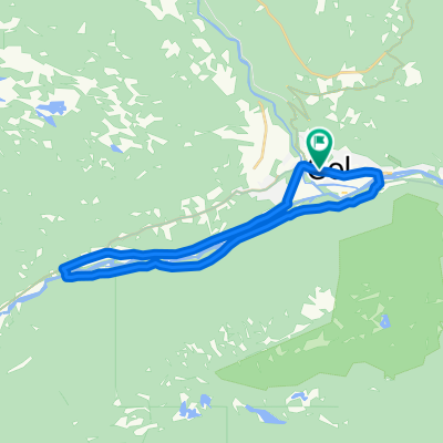
Einarsetrunden 14km
- 13,8 km
- 256 m
- 261 m
- Gol, Buskerud fylke, Norwegia
Trasa rowerowa rozpoczynająca się w Gol, Buskerud fylke, Norwegia.
Przegląd
Hallingrittet is a 45 km long bike ride at Golsfjellet in Hallingdal. This trip description is a bit shorter, because some parts of the ride goes both ways on the same road.
This description starts at Gurisetkrysset (crossroad) in the direction of Guriset Høyfjellshotell through Støsdokki. Follow the old Guriset road, which is a medium challenging carriage road, pass Flataskørtjedne and Auenhaugen to Lauvsetkrysset (crossroad). Then pass the Lauvsjøstølen (mountain farm) and follow the old Hjartingstølvegen (carriage road) along Lauvsjøstølen to the main road, and continue to Lauvset.
From Lauvset to Storefjell via Løstegård, Vermeli, Skutuset and Rekkjeset. Between Vermeli and Skutuset there is about 1 km with path/tractor road, but the rest of the road is good gravel road. Follow the marked path and road to Kamben and then continue back to Golsfjell road, pass Ørterstølen and back to Gurisetkrysset (crossroad).
Difficulty: MediumPossibility for bike trolley: NoService: Storefjell, Kamben, Ørterstølen, OsetLowest/highest point: 850/1049 m. Total climbing: 615 m
Have a nice trip!
utworzono 15 lat temu temu
Jakość trasy
Spokojna droga
25 km
(74 %)
Droga leśna
4,1 km
(12 %)
Nieutwardzona
23 km
(68 %)
Żwir
21,6 km
(64 %)
Luźny żwir
1,4 km
(4 %)
Niezdefiniowany
10,8 km
(32 %)
Kontynuuj z Bikemap
Chcesz przejechać trasę Hallingrittet lub dostosować ją do swojej wycieczki? Oto, co możesz zrobić z tą trasą na Bikemap:
3 dni bezpłatnej wersji próbnej lub jednorazowa opłata. Dowiedz się więcej o Bikemap Premium.
Odkryj więcej funkcji Premium.
Uzyskaj Bikemap PremiumOd naszej społeczności
Otwórz ją w aplikacji