
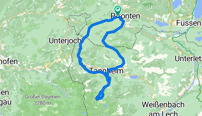
Pfronten - Schattwald - Tannheim (Höhenweg) - Vilsalpsee - Grän - Pfronten
Trasa rowerowa rozpoczynająca się w Pfronten, Bawaria, Niemcy.
Przegląd
O tej trasie
- 3 h 53 min
- Czas
- 47,2 km
- Dystans
- 474 m
- Przewyższenia
- 483 m
- Spadek
- 12,1 km/h
- Śr. Prędkość
- ---
- Maks. wysokość
Zdjęcia trasy
 - Vilsalpsee - Grän - Pfronten”")
 - Vilsalpsee - Grän - Pfronten”")
 - Vilsalpsee - Grän - Pfronten”")
 - Vilsalpsee - Grän - Pfronten”")
Kontynuuj z Bikemap
Użyj, edytuj lub pobierz tę trasę rowerową
Chcesz przejechać trasę Pfronten - Schattwald - Tannheim (Höhenweg) - Vilsalpsee - Grän - Pfronten lub dostosować ją do swojej wycieczki? Oto, co możesz zrobić z tą trasą na Bikemap:
Darmowe funkcje
- Zapisz tę trasę jako ulubioną lub w kolekcji
- Skopiuj i zaplanuj swoją wersję tej trasy
- Synchronizuj swoją trasę z Garminem lub Wahoo
Funkcje Premium
3 dni bezpłatnej wersji próbnej lub jednorazowa opłata. Dowiedz się więcej o Bikemap Premium.
- Nawiguj po tej trasie na iOS i Androidzie
- Eksportuj plik GPX / KML tej trasy
- Stwórz swój własny wydruk (wypróbuj za darmo)
- Pobierz tę trasę do nawigacji offline
Odkryj więcej funkcji Premium.
Uzyskaj Bikemap PremiumOd naszej społeczności
Pfronten: Inne popularne trasy rozpoczynające się tutaj
 Tages-Biketour(MTB)
- Dystans
- 55,8 km
- Przewyższenia
- 1886 m
- Spadek
- 1886 m
- Lokalizacja
- Pfronten, Bawaria, Niemcy
 Breitenbergrunde
- Dystans
- 20 km
- Przewyższenia
- 909 m
- Spadek
- 909 m
- Lokalizacja
- Pfronten, Bawaria, Niemcy
 Pfronten - Schattwald - Tannheim (Höhenweg) - Vilsalpsee - Grän - Pfronten
- Dystans
- 47,2 km
- Przewyższenia
- 474 m
- Spadek
- 483 m
- Lokalizacja
- Pfronten, Bawaria, Niemcy
 Alpencross Pfronten - Bardolino
- Dystans
- 372,3 km
- Przewyższenia
- 2741 m
- Spadek
- 3517 m
- Lokalizacja
- Pfronten, Bawaria, Niemcy
 All9: Pfronten - Irsee; 68,3km 500hm
- Dystans
- 68,3 km
- Przewyższenia
- 661 m
- Spadek
- 824 m
- Lokalizacja
- Pfronten, Bawaria, Niemcy
 Breitenberg Achtal
- Dystans
- 23,8 km
- Przewyższenia
- 849 m
- Spadek
- 850 m
- Lokalizacja
- Pfronten, Bawaria, Niemcy
 Um den Breitenberg
- Dystans
- 20,5 km
- Przewyższenia
- 903 m
- Spadek
- 684 m
- Lokalizacja
- Pfronten, Bawaria, Niemcy
 All9aSüd: Pfronten - Westendorf; 74,5km 390hm
- Dystans
- 74,5 km
- Przewyższenia
- 544 m
- Spadek
- 761 m
- Lokalizacja
- Pfronten, Bawaria, Niemcy
Otwórz ją w aplikacji