

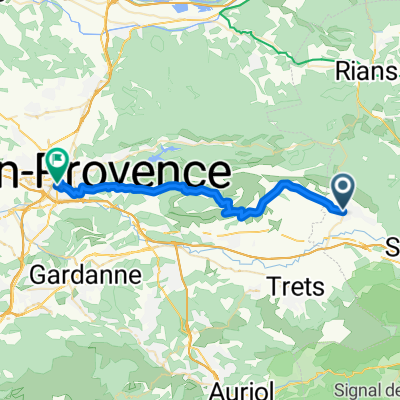
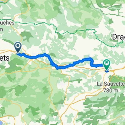
Pourrieres-rians-varages-st maximin-trets-Pourrières
Trasa rowerowa rozpoczynająca się w Pourrières, Prowansja-Alpy-Lazurowe Wybrzeże, Francja.
Przegląd
O tej trasie
route vallonée et sinueuse de Pourrières à Varages et Brue-Auriac puis faux plats et lignes droites jusqu' à Pourrières en passant par st Maximin et Trets.
- -:--
- Czas
- 77 km
- Dystans
- 605 m
- Przewyższenia
- 605 m
- Spadek
- ---
- Śr. Prędkość
- ---
- Maks. wysokość
Jakość trasy
Typy dróg i nawierzchnie na trasie
Typy dróg
Ruchliwa droga
49,3 km
(64 %)
Spokojna droga
14,8 km
(19 %)
Powierzchnie
Utwardzona
42,7 km
(55 %)
Nieutwardzona
2,3 km
(3 %)
Asfalt
42,7 km
(55 %)
Nieutwardzony (nieokreślony)
0,9 km
(1 %)
Kontynuuj z Bikemap
Użyj, edytuj lub pobierz tę trasę rowerową
Chcesz przejechać trasę Pourrieres-rians-varages-st maximin-trets-Pourrières lub dostosować ją do swojej wycieczki? Oto, co możesz zrobić z tą trasą na Bikemap:
Darmowe funkcje
- Zapisz tę trasę jako ulubioną lub w kolekcji
- Skopiuj i zaplanuj swoją wersję tej trasy
- Synchronizuj swoją trasę z Garminem lub Wahoo
Funkcje Premium
3 dni bezpłatnej wersji próbnej lub jednorazowa opłata. Dowiedz się więcej o Bikemap Premium.
- Nawiguj po tej trasie na iOS i Androidzie
- Eksportuj plik GPX / KML tej trasy
- Stwórz swój własny wydruk (wypróbuj za darmo)
- Pobierz tę trasę do nawigacji offline
Odkryj więcej funkcji Premium.
Uzyskaj Bikemap PremiumOd naszej społeczności
Pourrières: Inne popularne trasy rozpoczynające się tutaj
 Charlytest
- Dystans
- 31,4 km
- Przewyższenia
- 407 m
- Spadek
- 525 m
- Lokalizacja
- Pourrières, Prowansja-Alpy-Lazurowe Wybrzeże, Francja
 Lost Water Bottle Ride
- Dystans
- 26,8 km
- Przewyższenia
- 373 m
- Spadek
- 378 m
- Lokalizacja
- Pourrières, Prowansja-Alpy-Lazurowe Wybrzeże, Francja
 Pourrières à D 6, Pourrières
- Dystans
- 1,1 km
- Przewyższenia
- 16 m
- Spadek
- 35 m
- Lokalizacja
- Pourrières, Prowansja-Alpy-Lazurowe Wybrzeże, Francja
 37- contrastes à pourrieres
- Dystans
- 22,2 km
- Przewyższenia
- 347 m
- Spadek
- 347 m
- Lokalizacja
- Pourrières, Prowansja-Alpy-Lazurowe Wybrzeże, Francja
 D 623, Pourrières à 365E Chemin de Belle Vue, Pourrières
- Dystans
- 29,3 km
- Przewyższenia
- 436 m
- Spadek
- 405 m
- Lokalizacja
- Pourrières, Prowansja-Alpy-Lazurowe Wybrzeże, Francja
 1 Rue Marius Bourrelly, Pourcieux to 5 Avenue Pierre Gaudin, Le Luc
- Dystans
- 58,6 km
- Przewyższenia
- 674 m
- Spadek
- 860 m
- Lokalizacja
- Pourrières, Prowansja-Alpy-Lazurowe Wybrzeże, Francja
 Monext : Ironman Pays d'Aix Part 2
- Dystans
- 31,2 km
- Przewyższenia
- 424 m
- Spadek
- 543 m
- Lokalizacja
- Pourrières, Prowansja-Alpy-Lazurowe Wybrzeże, Francja
 Mont Sainte Victoire
- Dystans
- 63,6 km
- Przewyższenia
- 879 m
- Spadek
- 878 m
- Lokalizacja
- Pourrières, Prowansja-Alpy-Lazurowe Wybrzeże, Francja
Otwórz ją w aplikacji