

B2B00439 55406 > 55402 via Minnehaha, LRT trail, 11th
Trasa rowerowa rozpoczynająca się w Richfield, Minnesota, USA.
Przegląd
O tej trasie
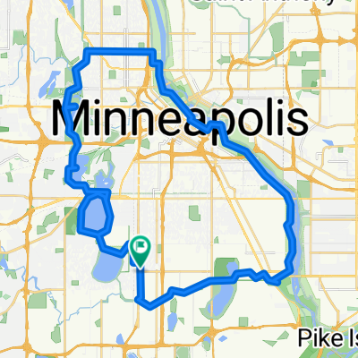
- Take 45th St west to Minnehaha Pkwy
2. Take a right onto Minnehaha Parkway.
-
Take Minnehaha Ave's bike lane northwest to Lake Street.
-
Cross Lake Street as Minnehaha Ave changes to 26th Ave S and continue north to 26th Street.
-
Take a left onto 26th St. and look for the light rail trail bike path (which appears right before Hiawatha Ave).
-
Take a right onto the trail, and follow the path until it ends at 11th Avenue.
7. Take a left onto 11th, and follow the bike lane to 5th St.
8. Take a right onto 5th street. (note: 5th St is without a bike lane but traffic should be manageable. Also, veer to the left of the LRT once given the option to choose a side of the tracks).
9. Take 5th up to Portland.
10. Take a left onto Portland into the bike lane and continue until you reach 9th.
11. Take a right into the bike lane on 9th, and head all the way to Nicollet Mall
- -:--
- Czas
- 9,1 km
- Dystans
- 5 m
- Przewyższenia
- 0 m
- Spadek
- ---
- Śr. Prędkość
- 257 m
- Maks. wysokość
Jakość trasy
Typy dróg i nawierzchnie na trasie
Typy dróg
Spokojna droga
2,6 km
(29 %)
Droga rowerowa
2,3 km
(25 %)
Powierzchnie
Utwardzona
5,6 km
(61 %)
Asfalt
4,7 km
(52 %)
Nawierzchnia (nieokreślona)
0,5 km
(5 %)
Kontynuuj z Bikemap
Użyj, edytuj lub pobierz tę trasę rowerową
Chcesz przejechać trasę B2B00439 55406 > 55402 via Minnehaha, LRT trail, 11th lub dostosować ją do swojej wycieczki? Oto, co możesz zrobić z tą trasą na Bikemap:
Darmowe funkcje
- Zapisz tę trasę jako ulubioną lub w kolekcji
- Skopiuj i zaplanuj swoją wersję tej trasy
- Synchronizuj swoją trasę z Garminem lub Wahoo
Funkcje Premium
3 dni bezpłatnej wersji próbnej lub jednorazowa opłata. Dowiedz się więcej o Bikemap Premium.
- Nawiguj po tej trasie na iOS i Androidzie
- Eksportuj plik GPX / KML tej trasy
- Stwórz swój własny wydruk (wypróbuj za darmo)
- Pobierz tę trasę do nawigacji offline
Odkryj więcej funkcji Premium.
Uzyskaj Bikemap PremiumOd naszej społeczności
Richfield: Inne popularne trasy rozpoczynające się tutaj
 30 miler
- Dystans
- 48,5 km
- Przewyższenia
- 308 m
- Spadek
- 310 m
- Lokalizacja
- Richfield, Minnesota, USA
 MoA - Grand Route - MoA
- Dystans
- 61,9 km
- Przewyższenia
- 156 m
- Spadek
- 158 m
- Lokalizacja
- Richfield, Minnesota, USA
 B2B00001 55419 > 55416 via Lake Harriet, 38th, France
- Dystans
- 8,4 km
- Przewyższenia
- 75 m
- Spadek
- 76 m
- Lokalizacja
- Richfield, Minnesota, USA
 Perfect Circle Minneapolis Bike Route
- Dystans
- 36,4 km
- Przewyższenia
- 117 m
- Spadek
- 117 m
- Lokalizacja
- Richfield, Minnesota, USA
 31 Miles South to North, to Victory Memorial & Minnehaha
- Dystans
- 50,9 km
- Przewyższenia
- 124 m
- Spadek
- 124 m
- Lokalizacja
- Richfield, Minnesota, USA
 the Bike & Bistro's premiere tour
- Dystans
- 6,7 km
- Przewyższenia
- 26 m
- Spadek
- 9 m
- Lokalizacja
- Richfield, Minnesota, USA
 B2B00042 55419 > 55422 via Greenway, Cedar Lake, and Theo Wirth
- Dystans
- 13,3 km
- Przewyższenia
- 61 m
- Spadek
- 59 m
- Lokalizacja
- Richfield, Minnesota, USA
 B2B00114 55409 >55414 via Park Ave and stone arch bridge
- Dystans
- 9 km
- Przewyższenia
- 48 m
- Spadek
- 57 m
- Lokalizacja
- Richfield, Minnesota, USA
Otwórz ją w aplikacji