

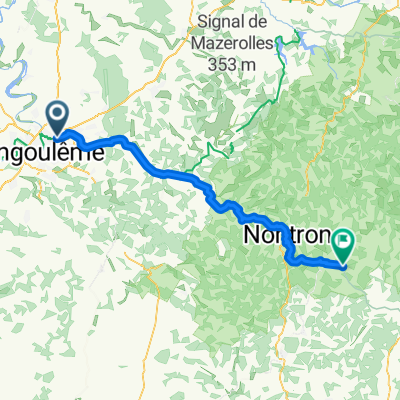
Tour de Base - Étape 8 (Saint-Yrieix-sur-Charente > Saint-Félix-de-Bourdeilles, via La Flow Vélo)
Trasa rowerowa rozpoczynająca się w Gond-Pontouvre, Nouvelle-Aquitaine, Francja.
Przegląd
O tej trasie
Saint-Yrieix-sur-Charente > Saint-Félix-de-Bourdeilles
Hébergement le soir au camping Domaine des Etangs du Plessac, Le Bourg, 24340 Saint-Félix-de-Bourdeilles 05 53 46 39 12
- -:--
- Czas
- 65,1 km
- Dystans
- 428 m
- Przewyższenia
- 302 m
- Spadek
- ---
- Śr. Prędkość
- ---
- Maks. wysokość
Jakość trasy
Typy dróg i nawierzchnie na trasie
Typy dróg
Spokojna droga
29,9 km
(46 %)
Droga rowerowa
22,5 km
(35 %)
Powierzchnie
Utwardzona
31,8 km
(49 %)
Nieutwardzona
4,6 km
(7 %)
Asfalt
31,8 km
(49 %)
Żwir
2,4 km
(4 %)
Kontynuuj z Bikemap
Użyj, edytuj lub pobierz tę trasę rowerową
Chcesz przejechać trasę Tour de Base - Étape 8 (Saint-Yrieix-sur-Charente > Saint-Félix-de-Bourdeilles, via La Flow Vélo) lub dostosować ją do swojej wycieczki? Oto, co możesz zrobić z tą trasą na Bikemap:
Darmowe funkcje
- Zapisz tę trasę jako ulubioną lub w kolekcji
- Skopiuj i zaplanuj swoją wersję tej trasy
- Synchronizuj swoją trasę z Garminem lub Wahoo
Funkcje Premium
3 dni bezpłatnej wersji próbnej lub jednorazowa opłata. Dowiedz się więcej o Bikemap Premium.
- Nawiguj po tej trasie na iOS i Androidzie
- Eksportuj plik GPX / KML tej trasy
- Stwórz swój własny wydruk (wypróbuj za darmo)
- Pobierz tę trasę do nawigacji offline
Odkryj więcej funkcji Premium.
Uzyskaj Bikemap PremiumOd naszej społeczności
Gond-Pontouvre: Inne popularne trasy rozpoczynające się tutaj
 Cha-Landak 1
- Dystans
- 34,5 km
- Przewyższenia
- 101 m
- Spadek
- 114 m
- Lokalizacja
- Gond-Pontouvre, Nouvelle-Aquitaine, Francja
 De Rue du Camping 1, Saint-Yrieix-sur-Charente à Impasse Chaussée des Moulins 3, Jarnac
- Dystans
- 42 km
- Przewyższenia
- 237 m
- Spadek
- 255 m
- Lokalizacja
- Gond-Pontouvre, Nouvelle-Aquitaine, Francja
 Tour de Base - Étape 8 (Saint-Yrieix-sur-Charente > Saint-Félix-de-Bourdeilles, via La Flow Vélo)
- Dystans
- 65,1 km
- Przewyższenia
- 428 m
- Spadek
- 302 m
- Lokalizacja
- Gond-Pontouvre, Nouvelle-Aquitaine, Francja
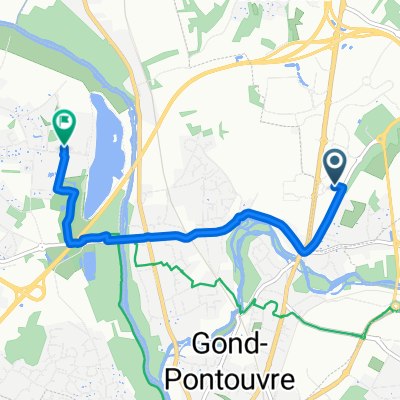
 268 Route de Vars, Gond-Pontouvre à 1 Rue de la Rivière, Gond-Pontouvre
- Dystans
- 19,3 km
- Przewyższenia
- 158 m
- Spadek
- 156 m
- Lokalizacja
- Gond-Pontouvre, Nouvelle-Aquitaine, Francja
 De Rue Alfred Leyssenot 39, Gond-Pontouvre à Rue Alfred Leyssenot 39, Gond-Pontouvre
- Dystans
- 22,5 km
- Przewyższenia
- 128 m
- Spadek
- 127 m
- Lokalizacja
- Gond-Pontouvre, Nouvelle-Aquitaine, Francja
 Gond-Pontouvre - Sent Pardol de la Ribiera
- Dystans
- 66,4 km
- Przewyższenia
- 725 m
- Spadek
- 582 m
- Lokalizacja
- Gond-Pontouvre, Nouvelle-Aquitaine, Francja
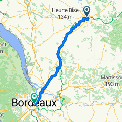 Bordeaux1
- Dystans
- 147,3 km
- Przewyższenia
- 869 m
- Spadek
- 893 m
- Lokalizacja
- Gond-Pontouvre, Nouvelle-Aquitaine, Francja
 Rue du Linteau, Champniers nach Rue du Camping, Saint-Yrieix-sur-Charente
- Dystans
- 4,9 km
- Przewyższenia
- 39 m
- Spadek
- 81 m
- Lokalizacja
- Gond-Pontouvre, Nouvelle-Aquitaine, Francja
Otwórz ją w aplikacji