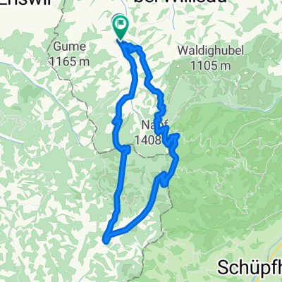
Scheidegg Tour
Trasa rowerowa rozpoczynająca się w Luthern, Lucerna, Szwajcaria.
Przegląd
O tej trasie
zum Bikehotel > www.kroneluthern.ch
Ta krótka trasa okrężna jest idealna na rower i flyer i można ją także pokonać w odwrotnym kierunku. Ci, którzy wolą trochę wygodniej na początku, powinni podążać za trasą w kierunku Luthernbad. Już wkrótce zacznie się wspinaczka na strefę wzgórz, która rozciąga się jak długa język do doliny, do Gross Scheidegg. Stamtąd prowadzi leśna droga przez Chessel do Müttebüel. Nie zdziwcie się, jeśli nagle zobaczycie z bardzo bliska kozice. Teraz na chwilę opuszczacie gminę Luthern i okrążacie wzgórze przez Hochschwändi i Buechighus, aby z powrotem dotrzeć do gminy Luthern przez Chatzerschwand. Teraz zaczyna się wspaniały zjazd z cudownym widokiem na Mittelland i łańcuch Jurajski, wracając do punktu wyjścia.
- -:--
- Czas
- 17,7 km
- Dystans
- 564 m
- Przewyższenia
- 559 m
- Spadek
- ---
- Śr. Prędkość
- ---
- Maks. wysokość
Jakość trasy
Typy dróg i nawierzchnie na trasie
Typy dróg
Droga leśna
12,4 km
(70 %)
Droga dojazdowa
3,7 km
(21 %)
Powierzchnie
Utwardzona
6,4 km
(36 %)
Nieutwardzona
5,5 km
(31 %)
Nawierzchnia (nieokreślona)
5,3 km
(30 %)
Żwir
2,3 km
(13 %)
Kontynuuj z Bikemap
Użyj, edytuj lub pobierz tę trasę rowerową
Chcesz przejechać trasę Scheidegg Tour lub dostosować ją do swojej wycieczki? Oto, co możesz zrobić z tą trasą na Bikemap:
Darmowe funkcje
- Zapisz tę trasę jako ulubioną lub w kolekcji
- Skopiuj i zaplanuj swoją wersję tej trasy
- Synchronizuj swoją trasę z Garminem lub Wahoo
Funkcje Premium
3 dni bezpłatnej wersji próbnej lub jednorazowa opłata. Dowiedz się więcej o Bikemap Premium.
- Nawiguj po tej trasie na iOS i Androidzie
- Eksportuj plik GPX / KML tej trasy
- Stwórz swój własny wydruk (wypróbuj za darmo)
- Pobierz tę trasę do nawigacji offline
Odkryj więcej funkcji Premium.
Uzyskaj Bikemap PremiumOd naszej społeczności
Luthern: Inne popularne trasy rozpoczynające się tutaj
 Napfrundfahrt
- Dystans
- 107 km
- Przewyższenia
- 897 m
- Spadek
- 897 m
- Lokalizacja
- Luthern, Lucerna, Szwajcaria
 Lüderenalp Tour
- Dystans
- 66,4 km
- Przewyższenia
- 1702 m
- Spadek
- 1702 m
- Lokalizacja
- Luthern, Lucerna, Szwajcaria
 Mettlen Tour
- Dystans
- 32,5 km
- Przewyższenia
- 880 m
- Spadek
- 875 m
- Lokalizacja
- Luthern, Lucerna, Szwajcaria
 Scheidegg, Napf, Luthern Bad, Chrutzi
- Dystans
- 18 km
- Przewyższenia
- 889 m
- Spadek
- 895 m
- Lokalizacja
- Luthern, Lucerna, Szwajcaria
 A04 Hergiswil Napf
- Dystans
- 25,8 km
- Przewyższenia
- 578 m
- Spadek
- 577 m
- Lokalizacja
- Luthern, Lucerna, Szwajcaria
 Oberlehn - Tour
- Dystans
- 38 km
- Przewyższenia
- 791 m
- Spadek
- 791 m
- Lokalizacja
- Luthern, Lucerna, Szwajcaria
 Änzi Tour
- Dystans
- 20,7 km
- Przewyższenia
- 639 m
- Spadek
- 636 m
- Lokalizacja
- Luthern, Lucerna, Szwajcaria
 Scheidegg Tour
- Dystans
- 17,7 km
- Przewyższenia
- 564 m
- Spadek
- 559 m
- Lokalizacja
- Luthern, Lucerna, Szwajcaria
Otwórz ją w aplikacji

