- 128,4 km
- 3364 m
- 3373 m
- Guillestre, Prowansja-Alpy-Lazurowe Wybrzeże, Francja
Yeehoo Trip
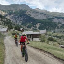
Trasa rowerowa rozpoczynająca się w Guillestre, Prowansja-Alpy-Lazurowe Wybrzeże, Francja.
Przegląd
O tej trasie
- -:--
- Czas
- 368,9 km
- Dystans
- 7959 m
- Przewyższenia
- 8522 m
- Spadek
- ---
- Śr. Prędkość
- ---
- Maks. wysokość
utworzono 15 lat temu temu
Najważniejsze punkty trasy
Punkty zainteresowania na trasie
Interesujące miejsce po 27,6 km
Casse Deserte
Interesujące miejsce po 29,9 km
Izoard
Interesujące miejsce po 78,9 km
Col du Galibier
Interesujące miejsce po 87,3 km
Col du Lautaret
Interesujące miejsce po 114,9 km
Lost of tunnels
Interesujące miejsce po 140,8 km
Alpe Huez
Interesujące miejsce po 150,5 km
quiet and scenic way down Alpe d'Huez
Interesujące miejsce po 169,1 km
terrific climb - 1st climb in La Marmotte
Interesujące miejsce po 185,2 km
Col de la Croix de Fer (only 2.5 kms easy pedaling as detour)
Interesujące miejsce po 186,2 km
Col du Glandon (1st km of this descent is the Frinking Picture)
Interesujące miejsce po 227,4 km
Col de la Madeleine
Interesujące miejsce po 268,6 km
Bike path
Interesujące miejsce po 274,2 km
From Albertville can take bike path - mainly flattish all the way to annecy (90% is no cars)
Interesujące miejsce po 298,4 km
Cormet de Roselend
Interesujące miejsce po 299,8 km
Col des saisies
Interesujące miejsce po 326,1 km
Col des Aravis
Interesujące miejsce po 350,2 km
Col de la Colombiere
Kontynuuj z Bikemap
Użyj, edytuj lub pobierz tę trasę rowerową
Chcesz przejechać trasę Yeehoo Trip lub dostosować ją do swojej wycieczki? Oto, co możesz zrobić z tą trasą na Bikemap:
Darmowe funkcje
- Zapisz tę trasę jako ulubioną lub w kolekcji
- Skopiuj i zaplanuj swoją wersję tej trasy
- Podziel trasę na etapy, aby utworzyć kilkudniową wycieczkę
- Synchronizuj swoją trasę z Garminem lub Wahoo
Funkcje Premium
3 dni bezpłatnej wersji próbnej lub jednorazowa opłata. Dowiedz się więcej o Bikemap Premium.
- Nawiguj po tej trasie na iOS i Androidzie
- Eksportuj plik GPX / KML tej trasy
- Stwórz swój własny wydruk (wypróbuj za darmo)
- Pobierz tę trasę do nawigacji offline
Odkryj więcej funkcji Premium.
Uzyskaj Bikemap PremiumOd naszej społeczności
Guillestre: Inne popularne trasy rozpoczynające się tutaj
- Vars - Bonette
- Ambitieuse Ceillac ++
- 26,9 km
- 708 m
- 708 m
- Guillestre, Prowansja-Alpy-Lazurowe Wybrzeże, Francja
- les fontaines enchantées,mont Dauphin
- 18,2 km
- 281 m
- 279 m
- Guillestre, Prowansja-Alpy-Lazurowe Wybrzeże, Francja
- Ambitieuse Arvieux
- 23,9 km
- 570 m
- 574 m
- Guillestre, Prowansja-Alpy-Lazurowe Wybrzeże, Francja
- BIKESHOP-EXP-GEB-Col de Larche
- 52,4 km
- 2114 m
- 1014 m
- Guillestre, Prowansja-Alpy-Lazurowe Wybrzeże, Francja
- CeillacRiailleCristillan(DuChalet)
- 51,2 km
- 1937 m
- 1936 m
- Guillestre, Prowansja-Alpy-Lazurowe Wybrzeże, Francja
- BIKESHOP-INT-GEB-Accès Fouran
- 8,9 km
- 553 m
- 41 m
- Guillestre, Prowansja-Alpy-Lazurowe Wybrzeże, Francja
- CeillacRiailleCristillan
- 62,4 km
- 1624 m
- 1624 m
- Guillestre, Prowansja-Alpy-Lazurowe Wybrzeże, Francja
Otwórz ją w aplikacji


