Höflinger Forst - Höhenhof Rundtour
Trasa rowerowa rozpoczynająca się w Obertraubling, Bawaria, Niemcy.
Przegląd
O tej trasie
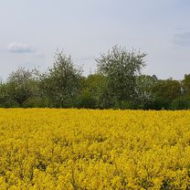
Wycieczka rowerowa MTB na południowy wschód od Ratyzbony. Świetna trasa dla miłośników relaksującej jazdy, ponieważ trasa jest malownicza. Czasami pojawiają się mniejsze szlaki, ale nic trudnego.
- -:--
- Czas
- 31,6 km
- Dystans
- 396 m
- Przewyższenia
- 400 m
- Spadek
- ---
- Śr. Prędkość
- 431 m
- Maks. wysokość
Zdjęcia trasy
Jakość trasy
Typy dróg i nawierzchnie na trasie
Typy dróg
Droga leśna
22,4 km
(71 %)
Droga dojazdowa
3,2 km
(10 %)
Powierzchnie
Utwardzona
3,8 km
(12 %)
Nieutwardzona
25,6 km
(81 %)
Żwir
17,4 km
(55 %)
Nieutwardzony (nieokreślony)
4,7 km
(15 %)
Kontynuuj z Bikemap
Użyj, edytuj lub pobierz tę trasę rowerową
Chcesz przejechać trasę Höflinger Forst - Höhenhof Rundtour lub dostosować ją do swojej wycieczki? Oto, co możesz zrobić z tą trasą na Bikemap:
Darmowe funkcje
- Zapisz tę trasę jako ulubioną lub w kolekcji
- Skopiuj i zaplanuj swoją wersję tej trasy
- Synchronizuj swoją trasę z Garminem lub Wahoo
Funkcje Premium
3 dni bezpłatnej wersji próbnej lub jednorazowa opłata. Dowiedz się więcej o Bikemap Premium.
- Nawiguj po tej trasie na iOS i Androidzie
- Eksportuj plik GPX / KML tej trasy
- Stwórz swój własny wydruk (wypróbuj za darmo)
- Pobierz tę trasę do nawigacji offline
Odkryj więcej funkcji Premium.
Uzyskaj Bikemap PremiumOd naszej społeczności
Obertraubling: Inne popularne trasy rozpoczynające się tutaj
 Regenpanoramatour
- Dystans
- 92,6 km
- Przewyższenia
- 714 m
- Spadek
- 711 m
- Lokalizacja
- Obertraubling, Bawaria, Niemcy
 Feng Shui Hohe-Linie Tour
- Dystans
- 38 km
- Przewyższenia
- 333 m
- Spadek
- 334 m
- Lokalizacja
- Obertraubling, Bawaria, Niemcy
 Höflinger Forst - Höhenhof Rundtour
- Dystans
- 31,6 km
- Przewyższenia
- 396 m
- Spadek
- 400 m
- Lokalizacja
- Obertraubling, Bawaria, Niemcy
 Obertraubling-Matting und zurück
- Dystans
- 32,5 km
- Przewyższenia
- 249 m
- Spadek
- 242 m
- Lokalizacja
- Obertraubling, Bawaria, Niemcy
 Regenpanoramatour
- Dystans
- 92,6 km
- Przewyższenia
- 699 m
- Spadek
- 700 m
- Lokalizacja
- Obertraubling, Bawaria, Niemcy
 Regenpanoramatour
- Dystans
- 92,6 km
- Przewyższenia
- 698 m
- Spadek
- 699 m
- Lokalizacja
- Obertraubling, Bawaria, Niemcy
 Obertraubling-Seppenhausen-Obertraubling
- Dystans
- 48,4 km
- Przewyższenia
- 50 m
- Spadek
- 50 m
- Lokalizacja
- Obertraubling, Bawaria, Niemcy
 Piesenkofen Richtung Thalmassing
- Dystans
- 19,5 km
- Przewyższenia
- 124 m
- Spadek
- 122 m
- Lokalizacja
- Obertraubling, Bawaria, Niemcy
Otwórz ją w aplikacji


