
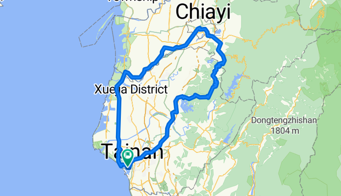
Two-day cycle: Tainan to Chiayi and back
Trasa rowerowa rozpoczynająca się w Tainan City, Taiwan, Taiwan.
Przegląd
O tej trasie
I completed this bicycle trip on the two days of a weekend: July 17-18, 2010. The first day of the journey was dull and uninspiring, a means to and end, that end being to get me to Chiayi from where I could spend the next day returning to Tainan via the foot-hill roads that run along the edges of the mountains behind WuShanTou Reservoir. Unfortunately I got myself a little bit sunburned on the way to Chiayi and so was paranoid about the skin damage getting any worse on the way back home. A mix of strategies reduced the potential harm of the ultra-violet radiation (including a small vial of SPF 50+ sunblock purchased from 7-11) and I arrived back at home in Tainan around 4:30 in the afternoon feeling weary but satisfied with my effort.
- -:--
- Czas
- 195,3 km
- Dystans
- 820 m
- Przewyższenia
- 817 m
- Spadek
- ---
- Śr. Prędkość
- ---
- Maks. wysokość

Jakość trasy
Typy dróg i nawierzchnie na trasie
Typy dróg
Ruchliwa droga
113,6 km
(58 %)
Droga dojazdowa
26,2 km
(13 %)
Powierzchnie
Utwardzona
30,9 km
(16 %)
Asfalt
30,6 km
(16 %)
Nawierzchnia (nieokreślona)
0,3 km
(<1 %)
Najważniejsze punkty trasy
Punkty zainteresowania na trasie
Nocleg po 85,1 km
I stopped for the night here at a hotel on Zhongzheng Rd. At NT$800 for the night it was pretty basic but good enough after a long day's cycle. That rate included a complimentary breakfast (again quite basic) although I had to skip it in order to get away early.
Interesujące miejsce po 102,8 km
The nicest part of the journey. I rode over the bridge to the north-west of this point and suddenly found myself surrounded by pine trees. I think it was a plantation but the trees were very tall and underneath their thick canopy it was dark, damp, and cool; a real joy after cycling uphill with the morning sun already taking its toll in sweat.
Kontynuuj z Bikemap
Użyj, edytuj lub pobierz tę trasę rowerową
Chcesz przejechać trasę Two-day cycle: Tainan to Chiayi and back lub dostosować ją do swojej wycieczki? Oto, co możesz zrobić z tą trasą na Bikemap:
Darmowe funkcje
- Zapisz tę trasę jako ulubioną lub w kolekcji
- Skopiuj i zaplanuj swoją wersję tej trasy
- Podziel trasę na etapy, aby utworzyć kilkudniową wycieczkę
- Synchronizuj swoją trasę z Garminem lub Wahoo
Funkcje Premium
3 dni bezpłatnej wersji próbnej lub jednorazowa opłata. Dowiedz się więcej o Bikemap Premium.
- Nawiguj po tej trasie na iOS i Androidzie
- Eksportuj plik GPX / KML tej trasy
- Stwórz swój własny wydruk (wypróbuj za darmo)
- Pobierz tę trasę do nawigacji offline
Odkryj więcej funkcji Premium.
Uzyskaj Bikemap PremiumOd naszej społeczności
Tainan City: Inne popularne trasy rozpoczynające się tutaj
 鹽水溪畔西行至四草大橋對岸
- Dystans
- 17,1 km
- Przewyższenia
- 34 m
- Spadek
- 27 m
- Lokalizacja
- Tainan City, Taiwan, Taiwan
 新化山區小路
- Dystans
- 33,2 km
- Przewyższenia
- 1061 m
- Spadek
- 1090 m
- Lokalizacja
- Tainan City, Taiwan, Taiwan
![[五星]分段環島-首部曲-台南到高雄](https://media.bikemap.net/routes/99330/staticmaps/in_f93ff77e-4eb0-4245-8e7d-b8c1a5d0ed4e_400x400_bikemap-2021-3D-static.png) [五星]分段環島-首部曲-台南到高雄
[五星]分段環島-首部曲-台南到高雄- Dystans
- 71,2 km
- Przewyższenia
- 121 m
- Spadek
- 129 m
- Lokalizacja
- Tainan City, Taiwan, Taiwan
 單車ing至玉井
- Dystans
- 75,6 km
- Przewyższenia
- 264 m
- Spadek
- 267 m
- Lokalizacja
- Tainan City, Taiwan, Taiwan
 台南─308高地
- Dystans
- 72,2 km
- Przewyższenia
- 466 m
- Spadek
- 469 m
- Lokalizacja
- Tainan City, Taiwan, Taiwan
 Crazy Taiwan Tour
- Dystans
- 1228,2 km
- Przewyższenia
- 4180 m
- Spadek
- 4181 m
- Lokalizacja
- Tainan City, Taiwan, Taiwan
 台南高鐵站至關廟森林公園
- Dystans
- 25,7 km
- Przewyższenia
- 115 m
- Spadek
- 116 m
- Lokalizacja
- Tainan City, Taiwan, Taiwan
 6/29_Day5_台南-東港-住宿
- Dystans
- 86,8 km
- Przewyższenia
- 119 m
- Spadek
- 141 m
- Lokalizacja
- Tainan City, Taiwan, Taiwan
Otwórz ją w aplikacji