

Road cycling. Val d'Aran - Pyrenees: Tour Vielha with Superbagneres
Trasa rowerowa rozpoczynająca się w Les, Catalunya, Hiszpania.
Przegląd
O tej trasie
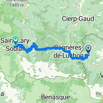
Ta trasa zaczyna się w Bossòst, ale równie dobrze może służyć rowerzystom przebywającym w Vielha, którzy mogą dotrzeć do Bossòst szerokimi poboczami N-230.
Zaczynamy w Bossòst, opuszczając miasto od południa wzdłuż rzeki Garona, a następnie skręcamy pod górę w prawo na rondzie na N-141. To początek Portilhon, przełęczy wyznaczającej granicę Hiszpanii i Francji. Rozpoczyna się serią zakrętów, z których rozciągają się wspaniałe widoki na Bossòst, wspina się obok parku Aran, a po przekroczeniu granicy na szczycie szybko opada do Francji.
W Saint-Mamet, jeśli masz dobre nogi, podążaj śladem GPS w lewo po przekroczeniu rzeki Pique, aby udać się na wspinaczkę do Superbagnères. Ta wspinaczka jest drogą jednokierunkową, co oznacza, że wspinasz się na szczyt i wracasz do tego punktu. Jeśli wolisz ją pominąć, skręć w prawo po przekroczeniu rzeki Pique i kontynuuj przez Bagnères de Luchon.
Jeśli zdecydujesz się na wspinaczkę do Superbagnères, podjazd szybko się zaostrza po opuszczeniu Saint-Mamet, z odcinkami o nachyleniu 12% w ciągu pierwszych dwóch kilometrów. Całkowita długość wspinaczki to 18,5 km i jest przeznaczona dla doświadczonych rowerzystów. Całkowity przewyższenie to 1170 m, co daje wysokość ponad 1800 m n.p.m., ze średnim nachyleniem 6,3%. W końcu opuścisz linię drzew, a krajobraz otworzy się na rozległe wysokogórskie pastwiska, z widokiem na wiele ze 3000-metrowych zaśnieżonych szczytów w regionie. Po dotarciu do stacji narciarskiej na szczycie pozostaje tylko zawrócić i cieszyć się zjazdem do Bagnères-de-Luchon!
Trasa teraz przecina Bagnères-de-Luchon z południa na północ, a następnie podąża wzdłuż rzeki Pique po D125 aż do Gaud, gdzie na rondzie skręcamy w prawo i dołączamy do D44 w kierunku Marignac. D44 to droga dość łatwa, która bardzo łagodnie pnie się po Marignac. Docieramy do doliny rzeki Garonne i skręcamy w prawo na N125, która nadal łagodnie wspina się wzdłuż doliny rzecznej, w kierunku granicy hiszpańskiej.
Punkty zainteresowania: Wspinaczka na Superbagnères jest pielgrzymką dla fanów Tour de France, którzy byli świadkami wielu słynnych pojedynków między najlepszymi kolarzami świata na jej podjazdach. To bardzo dzika okolica, a na trasie są piękne widoki (i dźwięki) rwącej rzeki Lys, płynącej wzdłuż drogi.
- -:--
- Czas
- 90,2 km
- Dystans
- 2386 m
- Przewyższenia
- 2386 m
- Spadek
- ---
- Śr. Prędkość
- ---
- Maks. wysokość

Jakość trasy
Typy dróg i nawierzchnie na trasie
Typy dróg
Droga
33,4 km
(37 %)
Spokojna droga
1,8 km
(2 %)
Powierzchnie
Utwardzona
46,9 km
(52 %)
Asfalt
46,9 km
(52 %)
Niezdefiniowany
43,3 km
(48 %)
Kontynuuj z Bikemap
Użyj, edytuj lub pobierz tę trasę rowerową
Chcesz przejechać trasę Road cycling. Val d'Aran - Pyrenees: Tour Vielha with Superbagneres lub dostosować ją do swojej wycieczki? Oto, co możesz zrobić z tą trasą na Bikemap:
Darmowe funkcje
- Zapisz tę trasę jako ulubioną lub w kolekcji
- Skopiuj i zaplanuj swoją wersję tej trasy
- Podziel trasę na etapy, aby utworzyć kilkudniową wycieczkę
- Synchronizuj swoją trasę z Garminem lub Wahoo
Funkcje Premium
3 dni bezpłatnej wersji próbnej lub jednorazowa opłata. Dowiedz się więcej o Bikemap Premium.
- Nawiguj po tej trasie na iOS i Androidzie
- Eksportuj plik GPX / KML tej trasy
- Stwórz swój własny wydruk (wypróbuj za darmo)
- Pobierz tę trasę do nawigacji offline
Odkryj więcej funkcji Premium.
Uzyskaj Bikemap PremiumOd naszej społeczności
Les: Inne popularne trasy rozpoczynające się tutaj
 Road cycling. Val d'Aran - Pyrenees: Tour Vielha with Superbagneres
- Dystans
- 90,2 km
- Przewyższenia
- 2386 m
- Spadek
- 2386 m
- Lokalizacja
- Les, Catalunya, Hiszpania
 transpirenaica etapa - vielha - colliure
- Dystans
- 336,1 km
- Przewyższenia
- 4760 m
- Spadek
- 5456 m
- Lokalizacja
- Les, Catalunya, Hiszpania
 Road Cycling: Aran - Haute Garonne Loop
- Dystans
- 136,4 km
- Przewyższenia
- 4122 m
- Spadek
- 4121 m
- Lokalizacja
- Les, Catalunya, Hiszpania
 PIRINEOS MÍTICOS 2020
- Dystans
- 386,7 km
- Przewyższenia
- 14 434 m
- Spadek
- 14 347 m
- Lokalizacja
- Les, Catalunya, Hiszpania
 waypoint puertos pirineos
- Dystans
- 51,7 km
- Przewyższenia
- 1322 m
- Spadek
- 981 m
- Lokalizacja
- Les, Catalunya, Hiszpania
 bossost
- Dystans
- 117,8 km
- Przewyższenia
- 2223 m
- Spadek
- 2223 m
- Lokalizacja
- Les, Catalunya, Hiszpania
 Pombair Tour 2012, 6. Tag
- Dystans
- 96,8 km
- Przewyższenia
- 1617 m
- Spadek
- 1641 m
- Lokalizacja
- Les, Catalunya, Hiszpania
 Bossot-Portillon-Peyragudes-Val Louron-Saint Lary Soulan
- Dystans
- 62,4 km
- Przewyższenia
- 2168 m
- Spadek
- 2057 m
- Lokalizacja
- Les, Catalunya, Hiszpania
Otwórz ją w aplikacji