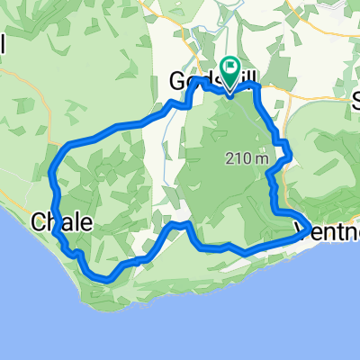
Ravens Route 21.2 miles.
Trasa rowerowa rozpoczynająca się w Ventnor, Anglia, Zjednoczone Królestwo Wielkiej Brytanii.
Przegląd
O tej trasie
Enjoying the slow climb to Blackgang view point, I often see ravens along this stretch. Today a very nosy pheasant watched from the roadside. Best descending sections: Upper Ventnor to the Undercliffe but watch the junction between Gills Cliff Road & Castle Road (traffic lights). Institute Hill, Niton (short but sweet!). Blackgang view point to Chale Street, fast with only one roundabout & Berry Shute to Highwood Lane, Chillerton. In order to extend this route to over 20 miles, take the Niton Road, just before Rookley to cut down through Beacon Alley which joins the Whitwell Road back to Godshill & Wroxall. Enjoy.
- -:--
- Czas
- 48,6 km
- Dystans
- 420 m
- Przewyższenia
- 428 m
- Spadek
- ---
- Śr. Prędkość
- ---
- Maks. wysokość
Jakość trasy
Typy dróg i nawierzchnie na trasie
Typy dróg
Droga
22,3 km
(46 %)
Ruchliwa droga
18,3 km
(38 %)
Powierzchnie
Utwardzona
46,9 km
(96 %)
Nieutwardzona
0,4 km
(<1 %)
Asfalt
46,9 km
(96 %)
Luźny żwir
0,2 km
(<1 %)
Kontynuuj z Bikemap
Użyj, edytuj lub pobierz tę trasę rowerową
Chcesz przejechać trasę Ravens Route 21.2 miles. lub dostosować ją do swojej wycieczki? Oto, co możesz zrobić z tą trasą na Bikemap:
Darmowe funkcje
- Zapisz tę trasę jako ulubioną lub w kolekcji
- Skopiuj i zaplanuj swoją wersję tej trasy
- Synchronizuj swoją trasę z Garminem lub Wahoo
Funkcje Premium
3 dni bezpłatnej wersji próbnej lub jednorazowa opłata. Dowiedz się więcej o Bikemap Premium.
- Nawiguj po tej trasie na iOS i Androidzie
- Eksportuj plik GPX / KML tej trasy
- Stwórz swój własny wydruk (wypróbuj za darmo)
- Pobierz tę trasę do nawigacji offline
Odkryj więcej funkcji Premium.
Uzyskaj Bikemap PremiumOd naszej społeczności
Ventnor: Inne popularne trasy rozpoczynające się tutaj
 Little Loop
- Dystans
- 20,2 km
- Przewyższenia
- 135 m
- Spadek
- 136 m
- Lokalizacja
- Ventnor, Anglia, Zjednoczone Królestwo Wielkiej Brytanii
 Wroxall Rookley Wroxall
- Dystans
- 22,4 km
- Przewyższenia
- 207 m
- Spadek
- 195 m
- Lokalizacja
- Ventnor, Anglia, Zjednoczone Królestwo Wielkiej Brytanii
 St. Lawrence & Undercliffe Drive.
- Dystans
- 23,4 km
- Przewyższenia
- 335 m
- Spadek
- 337 m
- Lokalizacja
- Ventnor, Anglia, Zjednoczone Królestwo Wielkiej Brytanii
 IOW 17 mile
- Dystans
- 25,6 km
- Przewyższenia
- 252 m
- Spadek
- 263 m
- Lokalizacja
- Ventnor, Anglia, Zjednoczone Królestwo Wielkiej Brytanii
 Isle of Wight 109km
- Dystans
- 109 km
- Przewyższenia
- 608 m
- Spadek
- 608 m
- Lokalizacja
- Ventnor, Anglia, Zjednoczone Królestwo Wielkiej Brytanii
 Wroxall - Brading Loop
- Dystans
- 22,5 km
- Przewyższenia
- 288 m
- Spadek
- 288 m
- Lokalizacja
- Ventnor, Anglia, Zjednoczone Królestwo Wielkiej Brytanii
 Chillerton Tour - Via Whitwell & Roud
- Dystans
- 35,4 km
- Przewyższenia
- 347 m
- Spadek
- 348 m
- Lokalizacja
- Ventnor, Anglia, Zjednoczone Królestwo Wielkiej Brytanii
 Alverstone Bombing Run
- Dystans
- 17,6 km
- Przewyższenia
- 124 m
- Spadek
- 122 m
- Lokalizacja
- Ventnor, Anglia, Zjednoczone Królestwo Wielkiej Brytanii
Otwórz ją w aplikacji


