

Schlierbach - Viechtwang
Trasa rowerowa rozpoczynająca się w Micheldorf in Oberösterreich, Górna Austria, Austria.
Przegląd
O tej trasie
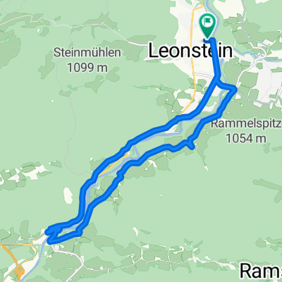
Łagodnie zaczynając przy przystanku Schlierbach, trasa prowadzi przez Inzersdorf na dłuższym wzniesieniu do najwyższego punktu (633 SH) na południe od Magdalenaberg i oferuje przyjemny zjazd aż do Scharnsteiner-Strasse (498 SH). Następnie lekko falująca aż do mostu Steinbach, a trasa przebiega w pobliżu rzeki Alm aż do R11 (Almtalweg). Na tym aż do Viechtwang i przez miejscowość. Po miejscowości w prawo wzniesienie w górę aż do kościoła i LGH Silmbrod (znajdują się znów na R11).
Trasa prowadzi w większości po mało ruchliwych drogach i oferuje przy dobrej widoczności wspaniałe widoki na wzgórza wokół Magdalenaberg i widoki na wiejskie krajobrazy oraz rzekę Alm.
Wskazówka: W czwartki do 12:30 w GH Silmbrod serwowane są gorące kiełbasy do skosztowania.
- -:--
- Czas
- 17,9 km
- Dystans
- 314 m
- Przewyższenia
- 203 m
- Spadek
- ---
- Śr. Prędkość
- ---
- Maks. wysokość

Jakość trasy
Typy dróg i nawierzchnie na trasie
Typy dróg
Spokojna droga
8,6 km
(48 %)
Droga
4,3 km
(24 %)
Powierzchnie
Utwardzona
6,1 km
(34 %)
Nieutwardzona
0,4 km
(2 %)
Asfalt
5,9 km
(33 %)
Nieutwardzony (nieokreślony)
0,4 km
(2 %)
Kontynuuj z Bikemap
Użyj, edytuj lub pobierz tę trasę rowerową
Chcesz przejechać trasę Schlierbach - Viechtwang lub dostosować ją do swojej wycieczki? Oto, co możesz zrobić z tą trasą na Bikemap:
Darmowe funkcje
- Zapisz tę trasę jako ulubioną lub w kolekcji
- Skopiuj i zaplanuj swoją wersję tej trasy
- Synchronizuj swoją trasę z Garminem lub Wahoo
Funkcje Premium
3 dni bezpłatnej wersji próbnej lub jednorazowa opłata. Dowiedz się więcej o Bikemap Premium.
- Nawiguj po tej trasie na iOS i Androidzie
- Eksportuj plik GPX / KML tej trasy
- Stwórz swój własny wydruk (wypróbuj za darmo)
- Pobierz tę trasę do nawigacji offline
Odkryj więcej funkcji Premium.
Uzyskaj Bikemap PremiumOd naszej społeczności
Micheldorf in Oberösterreich: Inne popularne trasy rozpoczynające się tutaj
 OBK Jagahäusl
- Dystans
- 45,5 km
- Przewyższenia
- 716 m
- Spadek
- 734 m
- Lokalizacja
- Micheldorf in Oberösterreich, Górna Austria, Austria
 Hochbaumgarten - Haindlmühle-Graben - Hochbaumgarten
- Dystans
- 16,2 km
- Przewyższenia
- 502 m
- Spadek
- 493 m
- Lokalizacja
- Micheldorf in Oberösterreich, Górna Austria, Austria
 RK Kremstalroas
- Dystans
- 140,4 km
- Przewyższenia
- 1670 m
- Spadek
- 1670 m
- Lokalizacja
- Micheldorf in Oberösterreich, Górna Austria, Austria
 Zimekrunde
- Dystans
- 18,1 km
- Przewyższenia
- 355 m
- Spadek
- 356 m
- Lokalizacja
- Micheldorf in Oberösterreich, Górna Austria, Austria
 Micheld. Sattlhald ZiehbergSender Lauterbach
- Dystans
- 33,7 km
- Przewyższenia
- 969 m
- Spadek
- 969 m
- Lokalizacja
- Micheldorf in Oberösterreich, Górna Austria, Austria
 Von Klaus an der Pyhrnbahn bis Rosenau am Hengstpaß
- Dystans
- 33,1 km
- Przewyższenia
- 1053 m
- Spadek
- 756 m
- Lokalizacja
- Micheldorf in Oberösterreich, Górna Austria, Austria
 Schlierbach - Viechtwang
- Dystans
- 17,9 km
- Przewyższenia
- 314 m
- Spadek
- 203 m
- Lokalizacja
- Micheldorf in Oberösterreich, Górna Austria, Austria
 2025_04_29_Micheldorf- Hochberghaus-Micheldorf
- Dystans
- 75,1 km
- Przewyższenia
- 1885 m
- Spadek
- 1886 m
- Lokalizacja
- Micheldorf in Oberösterreich, Górna Austria, Austria
Otwórz ją w aplikacji