

Shortcut to/and the extreme downhill path
Trasa rowerowa rozpoczynająca się w Błagojewgrad, Blagoevgrad, Bułgaria.
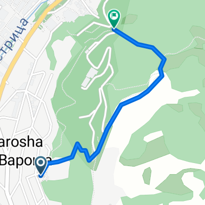
Przegląd
O tej trasie
W zasadzie jedziesz przez dzielnicę, wokół lewej strony zoo, do ogrodu różanego, a następnie w górę wzgórza obok anten i przez drogę.
Gdy dojdziesz do pierwszych drzew, miejsca, w którym rowerzyści przeskakują przez drogę, możesz zobaczyć po swojej lewej stronie kamień pomalowany na czerwono. Na całej trasie będziesz widzieć takie kamienie, aby pokazać ci drogę. Jednak za pierwszym razem sugeruję, abyś przeszedł tę trasę pieszo lub bardzo wolno.
Po pierwszym zakręcie ścieżka stromo opada. Chłopaki zbudowali dzikie skoki, zakręty boczne i wszystko, co wiąże się z jazdą w dół.
Z powodu moich umiejętności, które nie są zbyt dobre, cały czas hamowałem, a mimo to było dość trudno mi utrzymać się na ziemi. Na końcu powinieneś dużo skakać na bokach trasy, aby się utrzymać. Są też dość przerażające wysokie skoki.
Sprawdź zdjęcia na mapie, aby uzyskać lepszy obraz.
Używaj dobrego sprzętu i ochrony i krzycz!
- -:--
- Czas
- 1,1 km
- Dystans
- 85 m
- Przewyższenia
- 75 m
- Spadek
- ---
- Śr. Prędkość
- ---
- Maks. wysokość
Najważniejsze punkty trasy
Punkty zainteresowania na trasie

Zdjęcie po 0,5 km

Zdjęcie po 0,8 km

Zdjęcie po 0,8 km

Zdjęcie po 0,8 km
Start of the DH path

Zdjęcie po 0,8 km

Zdjęcie po 0,9 km

Zdjęcie po 0,9 km

Zdjęcie po 0,9 km

Zdjęcie po 0,9 km

Zdjęcie po 0,9 km

Zdjęcie po 1 km

Zdjęcie po 1 km
Crazy part here

Zdjęcie po 1 km
Very steep

Zdjęcie po 1,1 km
Nice

Zdjęcie po 1,1 km
The end
Kontynuuj z Bikemap
Użyj, edytuj lub pobierz tę trasę rowerową
Chcesz przejechać trasę Shortcut to/and the extreme downhill path lub dostosować ją do swojej wycieczki? Oto, co możesz zrobić z tą trasą na Bikemap:
Darmowe funkcje
- Zapisz tę trasę jako ulubioną lub w kolekcji
- Skopiuj i zaplanuj swoją wersję tej trasy
- Synchronizuj swoją trasę z Garminem lub Wahoo
Funkcje Premium
3 dni bezpłatnej wersji próbnej lub jednorazowa opłata. Dowiedz się więcej o Bikemap Premium.
- Nawiguj po tej trasie na iOS i Androidzie
- Eksportuj plik GPX / KML tej trasy
- Stwórz swój własny wydruk (wypróbuj za darmo)
- Pobierz tę trasę do nawigacji offline
Odkryj więcej funkcji Premium.
Uzyskaj Bikemap PremiumOd naszej społeczności
Błagojewgrad: Inne popularne trasy rozpoczynające się tutaj
 Blagoevgrad - Pehchevo
- Dystans
- 62,3 km
- Przewyższenia
- 1386 m
- Spadek
- 731 m
- Lokalizacja
- Błagojewgrad, Blagoevgrad, Bułgaria
 Razhodka okolo Blagoevgrad
- Dystans
- 20,7 km
- Przewyższenia
- 424 m
- Spadek
- 515 m
- Lokalizacja
- Błagojewgrad, Blagoevgrad, Bułgaria
 Shortcut to/and the extreme downhill path
- Dystans
- 1,1 km
- Przewyższenia
- 85 m
- Spadek
- 75 m
- Lokalizacja
- Błagojewgrad, Blagoevgrad, Bułgaria
 Blagoevgrad- Sapareva banya
- Dystans
- 50,3 km
- Przewyższenia
- 1160 m
- Spadek
- 798 m
- Lokalizacja
- Błagojewgrad, Blagoevgrad, Bułgaria
 Notre parcours en Macédoine
- Dystans
- 392,5 km
- Przewyższenia
- 3215 m
- Spadek
- 2575 m
- Lokalizacja
- Błagojewgrad, Blagoevgrad, Bułgaria
 Nice route to the near villas and back to Blago
- Dystans
- 9,4 km
- Przewyższenia
- 243 m
- Spadek
- 213 m
- Lokalizacja
- Błagojewgrad, Blagoevgrad, Bułgaria
 Scenic Route to Elenovo and back to Skapto
- Dystans
- 8,8 km
- Przewyższenia
- 283 m
- Spadek
- 303 m
- Lokalizacja
- Błagojewgrad, Blagoevgrad, Bułgaria
 Steep route to the almond forest
- Dystans
- 0,7 km
- Przewyższenia
- 50 m
- Spadek
- 29 m
- Lokalizacja
- Błagojewgrad, Blagoevgrad, Bułgaria
Otwórz ją w aplikacji