- 42,9 km
- 2023 m
- 1313 m
- Błagojewgrad, Blagoevgrad, Bułgaria
Near the river (right side) to the lake
Trasa rowerowa rozpoczynająca się w Błagojewgrad, Blagoevgrad, Bułgaria.
Przegląd
O tej trasie
Tą trasę przejechałem chyba milion razy, jest szybka, piękna, prowadzi nad jezioro i jest alternatywą do jazdy górskiej zamiast alejką w Bachinowie.
Więc zaczynasz od metalowego mostu, przechodzisz, skręcasz w lewo i idziesz wzdłuż rzeki. Po chwili musisz wspiąć się prawie na drogę. Potem na chodniku. W końcu kończy się i idziesz w lewo w kierunku metalowej bramy. To jest wejście na boisko baseballowe. Wjdź, przejedź sto jardów, a potem znowu w lewo wzdłuż siatki boiska baseballowego. Oto fajna część. Docierasz do rzeki, ścieżka jest kamienista i szybka, jedziesz kilka metrów od brzegu w lesie – ładnie. Po chwili docierasz do dziwnego asfaltowego okręgu, przejeżdżasz go i jesteś na małej asfaltowej drodze, która wkrótce zaprowadzi cię nad jezioro.
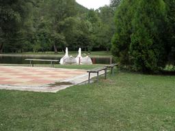
Przywiąż rower i wskakuj na łabędzia :)
- -:--
- Czas
- 2 km
- Dystans
- 70 m
- Przewyższenia
- 26 m
- Spadek
- ---
- Śr. Prędkość
- ---
- Maks. wysokość
utworzono 15 lat temu temu
Najważniejsze punkty trasy
Punkty zainteresowania na trasie

Zdjęcie po 0 km
Start across the metal rope bridge

Zdjęcie po 0,1 km

Zdjęcie po 0,2 km

Zdjęcie po 0,3 km

Zdjęcie po 0,3 km

Zdjęcie po 0,5 km
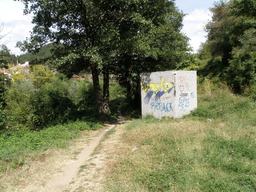
Enter the sport facilities /baseball field/ here

Interesujące miejsce po 0,6 km

Zdjęcie po 0,7 km

Zdjęcie po 0,9 km

Zdjęcie po 0,9 km

Zdjęcie po 1,2 km
The path seen from the other bank

Zdjęcie po 1,3 km

Zdjęcie po 1,5 km

Zdjęcie po 1,7 km

Zdjęcie po 1,8 km

Zdjęcie po 1,9 km
Kontynuuj z Bikemap
Użyj, edytuj lub pobierz tę trasę rowerową
Chcesz przejechać trasę Near the river (right side) to the lake lub dostosować ją do swojej wycieczki? Oto, co możesz zrobić z tą trasą na Bikemap:
Darmowe funkcje
- Zapisz tę trasę jako ulubioną lub w kolekcji
- Skopiuj i zaplanuj swoją wersję tej trasy
- Synchronizuj swoją trasę z Garminem lub Wahoo
Funkcje Premium
3 dni bezpłatnej wersji próbnej lub jednorazowa opłata. Dowiedz się więcej o Bikemap Premium.
- Nawiguj po tej trasie na iOS i Androidzie
- Eksportuj plik GPX / KML tej trasy
- Stwórz swój własny wydruk (wypróbuj za darmo)
- Pobierz tę trasę do nawigacji offline
Odkryj więcej funkcji Premium.
Uzyskaj Bikemap PremiumOd naszej społeczności
Błagojewgrad: Inne popularne trasy rozpoczynające się tutaj
- Blagoevgrad - Razlog
- Nailonka
- 2,4 km
- 0 m
- 286 m
- Błagojewgrad, Blagoevgrad, Bułgaria
- Route in Blagoevgrad
- 1,9 km
- 20 m
- 56 m
- Błagojewgrad, Blagoevgrad, Bułgaria
- EuroVelo 13 - Iron Curtain Trail - part Bulgaria West
- 63,7 km
- 1141 m
- 1831 m
- Błagojewgrad, Blagoevgrad, Bułgaria
- Благоевград - Рила - Благоевград
- 16,8 km
- 248 m
- 140 m
- Błagojewgrad, Blagoevgrad, Bułgaria
- Route in Blagoevgrad
- 1,6 km
- 0 m
- 47 m
- Błagojewgrad, Blagoevgrad, Bułgaria
- Делчево
- 71,3 km
- 1383 m
- 1383 m
- Błagojewgrad, Blagoevgrad, Bułgaria
- Jorden runt Östeuropa: Makedonien, Albanien, Grekland
- 1519,7 km
- 21 787 m
- 22 907 m
- Błagojewgrad, Blagoevgrad, Bułgaria
Otwórz ją w aplikacji


