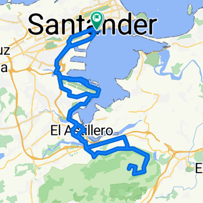
Puertos Cordillera Cantabrica

Trasa rowerowa rozpoczynająca się w Santander, Kantabria, Hiszpania.

Przegląd

O tej trasie

-:--
Czas
118,5 km
Dystans
870 m
Przewyższenia
838 m
Spadek
---
Śr. Prędkość
---
Maks. wysokość
u112fa

utworzono 17 lat temu temu

Najważniejsze punkty trasy

Punkty zainteresowania na trasie

  1. Interesujące miejsce po 7,9 km

  2. Interesujące miejsce po 7,9 km

  3. Interesujące miejsce po 7,9 km

    DOBRES-CUCAYO 981 m

  4. Interesujące miejsce po 7,9 km

    PTO SAN GLORIO 1609 m

  5. Interesujące miejsce po 7,9 km

    Collado de CARMONA 611 m

  6. Interesujące miejsce po 8 km

    Alto Campoo-Fuente del Chivo 1982 m

  7. Interesujące miejsce po 8 km

    PTO DE PIEDRASLUENGAS 1354 m

  8. Interesujące miejsce po 8,2 km

    GOLOBAR 1800 m

  9. Interesujące miejsce po 8,2 km

    PTO de la PALOMBERA 1260 m

  10. Interesujące miejsce po 11,3 km

    PUERTO EL ESCUDO 1011 M

  11. Interesujące miejsce po 11,5 km

    MANTANELA 1005 m

  12. Interesujące miejsce po 11,5 km

    PUERTO DE LA MATANELA 1005 m

  13. Interesujące miejsce po 11,6 km

    EL HITO 1011 m

  14. Interesujące miejsce po 11,8 km

    Puerto de la BRAGUÍA 720 m

  15. Interesujące miejsce po 13,8 km

    PEÑA CABARGA 569 m

  16. Interesujące miejsce po 29,7 km

    LA ESTRANGUADA 687 m

  17. Interesujące miejsce po 30,8 km

    EL CARACOL 822 m

  18. Interesujące miejsce po 35,6 km

    PTO DE LAS ESTACAS DE TRUEBA 1166 m

  19. Interesujące miejsce po 36 km

    PORTILLO DE LA LUNADA 1320 m

  20. Interesujące miejsce po 36,1 km

    PICÓN DEL FRAILE 1614 m

  21. Interesujące miejsce po 36,2 km

    Puerto de Alisas 674 m

  22. Interesujące miejsce po 36,5 km

    Portillo de la Sia 1250 m

  23. Interesujące miejsce po 36,5 km

    Collado de Asón 696 m

  24. Interesujące miejsce po 41,2 km

    Alto de Ajo 188 m

  25. Interesujące miejsce po 42,6 km

    PTO FUENTE DE LAS VARAS 450 m

  26. Interesujące miejsce po 48,1 km

    Campo La Cruz 388 m

  27. Interesujące miejsce po 54,5 km

    HITO 1011 m

  28. Interesujące miejsce po 54,7 km

    SAN PEDRO DE SOBA 690 m

  29. Interesujące miejsce po 54,7 km

    PICÓN BLANCO 1512 m

  30. Interesujące miejsce po 54,9 km

    Alcomba 540 m

  31. Interesujące miejsce po 55,1 km

    CAMPO LAYAL (LA APARECIDA) 418 m

  32. Interesujące miejsce po 57 km

    PTO LOS TORNOS 918 m

  33. Nocleg po 58,7 km

    LAREDO (PUNTAL)

  34. Interesujące miejsce po 62,7 km

    ALTO DE SEÑA 258 m

  35. Interesujące miejsce po 64,8 km

    EL CABRIO 755 m

  36. Interesujące miejsce po 64,8 km

    ROSALES 772 m

  37. Interesujące miejsce po 64,8 km

    UBAL 634 m

  38. Interesujące miejsce po 64,9 km

    PEÑA RANERO 488 m

  39. Interesujące miejsce po 65 km

    ALTO DE TORCOLLANO 360 m

  40. Interesujące miejsce po 65,1 km

    CAMPILLO 463 m

  41. Interesujące miejsce po 65,1 km

    LANZAS AGUDAS 407 m

  42. Interesujące miejsce po 65,2 km

    PTO. HOYOMENOR 362 m

  43. Interesujące miejsce po 65,3 km

    Na Sa de las Nieves 707 m

  44. Interesujące miejsce po 65,3 km

    Na Sa DE LAS NIEVES 707 m

  45. Interesujące miejsce po 67,9 km

    SAN MAMÉS DE LUGAREJOS 215 m - 9 %

  46. Interesujące miejsce po 69,6 km

    ALTO DE TORQUIENDO 260 m

  47. Interesujące miejsce po 75,4 km

    PTO DE LA GRANJA 395 m

  48. Interesujące miejsce po 102 km

    LA ESCRITA 430 m

  49. Interesujące miejsce po 102,1 km

    Bo POVEDAL 355 m

  50. Interesujące miejsce po 102,1 km

    GORDÕN 486 m

  51. Interesujące miejsce po 102,3 km

    EL CAREL 450 m

  52. Interesujące miejsce po 102,5 km

    RO 546 m

  53. Interesujące miejsce po 102,6 km

    ALEN 539 m

  54. Interesujące miejsce po 108,4 km

    PTO DE LAS MUÑECAS 372 m

  55. Interesujące miejsce po 108,5 km

    Bo de BECI 336 m

  56. Interesujące miejsce po 108,5 km

    VIERGOL 482 m

  57. Interesujące miejsce po 108,5 km

    PEÑA ANGULO 728 m

  58. Interesujące miejsce po 114 km

    TORRE DE LOIZAGA 290 m

  59. Interesujące miejsce po 114,4 km

    HUMARAN 247 m

  60. Interesujące miejsce po 114,5 km

    PEÑAS NEGRAS 490 m

  61. Zdjęcie po 116,8 km

    SERANTES 445 m

  62. Interesujące miejsce po 118,5 km

    SAN MARTIN 333 m

  63. Interesujące miejsce po 118,5 km

    Balcón de Bizkaia 426 m

  64. Interesujące miejsce po 118,5 km

    ARGALARIO 548 m

  65. Interesujące miejsce po 118,5 km

    SAN COSME 238 m

  66. Interesujące miejsce po 118,5 km

    LA ARBOLEDA 462 m

  67. Zdjęcie po 118,5 km

    sans nom

  68. Interesujące miejsce po 118,5 km

    LAGUNAS DE NEILA 1872 m

  69. Interesujące miejsce po 118,5 km

    PICO VELETA 3367 m

Kontynuuj z Bikemap

Użyj, edytuj lub pobierz tę trasę rowerową

Chcesz przejechać trasę Puertos Cordillera Cantabrica lub dostosować ją do swojej wycieczki? Oto, co możesz zrobić z tą trasą na Bikemap:

Darmowe funkcje

Funkcje Premium

3 dni bezpłatnej wersji próbnej lub jednorazowa opłata. Dowiedz się więcej o Bikemap Premium.

Odkryj więcej funkcji Premium.

Uzyskaj Bikemap Premium

Od naszej społeczności

Santander: Inne popularne trasy rozpoczynające się tutaj

Otwórz ją w aplikacji