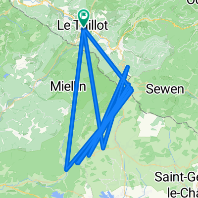
Col du Ballon de Servance - La Planche des belles filles - Col du Ballon d'Alsace
Trasa rowerowa rozpoczynająca się w Le Thillot, Grand Est, Francja.
Przegląd
O tej trasie
Vogezenrit met Col du Ballon de Servance - La Planche des belles filles - Col du Ballon d'Alsace. De route start in het dorpje Thillot en we beginnen meteen met het beklimmen van de Col d’Amic. Eens we de top bereikt hebben fietsen we verder bergop de Col du Ballon de Servance omhoog. Samen goed voor zo een 14 km klimwerk. Na de afdaling volgt de zware klim, La Planche Des Belles Filles. Deze werd al meerdere malen de eindbeklimming in etappes tijdens Le Tour de France. Daarna fietsen we van het dorpje Plancher-bas naar het dorpje Giromagny. Hier start de klim van de Ballon d’Alsace, een beklimming van 16km die slingert via enkele haarspeldbochten naar de top. Vanaf de top fietsen we verder bergaf naar ons beginpunt.
- -:--
- Czas
- 2277,8 km
- Dystans
- 494 572 m
- Przewyższenia
- 494 572 m
- Spadek
- ---
- Śr. Prędkość
- 1205 m
- Maks. wysokość
Kontynuuj z Bikemap
Użyj, edytuj lub pobierz tę trasę rowerową
Chcesz przejechać trasę Col du Ballon de Servance - La Planche des belles filles - Col du Ballon d'Alsace lub dostosować ją do swojej wycieczki? Oto, co możesz zrobić z tą trasą na Bikemap:
Darmowe funkcje
- Zapisz tę trasę jako ulubioną lub w kolekcji
- Skopiuj i zaplanuj swoją wersję tej trasy
- Podziel trasę na etapy, aby utworzyć kilkudniową wycieczkę
- Synchronizuj swoją trasę z Garminem lub Wahoo
Funkcje Premium
3 dni bezpłatnej wersji próbnej lub jednorazowa opłata. Dowiedz się więcej o Bikemap Premium.
- Nawiguj po tej trasie na iOS i Androidzie
- Eksportuj plik GPX / KML tej trasy
- Stwórz swój własny wydruk (wypróbuj za darmo)
- Pobierz tę trasę do nawigacji offline
Odkryj więcej funkcji Premium.
Uzyskaj Bikemap PremiumOd naszej społeczności
Le Thillot: Inne popularne trasy rozpoczynające się tutaj
- Vogezen 2016 83k 2300hm zuid (Le Thillot)
- Dystans
- 83,1 km
- Przewyższenia
- 2130 m
- Spadek
- 2130 m
- Lokalizacja
- Le Thillot, Grand Est, Francja
- Col du Ballon de Servance - La Planche des belles filles - Col du Ballon d'Alsace
- Dystans
- 2277,8 km
- Przewyższenia
- 494 572 m
- Spadek
- 494 572 m
- Lokalizacja
- Le Thillot, Grand Est, Francja
- Le Thillot - Voie verte
- Dystans
- 52,1 km
- Przewyższenia
- 273 m
- Spadek
- 276 m
- Lokalizacja
- Le Thillot, Grand Est, Francja
- Vogezen 2016 86k 1900hm
- Dystans
- 86 km
- Przewyższenia
- 1823 m
- Spadek
- 1823 m
- Lokalizacja
- Le Thillot, Grand Est, Francja
- Tour de France Route part 2
- Dystans
- 11,6 km
- Przewyższenia
- 212 m
- Spadek
- 261 m
- Lokalizacja
- Le Thillot, Grand Est, Francja
- Col des Croix - Col de Chevrères - Ballon de Servance
- Dystans
- 58 km
- Przewyższenia
- 1351 m
- Spadek
- 1351 m
- Lokalizacja
- Le Thillot, Grand Est, Francja
- itinéraire (col des croix, Chevrères, planche de belles filles, ballon de Servance, ballon d'Alcace, col du page, col de morbieux.
- Dystans
- 134,4 km
- Przewyższenia
- 3033 m
- Spadek
- 3035 m
- Lokalizacja
- Le Thillot, Grand Est, Francja
- Le Thillot - La Bresse
- Dystans
- 28,9 km
- Przewyższenia
- 1227 m
- Spadek
- 986 m
- Lokalizacja
- Le Thillot, Grand Est, Francja
Otwórz ją w aplikacji