

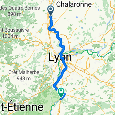
Villefranche s/s - Fleurville
Trasa rowerowa rozpoczynająca się w Fareins, Owernia-Rodan-Alpy, Francja.
Przegląd
O tej trasie
Chemin de Halage du bord de Saône
- -:--
- Czas
- 58 km
- Dystans
- 68 m
- Przewyższenia
- 60 m
- Spadek
- ---
- Śr. Prędkość
- ---
- Maks. wysokość
Jakość trasy
Typy dróg i nawierzchnie na trasie
Typy dróg
Ścieżka
32,2 km
(56 %)
Droga leśna
11,7 km
(20 %)
Powierzchnie
Utwardzona
16,5 km
(29 %)
Nieutwardzona
34,9 km
(60 %)
Żwir
20,7 km
(36 %)
Asfalt
16,5 km
(28 %)
Najważniejsze punkty trasy
Punkty zainteresowania na trasie
Interesujące miejsce po 10,2 km
Pont de Montmerle s/s
Interesujące miejsce po 12,7 km
Pont de Belleville s/s
Interesujące miejsce po 21,8 km
Pont de thoissey
Interesujące miejsce po 24,4 km
Pont de Romanèche
Interesujące miejsce po 30,8 km
Pont de Creche s/s
Interesujące miejsce po 34,6 km
Pont SNCF
Interesujące miejsce po 37,9 km
Pont
Interesujące miejsce po 39,2 km
Pont du canal
Interesujące miejsce po 39,6 km
Nouveau pont de Macon
Interesujące miejsce po 41,2 km
Pont de Saint Laurent
Interesujące miejsce po 45,3 km
Pont autoroutier
Kontynuuj z Bikemap
Użyj, edytuj lub pobierz tę trasę rowerową
Chcesz przejechać trasę Villefranche s/s - Fleurville lub dostosować ją do swojej wycieczki? Oto, co możesz zrobić z tą trasą na Bikemap:
Darmowe funkcje
- Zapisz tę trasę jako ulubioną lub w kolekcji
- Skopiuj i zaplanuj swoją wersję tej trasy
- Synchronizuj swoją trasę z Garminem lub Wahoo
Funkcje Premium
3 dni bezpłatnej wersji próbnej lub jednorazowa opłata. Dowiedz się więcej o Bikemap Premium.
- Nawiguj po tej trasie na iOS i Androidzie
- Eksportuj plik GPX / KML tej trasy
- Stwórz swój własny wydruk (wypróbuj za darmo)
- Pobierz tę trasę do nawigacji offline
Odkryj więcej funkcji Premium.
Uzyskaj Bikemap PremiumOd naszej społeczności
Fareins: Inne popularne trasy rozpoczynające się tutaj
 Fareins - Saint-Cyr-sur-le-Rhône
- Dystans
- 83,2 km
- Przewyższenia
- 561 m
- Spadek
- 579 m
- Lokalizacja
- Fareins, Owernia-Rodan-Alpy, Francja
 Villefranche s/s - Fleurville
- Dystans
- 58 km
- Przewyższenia
- 68 m
- Spadek
- 60 m
- Lokalizacja
- Fareins, Owernia-Rodan-Alpy, Francja
 De Route Départementale 933, Fareins à 52 Rue Gambetta, Pont-à-Mousson
- Dystans
- 442,1 km
- Przewyższenia
- 1588 m
- Spadek
- 1583 m
- Lokalizacja
- Fareins, Owernia-Rodan-Alpy, Francja
 Chemin du Bord de Saône, Fareins to 19 Rue Alsace-Lorraine, Lyon
- Dystans
- 49,9 km
- Przewyższenia
- 2978 m
- Spadek
- 3161 m
- Lokalizacja
- Fareins, Owernia-Rodan-Alpy, Francja
 Chemin de Halage, Beauregard à 82 Rue Jules Ferry, Beauregard
- Dystans
- 9,2 km
- Przewyższenia
- 187 m
- Spadek
- 188 m
- Lokalizacja
- Fareins, Owernia-Rodan-Alpy, Francja
 De 179–448 Chemin du Bord de Saône, Fareins à 68bis Rue de Saint-Trivier, Montmerle-sur-Saône
- Dystans
- 7,1 km
- Przewyższenia
- 31 m
- Spadek
- 10 m
- Lokalizacja
- Fareins, Owernia-Rodan-Alpy, Francja
 592–796 Chemin du Bord de Saône, Fareins nach 34 Quai Arloing, Lyon
- Dystans
- 41,8 km
- Przewyższenia
- 926 m
- Spadek
- 892 m
- Lokalizacja
- Fareins, Owernia-Rodan-Alpy, Francja
 Messimy-sur-Saône naar Quai Sud, Montmerle-sur-Saône
- Dystans
- 23 km
- Przewyższenia
- 194 m
- Spadek
- 197 m
- Lokalizacja
- Fareins, Owernia-Rodan-Alpy, Francja
Otwórz ją w aplikacji