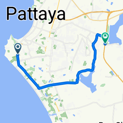
From Amphoe Bang Lamung to Amphoe Sattahip
- 23,9 km
- 80 m
- 81 m
- Pattaya, Prowincja Chonburi, Tajlandia
Trasa rowerowa rozpoczynająca się w Pattaya, Prowincja Chonburi, Tajlandia.
Przegląd
Start @ La Cerise Guesthouse on Soi Lengkee, Pattaya 3rd Road - head to Sukhumvit - turn right @ Mosque - follow Phon Prapha Road to meeting point @ 7 Eleven intersection Phon Prapha and Nongprue Road/Phon Prapha Nimit 22 - Start all tours with the Pattaya Road Cycling Community here: Head South to Phoenix Golf and Country Club - then to Wat Yannasang and Phra Maha Mondo Putthabat - another loop to Emerald Company Ltd - cross Highway No. 3 - follow down South to the Beach - turn West and ride to Phla - go back North to Highway No. 3 Sukhumvit dir. Satthahip past U-Tapao Airport - turn right on 3126 @ Phlu Ta Luang and go to the Beach - time for a Drink or Snack there @ km 100 - go back to No 3 and turn left - eventually turn right again and head North to reach Highway 332 - turn left and follow - turn right and go North again to Wan Pen and pass Khao Chi Chan Junction Railway Station - then head North again on small side roads - pass Phoenix Golf and Country club again, this time on the Western side - follow Canal Road North and eventually return to La Cerise Guesthouse
utworzono 15 lat temu temu
Kontynuuj z Bikemap
Chcesz przejechać trasę Pattaya's South lub dostosować ją do swojej wycieczki? Oto, co możesz zrobić z tą trasą na Bikemap:
3 dni bezpłatnej wersji próbnej lub jednorazowa opłata. Dowiedz się więcej o Bikemap Premium.
Odkryj więcej funkcji Premium.
Uzyskaj Bikemap PremiumOd naszej społeczności
Otwórz ją w aplikacji