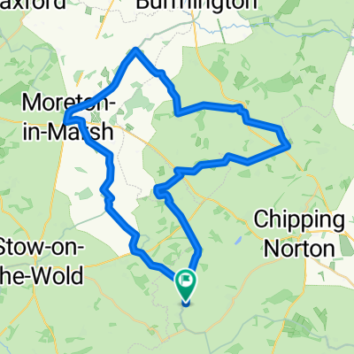
Marilina's Daylesford Ride
- 38,2 km
- 302 m
- 292 m
- Chipping Norton, Anglia, Zjednoczone Królestwo Wielkiej Brytanii
Ta trasa o długości 90 mil (148 km) jest ostatnim odcinkiem "The Way of the Rings", 555-kilometrowej trasy od Kamiennego Kręgu Castlerigg w regionie Lake District do Stonehenge, przebiegającej przez lub w pobliżu neolitycznych i historycznych miejsc zainteresowania. Śledzi prawdopodobną trasę przebywaną przez ludzi z epoki neolitu, którzy wyruszali ze swoimi świniami i bydłem do Stonehenge na przesilenie zimowe.
Można ją pokonać w ciągu 1-2 dni, odwiedzając każde z tych miejsc:
Rollright Stones (blisko Chipping Norton) – Rollright Stones to starożytne miejsce położone na granicy hrabstw Oxfordshire i Warwickshire w Anglii. Kompleks składa się z trzech głównych elementów: kamiennego kręgu Kings Men, King Stone oraz Whispering Knights.
Blenheim Palace – przez teren; Blenheim Palace to miejsce wpisane na listę światowego dziedzictwa z ponad 300-letnią historią, będące domem 12. księcia Marlborough i jego rodziny. Historyczna rezydencja i ogrody w hrabstwie Oxfordshire.
Uffington White Horse – Uffington White Horse to prehistoryczna sylwetka na wzgórzu, długa na 110 m, utworzona z głębokich rowów wypełnionych sproszkowanym białym kredą. Figura znajduje się na górnych stokach White Horse Hill, przez które przebiega trasa.
Stanton Harcourt – The Devil's Quoits, monument henge, był używany w późnym neolicie i w okresie kultury dzwonowatej, składał się z kamiennego kręgu z wałem ziemnym o średnicy około 85 stóp (ok. 26 m), złożonego z 30 lub więcej kamieni; w dużej mierze zniszczony w średniowieczu na potrzeby uprawy, niektóre kamienie zostały połamane i prawdopodobnie ponownie wykorzystane w kościele Stanton Harcourt.
Avebury – Avebury to neolityczny monument henge zawierający trzy kręgi kamienne wokół wsi Avebury. Jedno z najlepiej znanych prehistorycznych miejsc w Wielkiej Brytanii, zawiera największy megalityczny krąg kamienny na świecie.
Durrington Walls – Durrington Walls to miejsce dużego osadnictwa neolitycznego i późniejszego obwodu henge położone w obszarze światowego dziedzictwa Stonehenge, 3,2 km na północny wschód od Stonehenge.
Woodhenge – Woodhenge to atmosferyczne stanowisko neolityczne blisko Stonehenge. Prawdopodobnie zbudowane około 2500 p.n.e., pierwotnie uważano, że są to pozostałości grobowca, otoczonego wałem i fosą, prawie całkowicie zniszczone przez orkę.
Stonehenge – początek lub koniec trasy – Stonehenge to prehistoryczny pomnik położony 3 km na zachód od Amesbury. Składa się z pierścienia stojących kamieni, każdy o wysokości około 4 m, szerokości 2,1 m i wadze około 25 ton. Kamienie ustawione są w ziemnych umocnieniach w centrum najgęstszego kompleksu neolitycznych i brązowych zabytków w Anglii, w tym kilkuset kurhanów (kopców grobowych). Archeolodzy uważają, że został zbudowany w okresie od 3000 p.n.e. do 2000 p.n.e.
Trasę można przejechać z północy na południe lub odwrotnie. Na całej długości dostępne są noclegi oraz znakomite wiejskie puby.
Transport – stacje kolejowe w Salisbury (z bezpośrednim połączeniem do Londynu) i Pewsey. Istnieje transport do i z Stonehenge (ale nieprzyjazny dla rowerów), co oznacza konieczność zostawienia rowerów zamkniętych w Stonehenge i skorzystania z transportu do stacji kolejowej Salisbury, aby odebrać samochód itp. Jeśli trasę pokonuje się w 1,5-2 dni, istnieje możliwość podróży pociągiem z Oxfordu do Salisbury (przez Reading i Basingstoke).


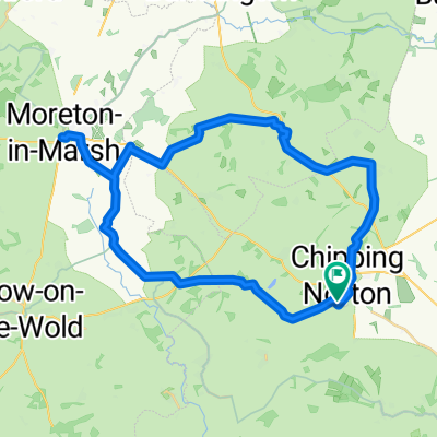
Droga
35,4 km38 %Spokojna droga
28,8 km31 %Utwardzona
58,6 km(63 %)Nieutwardzona
0,9 km(1 %)Asfalt
58,6 km63 %Ziemia
0,9 km1 %Niezdefiniowany
33,5 km36 %
Great Rollright - The oldest, the Whispering Knights dolmen, is early Neolithic, circa 3,800-3,500 BC, the King's Men stone circle is late Neolithic, circa 2,500 BC; and the King Stone is early to middle Bronze Age, circa 1,500 BC. The Stones are made of natural boulders of Jurassic oolitic limestone which forms the bulk of the Cotswold hills. This stone has been used extensively in the region for building everything from churches and houses to stone walls. The boulders used to construct the Rollright Stones were probably collected from within 500m of the site. The origins of the name The origin of the name ‘Rollright’ is somewhat uncertain. One interpretation is that it is derived from the Old English ‘Hrolla’+ ‘landriht’, the land-right or property of Hrolla. Old English is the earliest historical form of the English language brought to England by Anglo-Saxon settlers probably in the mid 5th century. Another theory is that it is derived from an even older Celtic language ‘rod’ + ‘land’ + ‘ricc’ meaning the ‘ricc’ (groove, gorge or steep valley) by the ‘rodland’ (wheel arena) – i.e. the stone circle.
Hoar Stone at Enstone This was evidently a site of considerable, importance in ancient days if the volume of folklore has anything to go by! Nearly hidden in a small wooded enclosure, between Enstone and Fulwell, where the B4022 meets the Enstone to Ditchley road, we find the ruins of this large chambered tomb. Although today only comprising of three large stones, one of which is almost nine feet tall, when Crawford [1925] visited here there were six stones visible and the remnants stood upon a mound of earth, which is no longer visible. He thought it to be the remains of a dolmen, surrounded by earth, but until substantial excavation work occurs, it is impossible to tell. The present entrance to the site comes from the east.
The remains of North Leigh Roman Villa are set within a peaceful landscape on the banks of the river Evenlode in Oxfordshire. This ‘courtyard villa’ is considered to be one of the larger villas of Roman Britain. It was at its most extensive in the early 4th century, when it included three bath suites, 16 mosaic floors and 11 rooms with under-floor heating. Today, two ranges of the former courtyard arrangement of the villa are visible. The most important feature of the site is a fine mosaic tile floor dating to the early 4th century.
Well worth visiting the Roman villa - slight deviation from route!
Devil's Quoits Fully restored Stone Circle in Oxfordshire. The site is believed to be between 4000 and 5000 years old, and is a Scheduled Ancient Monument. The Quoits were restored between 2002 and 2008, with stones which had been knocked over or had fallen over being re-uprighted, and the surrouding earthworks re-built. Access: Hamish Fenton writes: you can visit pretty much any time you want depending on where you park your vehicle. There are currently no signs saying "This way to the Devils Quoits". Route 1. (c.450 metres from the car). Just outside Stanton Harcourt of the B4449 a "Recycling Centre" is signposted if you follow the signs to it, then continue just past it you will see a small parking area on your left next to the lake (almost opposite a weighbridge), I think this is where you are supposed to park. the parking area is at the southern end of the lake, there is a gravel path with a wire fence on either side leading off around the lake from the corner of the parking area, follow this path and it will take you around the lake to the Devils Quoits, there are some newly planted trees that you will walk past, when the trees on your right finish, turn sharply around the end of the trees and walk up the slope, you should be at the entrance to the Devils Quoits, there is an information board here. note: the road to the recycling centre is gated and will be locked when the recycling centre is shut
These ditches were laid out to capture burial mounds in which their own ancestors had buried their dead 1,000 years before the ditch builders." "The ditches connect those ancestral remains with natural elements in the landscape in such a way that they could draw down the sacred power of the rising full moon that occurred only once every 18 years. The rivers were equally important for prehistoric people as living forces running through their landscape." "So the ditches are aligned with the River Windrush where it meets the Thames at Newbridge, cuts across a long loop of the Thames before crossing it and heading over Hurst and Cumnor Hills. It ends up at the point where the River Cherwell meets the Thames on Christchurch Meadows."
Hillfort in Oxfordshire From SolarMegalith: Cherbury Camp is located SW from Lovell Court Farm. This multivallate Iron Age fort covers area of 9 acres, the earthworks are in decent condition. In northern part of the hillfort three lines of ramparts and ditches are clearly distinguishable, while on the area enclosed with the ramparts cropmark of a hut circle is visible. The entrance in eastern sector of the hillfort is the original one, the southern was cut in 1930s. Archaeological excavations unearthed Bronze Age arrowheads, Iron Age pottery and coin, as well as Anglo-Saxon brooch. The footpath leading to Cherbury Camp leads through Lovell Court Farm, but it's well disguised - ask the landowner for help, he is a very kind and helpful person.
Uffington Castle Neolithic long barrow submitted by h_fenton Uffington Castle Neolithic long barrowA Neolithic long barrow, 25 metres long by up to 12 metres across and 0.3 metres high. The barrow is aligned roughly southwest to northeast about 70 metres north of Uffington Castle. The long barrow also seems to be the focal point of a later Romano-British inhumation cemetery. The barrow was partially excavated in 1857 when a shaft was dug into the middle (you can still see a depression). A cremation in a large coarse urn was found. Later in the Roman period the barrow became the focus of an inhumation cemetery, 46 skeletons were found in 42 graves some of the skulls were found with coins in their mouths which dated them to be late Roman. In June 1993 some geophysical surveys were done and the barrow was partially re-excavated, this revealed that most of the human remains were still in situ although many of the skulls were missing (the skulls may have been removed during the 1857 excavation)
Causewayed Enclosure in Oxfordshire Rams Hill Fort. Not actually a fort but a 'causewayed camp' between Uffington Castle and Segsbury Camp on The Ridgeway.
Wayland's Smithy This long barrow lies in a plantation of trees on the famous Ridgeway, not far from the Uffington White Horse in Oxfordshire. Footpaths lead to the site from both the Uffington Castle carpark and the B4000 which crosses the Ridgeway around a kilometre away. Excavations in the 1960s revealed the barrow was constructed in two phases - a wooden mortuary enclosure with stone floor was later covered by a trapezoidal mound of chalk. Inside there are three chambers, one main one and two to the sides. The long barrow was reconstructed after excavations - pieces of green plastic trellis can be seen protruding from the mound material near the entrance!
Lambourn Long Barrow Lambourn Long BarrowThis long barrow is dated to be one of the earliest in Britain, however little of it remains. The mound is extant, 70m by 18m altough difficult to see its full extent. The barrows is half covered in very tall trees at the end of a small wood. At the western end is a large stone 1m x 1m while at the eastern end is a pile of stones which may have formed some of the barrows structure. Halfway along the southern side is a stone 0.5x x 0.5m. The barrow should be considered in the context of the nineteen round barrows which form the extended Lambourn Barrow Cemetery which are nearby.
Uffington White Horse This beautiful hill carving, lying close to Uffington Hillfort in Oxfordshire is best viewed from a distance but can be accessed by walking uphill from the signposted carpark. The horse is 110m long and carved through the grass into chalk and has been dated to between 1400 and 600BC. (but see comments below for recent dating update) The Uffington White Horse is a highly stylized prehistoric hill figure situated on the upper slopes of White Horse Hill. The figure has been shown to date to the Bronze Age, by means of optically stimulated luminescence dating carried out following archaeological investigations in 1994. These studies produced three dates ranging between 1400 and 600 BC. Iron Age coins that bear a representation comparable to the Uffington White Horse have been found, supporting the early dating of this artifact; counter suggestions that the figure was fashioned in the Anglo-Saxon period now seem untenable. Uffington is by far the oldest of the white horse figures in Britain, and is of an entirely different design from the others. It has long been debated whether the chalk figure was intended to represent a horse or some other animal. The site is owned and managed by the National Trust. Last time we visited, a handy guide book to the monuments in the area could be purchased at the carpark
Durrington Walls is the site of a large Neolithic settlement and later henge enclosure located in the Stonehenge World Heritage Site in England. It lies 2 miles (3.2 km) north-east of Stonehenge in the parish of Durrington, just north of Amesbury in Wiltshire. The henge is the second-largest Late Neolithic palisaded enclosure known in the United Kingdom, after Hindwell in Wales
Woodhenge is an atmospheric Neolithic site close to Stonehenge. Probably built about 2500 BC, it was formed of six concentric ovals of standing posts, surrounded by a bank and ditch. The site was discovered by aerial photography in 1925, when rings of dark spots were spotted in a crop of wheat. Today, concrete markers show the positions of the timber posts
An 'avenue', originally of around 100 pairs of prehistoric standing stones, raised to form a winding 1 1/2 mile ritual link between the pre-existing monuments of Avebury and The Sanctuary. Part of the Avebury World Heritage Site.
Silbury Hill is a prehistoric artificial chalk mound near Avebury in the English county of Wiltshire. It is part of the Stonehenge, Avebury and Associated Sites UNESCO World Heritage Site. At 39.3 metres (129 ft) high, it is the tallest prehistoric man-made mound in Europe and one of the largest in the world; similar in size to some of the smaller Egyptian pyramids of the Giza Necropolis.
West Kennet Long Barrow West Kennet Long Barrow is a Neolithic long barrow dating to 5,650 years ago. With its large facade and long chalk barrow it is a striking monument, you can also go into the tomb and explore the chambers within. West Kennet Long Barrow was built 5,650 years ago and was used for around 1,000 years.
Stonehenge is perhaps the world’s most famous prehistoric monument. It was built in several stages: the first monument was an early henge monument, built about 5,000 years ago, and the unique stone circle was erected in the late Neolithic period about 2500 BC. In the early Bronze Age many burial mounds were built nearby. Today, together with Avebury, Stonehenge forms the heart of a World Heritage Site, with a unique concentration of prehistoric monuments.
The Barge Inn Great Canal side pub!
Honey street Cafe - great value and excellent service!
Avebury Avebury is part of an extraordinary set of Neolithic and Bronze Age ceremonial sites that seemingly formed a vast sacred landscape. They include West Kennet Avenue, West Kennet Long Barrow, The Sanctuary, Windmill Hill, and the mysterious Silbury Hill. Many can be reached on foot from the village.
3 dni bezpłatnej wersji próbnej lub jednorazowa opłata. Dowiedz się więcej o Bikemap Premium.
Odkryj więcej funkcji Premium.
Uzyskaj Bikemap PremiumOtwórz ją w aplikacji