

B2B00870 55116>55343 via MississippiRvBlvd/LakeStBridge/W.RiverRd/Greenway/Blake/Excel
Trasa rowerowa rozpoczynająca się w Mendota Heights, Minnesota, USA.
Przegląd
O tej trasie
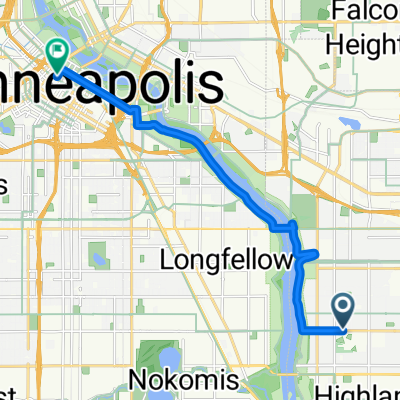
Weź Hartford do Mississippi River Blvd. Skręć w prawo i kontynuuj do mostu Marshall/Lake St. Przejedź do Minneapolis i skręć w prawo w West River Road. Jedź na północ po West River Road do 27th Avenue (tuż przed mostem) oraz zjazdu na szlak rowerowy Greenway. Na 28th Street możesz przejść na drugą stronę Hiawatha Avenue na światłach lub jechać na północ i skorzystać z nowego mostu Martina Sabo nad Hiawatha. Jedź Greenway na zachód, aż dotrzesz do Blake Road. Skręć w lewo na Excelsior Blvd. Skręć w lewo na Excelsior Blvd w kierunku Interlachen Road. Skręć w prawo do swojego celu.
- -:--
- Czas
- 21,2 km
- Dystans
- 114 m
- Przewyższenia
- 96 m
- Spadek
- ---
- Śr. Prędkość
- ---
- Maks. wysokość
Najważniejsze punkty trasy
Punkty zainteresowania na trasie
Interesujące miejsce po 7,4 km
At this point you can either cross Hiawatha directly or take the Martin Sabo bridge to the north.
Kontynuuj z Bikemap
Użyj, edytuj lub pobierz tę trasę rowerową
Chcesz przejechać trasę B2B00870 55116>55343 via MississippiRvBlvd/LakeStBridge/W.RiverRd/Greenway/Blake/Excel lub dostosować ją do swojej wycieczki? Oto, co możesz zrobić z tą trasą na Bikemap:
Darmowe funkcje
- Zapisz tę trasę jako ulubioną lub w kolekcji
- Skopiuj i zaplanuj swoją wersję tej trasy
- Synchronizuj swoją trasę z Garminem lub Wahoo
Funkcje Premium
3 dni bezpłatnej wersji próbnej lub jednorazowa opłata. Dowiedz się więcej o Bikemap Premium.
- Nawiguj po tej trasie na iOS i Androidzie
- Eksportuj plik GPX / KML tej trasy
- Stwórz swój własny wydruk (wypróbuj za darmo)
- Pobierz tę trasę do nawigacji offline
Odkryj więcej funkcji Premium.
Uzyskaj Bikemap PremiumOd naszej społeczności
Mendota Heights: Inne popularne trasy rozpoczynające się tutaj
 B2B00870 55116>55343 via MississippiRvBlvd/LakeStBridge/W.RiverRd/Greenway/Blake/Excel
- Dystans
- 21,2 km
- Przewyższenia
- 114 m
- Spadek
- 96 m
- Lokalizacja
- Mendota Heights, Minnesota, USA
 B2B00191 55115>55401viaRandolph/MissBlvd/LkStBridge/WRiverPkwy/WashAv
- Dystans
- 11,6 km
- Przewyższenia
- 97 m
- Spadek
- 109 m
- Lokalizacja
- Mendota Heights, Minnesota, USA
 Big Rivers, Pilot Knob, Acadia, Valley Park, ...
- Dystans
- 13,3 km
- Przewyższenia
- 206 m
- Spadek
- 206 m
- Lokalizacja
- Mendota Heights, Minnesota, USA
 Snail-like route in Mendota Heights
- Dystans
- 14 km
- Przewyższenia
- 325 m
- Spadek
- 325 m
- Lokalizacja
- Mendota Heights, Minnesota, USA
 Mendota to Calhoun
- Dystans
- 22 km
- Przewyższenia
- 171 m
- Spadek
- 132 m
- Lokalizacja
- Mendota Heights, Minnesota, USA
 Mendota Heights-South St.Paul
- Dystans
- 35,7 km
- Przewyższenia
- 218 m
- Spadek
- 218 m
- Lokalizacja
- Mendota Heights, Minnesota, USA
 South Minnehaha Drive 4935-4925, Minneapolis to South Minnehaha Drive, Minneapolis
- Dystans
- 39,9 km
- Przewyższenia
- 10 m
- Spadek
- 3 m
- Lokalizacja
- Mendota Heights, Minnesota, USA
 Fort Snelling Loop
- Dystans
- 33,8 km
- Przewyższenia
- 162 m
- Spadek
- 164 m
- Lokalizacja
- Mendota Heights, Minnesota, USA
Otwórz ją w aplikacji