

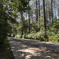
Gerhagen Nature Park
Trasa rowerowa rozpoczynająca się w Diest, Region Flamandzki, Belgia.
Przegląd
O tej trasie
You cycle through the beautiful and varied landscape of Gerhagen Nature Park. This quiet area consists largely of forest. In the lower part there are also meadows and fields. In the area you will find the fens of the Pinnekensweier nature reserve and the De Houterenberg nature reserve with its forests, heather and drifting sands. The nightjar breeds in the trees and you can hear the tree lark singing. At the bottom you will find the swamp wolf claw, sundew and the brown and white beak rush, as well as many other plants that thrive here. At Bosmuseum Gerhagen there is a lookout tower of almost 19 meters high. Anyone who dares the climb will be rewarded with a magnificent view of the entire area.
Norbertine Abbey or Postel Abbey, from 1140, is a Norbertine abbey. A community of priests and brothers lives together according to Augustine's monastic rule. The abbey has an extensive library with 100,000 works and is also known for its cheese production and herb garden. You can take a guided tour on Sundays and public holidays. The Norbertines of Postel brewed beer from 1611, but today the Abbey beer Postel is no longer brewed in the abbey itself.
At Genenbos you come to the Albert Canal. You follow the canal to Tervant, after which you cycle around the Paalse Plas. This lake was once created by sand extraction and is now a recreational lake.
- -:--
- Czas
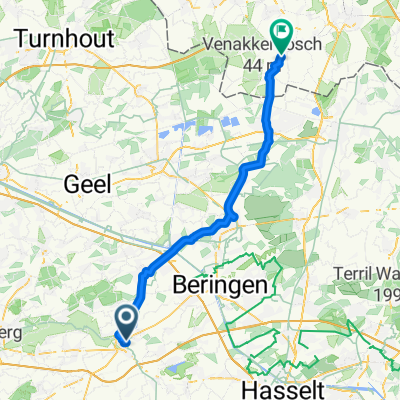
- 52,3 km
- Dystans
- 269 m
- Przewyższenia
- 270 m
- Spadek
- ---
- Śr. Prędkość
- ---
- Maks. wysokość

Jakość trasy
Typy dróg i nawierzchnie na trasie
Typy dróg
Spokojna droga
25,9 km
(50 %)
Droga rowerowa
15,5 km
(30 %)
Powierzchnie
Utwardzona
29,5 km
(56 %)
Nieutwardzona
2,4 km
(5 %)
Asfalt
22,4 km
(43 %)
Beton
4,5 km
(9 %)
Kontynuuj z Bikemap
Użyj, edytuj lub pobierz tę trasę rowerową
Chcesz przejechać trasę Gerhagen Nature Park lub dostosować ją do swojej wycieczki? Oto, co możesz zrobić z tą trasą na Bikemap:
Darmowe funkcje
- Zapisz tę trasę jako ulubioną lub w kolekcji
- Skopiuj i zaplanuj swoją wersję tej trasy
- Synchronizuj swoją trasę z Garminem lub Wahoo
Funkcje Premium
3 dni bezpłatnej wersji próbnej lub jednorazowa opłata. Dowiedz się więcej o Bikemap Premium.
- Nawiguj po tej trasie na iOS i Androidzie
- Eksportuj plik GPX / KML tej trasy
- Stwórz swój własny wydruk (wypróbuj za darmo)
- Pobierz tę trasę do nawigacji offline
Odkryj więcej funkcji Premium.
Uzyskaj Bikemap PremiumOd naszej społeczności
Diest: Inne popularne trasy rozpoczynające się tutaj
 MTB Diest • blauwe-rode lus Diest
- Dystans
- 48 km
- Przewyższenia
- 421 m
- Spadek
- 418 m
- Lokalizacja
- Diest, Region Flamandzki, Belgia
 VBV zomerfietsroute '08: Kempen/Hageland
- Dystans
- 32,7 km
- Przewyższenia
- 142 m
- Spadek
- 142 m
- Lokalizacja
- Diest, Region Flamandzki, Belgia
 DEMER_ZICH_DIEST
- Dystans
- 30,7 km
- Przewyższenia
- 109 m
- Spadek
- 106 m
- Lokalizacja
- Diest, Region Flamandzki, Belgia
 fietsroute for those who don’t skydive
- Dystans
- 67,8 km
- Przewyższenia
- 231 m
- Spadek
- 235 m
- Lokalizacja
- Diest, Region Flamandzki, Belgia
 Halen - Comblain-au-Pont
- Dystans
- 124,3 km
- Przewyższenia
- 1228 m
- Spadek
- 1169 m
- Lokalizacja
- Diest, Region Flamandzki, Belgia
 MTB diest rode lus 30km
- Dystans
- 30,9 km
- Przewyższenia
- 302 m
- Spadek
- 305 m
- Lokalizacja
- Diest, Region Flamandzki, Belgia
 Diest to Loo
- Dystans
- 50,3 km
- Przewyższenia
- 119 m
- Spadek
- 113 m
- Lokalizacja
- Diest, Region Flamandzki, Belgia
 50 KM ride
- Dystans
- 39,5 km
- Przewyższenia
- 256 m
- Spadek
- 251 m
- Lokalizacja
- Diest, Region Flamandzki, Belgia
Otwórz ją w aplikacji