

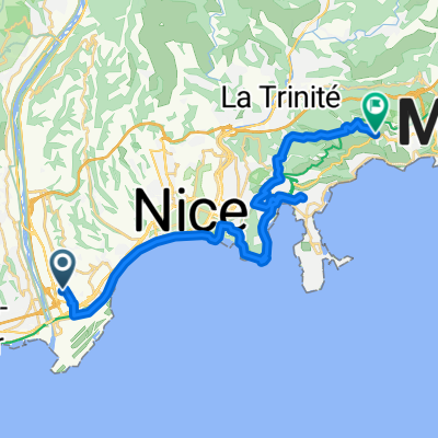
De 18 Avenue du Docteur Émile Roux, Nice à 1 Calada Auguste Escoffier, Nice
Trasa rowerowa rozpoczynająca się w Saint-Laurent-du-Var, Prowansja-Alpy-Lazurowe Wybrzeże, Francja.
Przegląd
O tej trasie
- 50 min
- Czas
- 13,6 km
- Dystans
- 0 m
- Przewyższenia
- 10 m
- Spadek
- 16,2 km/h
- Śr. Prędkość
- ---
- Maks. wysokość

Zdjęcia trasy


Kontynuuj z Bikemap
Użyj, edytuj lub pobierz tę trasę rowerową
Chcesz przejechać trasę De 18 Avenue du Docteur Émile Roux, Nice à 1 Calada Auguste Escoffier, Nice lub dostosować ją do swojej wycieczki? Oto, co możesz zrobić z tą trasą na Bikemap:
Darmowe funkcje
- Zapisz tę trasę jako ulubioną lub w kolekcji
- Skopiuj i zaplanuj swoją wersję tej trasy
- Synchronizuj swoją trasę z Garminem lub Wahoo
Funkcje Premium
3 dni bezpłatnej wersji próbnej lub jednorazowa opłata. Dowiedz się więcej o Bikemap Premium.
- Nawiguj po tej trasie na iOS i Androidzie
- Eksportuj plik GPX / KML tej trasy
- Stwórz swój własny wydruk (wypróbuj za darmo)
- Pobierz tę trasę do nawigacji offline
Odkryj więcej funkcji Premium.
Uzyskaj Bikemap PremiumOd naszej społeczności
Saint-Laurent-du-Var: Inne popularne trasy rozpoczynające się tutaj
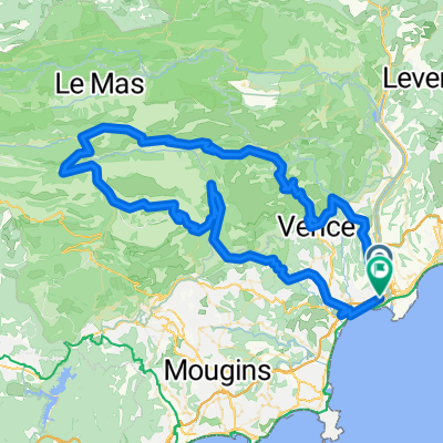
 Avenue de la Méditerranée, Nice à Avenue de Verdun, Èze
- Dystans
- 28,1 km
- Przewyższenia
- 1237 m
- Spadek
- 896 m
- Lokalizacja
- Saint-Laurent-du-Var, Prowansja-Alpy-Lazurowe Wybrzeże, Francja
 fatto_118_1975_patrikfroment_st laurent du var, vence, col de vence, greolieres, thorenc, col du castellaras, col de la sine, col de lecre, Caussols...
- Dystans
- 117,2 km
- Przewyższenia
- 1924 m
- Spadek
- 1919 m
- Lokalizacja
- Saint-Laurent-du-Var, Prowansja-Alpy-Lazurowe Wybrzeże, Francja
 FRANCIA_124_2101_Sortie longue ride 🚲 st laurent du var, moyenne corniche les pugets, vence , col de vence, greolieres, thorenc village, col de castellaras...
- Dystans
- 123,2 km
- Przewyższenia
- 2033 m
- Spadek
- 2027 m
- Lokalizacja
- Saint-Laurent-du-Var, Prowansja-Alpy-Lazurowe Wybrzeże, Francja
 Southern French Alps 2004 stage 0
- Dystans
- 37,6 km
- Przewyższenia
- 540 m
- Spadek
- 525 m
- Lokalizacja
- Saint-Laurent-du-Var, Prowansja-Alpy-Lazurowe Wybrzeże, Francja
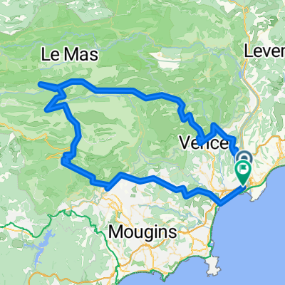
 Allée Anne Frank, Nice à Allée Hector Pintus, La Gaude
- Dystans
- 44,9 km
- Przewyższenia
- 1103 m
- Spadek
- 817 m
- Lokalizacja
- Saint-Laurent-du-Var, Prowansja-Alpy-Lazurowe Wybrzeże, Francja
 MCD Urlaub 2009 - Teil 1 - Tag 1-9
- Dystans
- 993,1 km
- Przewyższenia
- 1720 m
- Spadek
- 1494 m
- Lokalizacja
- Saint-Laurent-du-Var, Prowansja-Alpy-Lazurowe Wybrzeże, Francja
 Nizza-Manosque
- Dystans
- 186 km
- Przewyższenia
- 1316 m
- Spadek
- 997 m
- Lokalizacja
- Saint-Laurent-du-Var, Prowansja-Alpy-Lazurowe Wybrzeże, Francja
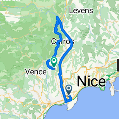
 E1-ColTurini
- Dystans
- 56,6 km
- Przewyższenia
- 1702 m
- Spadek
- 99 m
- Lokalizacja
- Saint-Laurent-du-Var, Prowansja-Alpy-Lazurowe Wybrzeże, Francja
Otwórz ją w aplikacji