

l'Ardèche fleurie
Trasa rowerowa rozpoczynająca się w Saint-Vallier, Owernia-Rodan-Alpy, Francja.
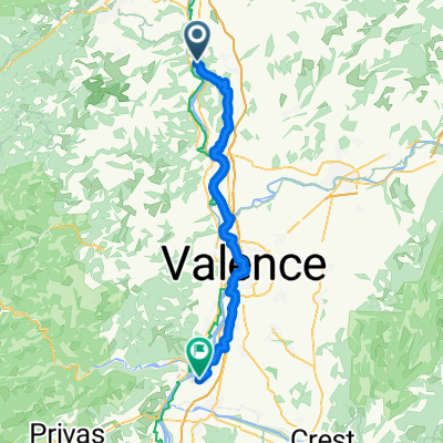
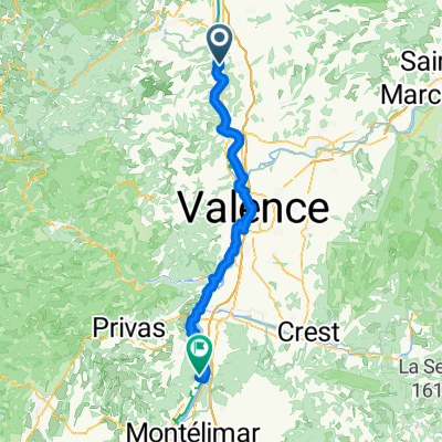
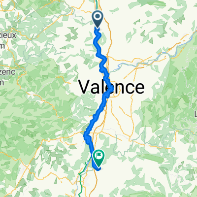
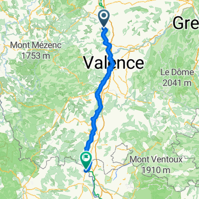
Przegląd
O tej trasie
Trasa prowadzi przez 'kol', kol de Juvenet, kol de Fontay, kol du Gibet, kol du Marchand, kol du Faux, kol du Buisson, Tracol, kol de Fontreyde, kol Perrier, kol de la combe de Beaune oraz kol de Nesson zanim wróci do Tain l'Hermitage.
Tain l'Hermitage do Lyon Part Dieu: 1 godzina i 6,90 euro.
- -:--
- Czas
- 113 km
- Dystans
- 1511 m
- Przewyższenia
- 1529 m
- Spadek
- ---
- Śr. Prędkość
- ---
- Maks. wysokość
Jakość trasy
Typy dróg i nawierzchnie na trasie
Typy dróg
Spokojna droga
39,6 km
(35 %)
Droga
14,7 km
(13 %)
Powierzchnie
Utwardzona
18,1 km
(16 %)
Nieutwardzona
1,1 km
(1 %)
Asfalt
18,1 km
(16 %)
Ziemia
1,1 km
(1 %)
Niezdefiniowany
93,8 km
(83 %)
Najważniejsze punkty trasy
Punkty zainteresowania na trasie
Interesujące miejsce po 23,6 km
Le col
Interesujące miejsce po 29,5 km
Col de Juvenet
Interesujące miejsce po 37,6 km
Col de Fontay
Interesujące miejsce po 44,9 km
Col du Gibet
Interesujące miejsce po 49,9 km
Col du marchand
Interesujące miejsce po 52 km
Col du Faux
Interesujące miejsce po 60,4 km
Col du Buisson
Interesujące miejsce po 64,8 km
Le tracol
Interesujące miejsce po 70,6 km
Col de Fontreyde
Interesujące miejsce po 81,1 km
Col Perrier
Interesujące miejsce po 96,6 km
Col de la Combe de Beaune
Interesujące miejsce po 108,4 km
Col de Nesson
Kontynuuj z Bikemap
Użyj, edytuj lub pobierz tę trasę rowerową
Chcesz przejechać trasę l'Ardèche fleurie lub dostosować ją do swojej wycieczki? Oto, co możesz zrobić z tą trasą na Bikemap:
Darmowe funkcje
- Zapisz tę trasę jako ulubioną lub w kolekcji
- Skopiuj i zaplanuj swoją wersję tej trasy
- Podziel trasę na etapy, aby utworzyć kilkudniową wycieczkę
- Synchronizuj swoją trasę z Garminem lub Wahoo
Funkcje Premium
3 dni bezpłatnej wersji próbnej lub jednorazowa opłata. Dowiedz się więcej o Bikemap Premium.
- Nawiguj po tej trasie na iOS i Androidzie
- Eksportuj plik GPX / KML tej trasy
- Stwórz swój własny wydruk (wypróbuj za darmo)
- Pobierz tę trasę do nawigacji offline
Odkryj więcej funkcji Premium.
Uzyskaj Bikemap PremiumOd naszej społeczności
Saint-Vallier: Inne popularne trasy rozpoczynające się tutaj
 Tour de France 2016 dzień 17
- Dystans
- 91,8 km
- Przewyższenia
- 1134 m
- Spadek
- 983 m
- Lokalizacja
- Saint-Vallier, Owernia-Rodan-Alpy, Francja
 Saint-Vallier - Beauchastel
- Dystans
- 58 km
- Przewyższenia
- 139 m
- Spadek
- 181 m
- Lokalizacja
- Saint-Vallier, Owernia-Rodan-Alpy, Francja
 St vallier à Cruas
- Dystans
- 86,1 km
- Przewyższenia
- 332 m
- Spadek
- 385 m
- Lokalizacja
- Saint-Vallier, Owernia-Rodan-Alpy, Francja
 l'Ardèche fleurie
- Dystans
- 113 km
- Przewyższenia
- 1511 m
- Spadek
- 1529 m
- Lokalizacja
- Saint-Vallier, Owernia-Rodan-Alpy, Francja
 De Rue de Verdun à La Serre
- Dystans
- 103,6 km
- Przewyższenia
- 429 m
- Spadek
- 391 m
- Lokalizacja
- Saint-Vallier, Owernia-Rodan-Alpy, Francja
 Entwurf: L'Allier-Tour
- Dystans
- 605,6 km
- Przewyższenia
- 7980 m
- Spadek
- 7948 m
- Lokalizacja
- Saint-Vallier, Owernia-Rodan-Alpy, Francja
 Saint-Vallier - Orange
- Dystans
- 140,7 km
- Przewyższenia
- 466 m
- Spadek
- 558 m
- Lokalizacja
- Saint-Vallier, Owernia-Rodan-Alpy, Francja
 Saint-Vallier - Alès - juillet 2024
- Dystans
- 530,8 km
- Przewyższenia
- 21 756 m
- Spadek
- 21 762 m
- Lokalizacja
- Saint-Vallier, Owernia-Rodan-Alpy, Francja
Otwórz ją w aplikacji