
Radtour21
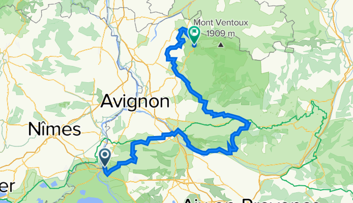
Provence_KN_21_1_Malaucene
Trasa rowerowa rozpoczynająca się w Arles, Prowansja-Alpy-Lazurowe Wybrzeże, Francja.
Przegląd
O tej trasie
- -:--
- Czas
- 212,9 km
- Dystans
- 1898 m
- Przewyższenia
- 1579 m
- Spadek
- ---
- Śr. Prędkość
- 603 m
- Maks. wysokość

Część
Radtour21
3 etapy
Jakość trasy
Typy dróg i nawierzchnie na trasie
Typy dróg
Droga
80,9 km
(38 %)
Spokojna droga
72,4 km
(34 %)
Powierzchnie
Utwardzona
115 km
(54 %)
Nieutwardzona
19,2 km
(9 %)
Asfalt
115 km
(54 %)
Żwir
14,9 km
(7 %)
Najważniejsze punkty trasy
Punkty zainteresowania na trasie
Interesujące miejsce po 24,1 km
Interesujące miejsce po 33,8 km
Interesujące miejsce po 57 km
Interesujące miejsce po 57 km
Interesujące miejsce po 96 km
Interesujące miejsce po 102 km
Interesujące miejsce po 118,7 km
Interesujące miejsce po 121,1 km
Interesujące miejsce po 130 km
Interesujące miejsce po 141 km
Interesujące miejsce po 166,9 km
Interesujące miejsce po 185 km
Interesujące miejsce po 201,5 km
Interesujące miejsce po 212,6 km
Kontynuuj z Bikemap
Użyj, edytuj lub pobierz tę trasę rowerową
Chcesz przejechać trasę Provence_KN_21_1_Malaucene lub dostosować ją do swojej wycieczki? Oto, co możesz zrobić z tą trasą na Bikemap:
Darmowe funkcje
- Zapisz tę trasę jako ulubioną lub w kolekcji
- Skopiuj i zaplanuj swoją wersję tej trasy
- Podziel trasę na etapy, aby utworzyć kilkudniową wycieczkę
- Synchronizuj swoją trasę z Garminem lub Wahoo
Funkcje Premium
3 dni bezpłatnej wersji próbnej lub jednorazowa opłata. Dowiedz się więcej o Bikemap Premium.
- Nawiguj po tej trasie na iOS i Androidzie
- Eksportuj plik GPX / KML tej trasy
- Stwórz swój własny wydruk (wypróbuj za darmo)
- Pobierz tę trasę do nawigacji offline
Odkryj więcej funkcji Premium.
Uzyskaj Bikemap PremiumOd naszej społeczności
Arles: Inne popularne trasy rozpoczynające się tutaj
 11.- De Arles a Montpellier (2)
- Dystans
- 77,7 km
- Przewyższenia
- 26 m
- Spadek
- 14 m
- Lokalizacja
- Arles, Prowansja-Alpy-Lazurowe Wybrzeże, Francja
 Etapa 089B (Arlés - Frontignan)
- Dystans
- 129,8 km
- Przewyższenia
- 235 m
- Spadek
- 239 m
- Lokalizacja
- Arles, Prowansja-Alpy-Lazurowe Wybrzeże, Francja
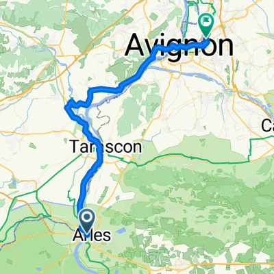
 Arles - Tarascon
- Dystans
- 19,3 km
- Przewyższenia
- 15 m
- Spadek
- 25 m
- Lokalizacja
- Arles, Prowansja-Alpy-Lazurowe Wybrzeże, Francja
 Arles - Nimes
- Dystans
- 34,4 km
- Przewyższenia
- 171 m
- Spadek
- 66 m
- Lokalizacja
- Arles, Prowansja-Alpy-Lazurowe Wybrzeże, Francja
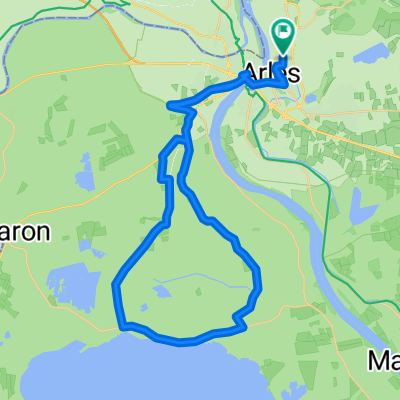 V. Arles - Camarque - Arles
- Dystans
- 48,9 km
- Przewyższenia
- 38 m
- Spadek
- 36 m
- Lokalizacja
- Arles, Prowansja-Alpy-Lazurowe Wybrzeże, Francja
 Rue Noguier, Arles to Avenue Victor Hugo, Le Pontet
- Dystans
- 59,3 km
- Przewyższenia
- 305 m
- Spadek
- 291 m
- Lokalizacja
- Arles, Prowansja-Alpy-Lazurowe Wybrzeże, Francja
 Rhone 1/7
- Dystans
- 114,8 km
- Przewyższenia
- 49 m
- Spadek
- 60 m
- Lokalizacja
- Arles, Prowansja-Alpy-Lazurowe Wybrzeże, Francja
 Arles_Camargue
- Dystans
- 50,1 km
- Przewyższenia
- 8 m
- Spadek
- 9 m
- Lokalizacja
- Arles, Prowansja-Alpy-Lazurowe Wybrzeże, Francja
Otwórz ją w aplikacji