

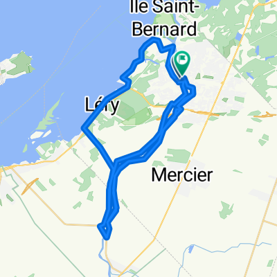
Le Parcours de la Vallée de la Châteauguay
Trasa rowerowa rozpoczynająca się w Châteauguay, Québec, Kanada.
Przegląd
O tej trasie
Plus qu’un simple trajet de 177 km sillonnent le Haut-Saint-Laurent, le Parcours de la Vallée de la Châteauguay est un séjour de pure évasion à 2 pas de Montréal. Vous serez immédiatement charmé par ses paysages champêtres, ses panoramas à perte de vue et ses nombreux trésors. La région du Haut-Saint-Laurent vous réserve mille et un secret à découvrir!
- -:--
- Czas
- 170,9 km
- Dystans
- 393 m
- Przewyższenia
- 374 m
- Spadek
- ---
- Śr. Prędkość
- ---
- Maks. wysokość
Jakość trasy
Typy dróg i nawierzchnie na trasie
Typy dróg
Droga
149,5 km
(87 %)
Ruchliwa droga
10,8 km
(6 %)
Powierzchnie
Utwardzona
68,9 km
(40 %)
Nieutwardzona
0,2 km
(<1 %)
Asfalt
51 km
(30 %)
Nawierzchnia (nieokreślona)
16,7 km
(10 %)
Najważniejsze punkty trasy
Punkty zainteresowania na trasie
Interesujące miejsce po 0,5 km
Navette fluviale Lac Saint-Louis
Interesujące miejsce po 16,3 km
Salle de spectacle et de réception Le Vieux Sainte-Martine
Interesujące miejsce po 16,6 km
A la découverte de la Châteauguay
Interesujące miejsce po 30,5 km
Lieu Historique National du Canada de la Bataille-de-la-Châteauguay
Interesujące miejsce po 36,9 km
Marché public de Ormstown
Interesujące miejsce po 37,2 km
Les Galeries Ormstown
Interesujące miejsce po 37,2 km
Ormstown, le village des antiquaires
Interesujące miejsce po 41,8 km
Gîte Centaure
Interesujące miejsce po 54,3 km
Kayak Safari
Interesujące miejsce po 54,4 km
Marché fermier du comté de Huntingdon
Interesujące miejsce po 54,7 km
Salle culturelle et communautaire Alfred-Langevin
Interesujące miejsce po 68,9 km
Auberge et Motels Rod and Gun
Interesujące miejsce po 71,7 km
Camping le Dauphin
Interesujące miejsce po 71,7 km
Église de Saint-Anicet
Interesujące miejsce po 74,7 km
Interesujące miejsce po 78 km
Réserve nationale de faune du lac Saint-François
Interesujące miejsce po 99,3 km
Pont couvert de Powerscourt
Interesujące miejsce po 112,1 km
Cidrerie Rockburn, les vergers Frier
Interesujące miejsce po 116,5 km
Ferme Hillspring
Interesujące miejsce po 118,5 km
Cidrerie la Pommeraie du Suroît
Interesujące miejsce po 118,7 km
Verger Blair Orchards
Interesujące miejsce po 122,2 km
Verger McMillan
Interesujące miejsce po 123 km
Manoir Bagnel-Hall
Interesujące miejsce po 123,6 km
Bleutière Benoit et Mario Faille
Interesujące miejsce po 123,6 km
Camping Lac des Pins
Interesujące miejsce po 123,6 km
Verger du Pirate
Interesujące miejsce po 124,7 km
Boulangerie Chartrand
Interesujące miejsce po 124,9 km
Verger Franklin
Interesujące miejsce po 125,1 km
Au verger du Clocher
Interesujące miejsce po 125,3 km
Gîte au Petit Ruisseau
Interesujące miejsce po 128,2 km
Brasserie Saint-Antoine-Abbé, miellerie, hydromellerie
Interesujące miejsce po 130,5 km
Le Lavandou
Interesujące miejsce po 135,2 km
Camping domaine de la Frontière Enchantée
Interesujące miejsce po 135,5 km
Vignoble du Marathonien
Interesujące miejsce po 147,3 km
Le Moulin de Capucine
Interesujące miejsce po 148,6 km
Alpagas des Hauts Vents
Interesujące miejsce po 153,4 km
L'Hermine cabane a sucre
Interesujące miejsce po 153,4 km
Camping Russeltown
Interesujące miejsce po 162,9 km
Gîte Rivers Edge B&B
Kontynuuj z Bikemap
Użyj, edytuj lub pobierz tę trasę rowerową
Chcesz przejechać trasę Le Parcours de la Vallée de la Châteauguay lub dostosować ją do swojej wycieczki? Oto, co możesz zrobić z tą trasą na Bikemap:
Darmowe funkcje
- Zapisz tę trasę jako ulubioną lub w kolekcji
- Skopiuj i zaplanuj swoją wersję tej trasy
- Podziel trasę na etapy, aby utworzyć kilkudniową wycieczkę
- Synchronizuj swoją trasę z Garminem lub Wahoo
Funkcje Premium
3 dni bezpłatnej wersji próbnej lub jednorazowa opłata. Dowiedz się więcej o Bikemap Premium.
- Nawiguj po tej trasie na iOS i Androidzie
- Eksportuj plik GPX / KML tej trasy
- Stwórz swój własny wydruk (wypróbuj za darmo)
- Pobierz tę trasę do nawigacji offline
Odkryj więcej funkcji Premium.
Uzyskaj Bikemap PremiumOd naszej społeczności
Châteauguay: Inne popularne trasy rozpoczynające się tutaj
 132 Rue Henriette-Caron, Châteauguay to 169 Rue Principale, Saint-Louis-de-Gonzague
- Dystans
- 31,1 km
- Przewyższenia
- 10 m
- Spadek
- 0 m
- Lokalizacja
- Châteauguay, Québec, Kanada
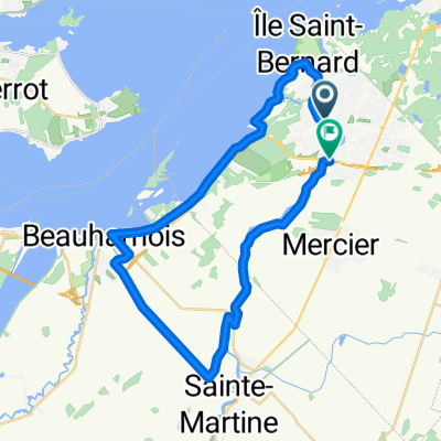
 Chateauguay-Ormstown 109km
- Dystans
- 109,9 km
- Przewyższenia
- 49 m
- Spadek
- 47 m
- Lokalizacja
- Châteauguay, Québec, Kanada
 Chateaugay-St-Louis de Gonzague-Beauharnois
- Dystans
- 75,7 km
- Przewyższenia
- 51 m
- Spadek
- 51 m
- Lokalizacja
- Châteauguay, Québec, Kanada
 Itinéraire vers 500 Boul d'Youville, Châteauguay
- Dystans
- 41,7 km
- Przewyższenia
- 83 m
- Spadek
- 88 m
- Lokalizacja
- Châteauguay, Québec, Kanada
 ced route 2
- Dystans
- 39,9 km
- Przewyższenia
- 51 m
- Spadek
- 51 m
- Lokalizacja
- Châteauguay, Québec, Kanada
 Chautauguay(Circuit de la rivière Châtauguay)
- Dystans
- 56,3 km
- Przewyższenia
- 79 m
- Spadek
- 76 m
- Lokalizacja
- Châteauguay, Québec, Kanada
 186 Rue de Liège, Châteauguay to 184 Rue de Liège, Châteauguay
- Dystans
- 42 km
- Przewyższenia
- 106 m
- Spadek
- 104 m
- Lokalizacja
- Châteauguay, Québec, Kanada
 Boulevard D'Youville 5, Châteauguay to Rue des Sittelles 200, Châteauguay
- Dystans
- 38,7 km
- Przewyższenia
- 170 m
- Spadek
- 172 m
- Lokalizacja
- Châteauguay, Québec, Kanada
Otwórz ją w aplikacji