![[Trek] V 52 - La véloroute de la Marne](/_next/static/media/contour-lines-light-small.cafd5e5d.avif)
![[Trek] V 52 - La véloroute de la Marne](https://media.bikemap.net/routes/9771421/staticmaps/in_317a5de9-720f-4c03-bc70-65e5e17f67de_694x400_bikemap-2021-3D-static.png)
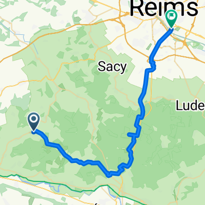
[Trek] V 52 - La véloroute de la Marne
Trasa rowerowa rozpoczynająca się w Châtillon-sur-Marne, Grand Est, Francja.
Przegląd
O tej trasie
From Dormans to Epernay, Marne flows between the foothills of the Montagne de Reims and the Côte des Blancs, which marks the eastern border of the Paris basin. in the wait of a new greenway to be developed, the route follows a section on preliminary automobile roads. The surrounding land fades gradually as we approach Chalons-en-Champagne. From the boat cruise you can see the "Venise Pétillante" before arriving to Vitry-le-François to follow a temporary route on a low traffic road.
Modified: 23 weeks ago
- -:--
- Czas
- 19,5 km
- Dystans
- 22 m
- Przewyższenia
- 18 m
- Spadek
- ---
- Śr. Prędkość
- 75 m
- Maks. wysokość

Jakość trasy
Typy dróg i nawierzchnie na trasie
Typy dróg
Spokojna droga
9,8 km
(50 %)
Ścieżka
7,9 km
(40 %)
Powierzchnie
Utwardzona
17,9 km
(92 %)
Nieutwardzona
0,2 km
(1 %)
Asfalt
16,6 km
(85 %)
Beton
1,4 km
(7 %)
Kontynuuj z Bikemap
Użyj, edytuj lub pobierz tę trasę rowerową
Chcesz przejechać trasę [Trek] V 52 - La véloroute de la Marne lub dostosować ją do swojej wycieczki? Oto, co możesz zrobić z tą trasą na Bikemap:
Darmowe funkcje
- Zapisz tę trasę jako ulubioną lub w kolekcji
- Skopiuj i zaplanuj swoją wersję tej trasy
- Synchronizuj swoją trasę z Garminem lub Wahoo
Funkcje Premium
3 dni bezpłatnej wersji próbnej lub jednorazowa opłata. Dowiedz się więcej o Bikemap Premium.
- Nawiguj po tej trasie na iOS i Androidzie
- Eksportuj plik GPX / KML tej trasy
- Stwórz swój własny wydruk (wypróbuj za darmo)
- Pobierz tę trasę do nawigacji offline
Odkryj więcej funkcji Premium.
Uzyskaj Bikemap PremiumOd naszej społeczności
Châtillon-sur-Marne: Inne popularne trasy rozpoczynające się tutaj
 "'(§è
"'(§è- Dystans
- 40 km
- Przewyższenia
- 389 m
- Spadek
- 485 m
- Lokalizacja
- Châtillon-sur-Marne, Grand Est, Francja
 Recovered Route
- Dystans
- 49,4 km
- Przewyższenia
- 882 m
- Spadek
- 897 m
- Lokalizacja
- Châtillon-sur-Marne, Grand Est, Francja
 vrijgezellenfeest Reims
- Dystans
- 37,4 km
- Przewyższenia
- 611 m
- Spadek
- 637 m
- Lokalizacja
- Châtillon-sur-Marne, Grand Est, Francja
 Binson-et-Orquigny
- Dystans
- 54,2 km
- Przewyższenia
- 522 m
- Spadek
- 521 m
- Lokalizacja
- Châtillon-sur-Marne, Grand Est, Francja
 Champagne plat
- Dystans
- 53,5 km
- Przewyższenia
- 367 m
- Spadek
- 369 m
- Lokalizacja
- Châtillon-sur-Marne, Grand Est, Francja
 Autour de Châtillon-sur-Marne
- Dystans
- 26,1 km
- Przewyższenia
- 438 m
- Spadek
- 439 m
- Lokalizacja
- Châtillon-sur-Marne, Grand Est, Francja
 Circuit du Chatillonais
- Dystans
- 25 km
- Przewyższenia
- 370 m
- Spadek
- 368 m
- Lokalizacja
- Châtillon-sur-Marne, Grand Est, Francja
![[Trek] V 52 - La véloroute de la Marne](https://media.bikemap.net/routes/9771421/staticmaps/in_317a5de9-720f-4c03-bc70-65e5e17f67de_400x400_bikemap-2021-3D-static.png) [Trek] V 52 - La véloroute de la Marne
[Trek] V 52 - La véloroute de la Marne- Dystans
- 19,5 km
- Przewyższenia
- 22 m
- Spadek
- 18 m
- Lokalizacja
- Châtillon-sur-Marne, Grand Est, Francja
Otwórz ją w aplikacji