
Alpenpanorama-Route
Alpine Panorama Route (Switzerland)
Eine Sammlung von 18 Radtouren.
Übersicht
Über diese Sammlung
Große Aussichten, größere Anstiege. Die Alpine Panorama Route verbindet ruhige Nebenstraßen, Radwege und einige belebtere Verbindungsstrecken quer durch die Schweizer Voralpen. Sie ist ungefähr 475 km lang mit über 12.000 m Aufstieg, also erwarten dich stetige Anstiege, geschwungene Abfahrten und Postkartenmotive an jeder Kurve.
Du radelst vorbei an Seen, grünen Hügeln und klassischen Dörfern mit den Alpen am Horizont. Die Untergründe sind meist glatter Asphalt, mit kurzen Abschnitten Schotter, Kopfsteinpflaster und gelegentlich einer Holzbrücke – fahrbar mit einem Touren- oder Endurance-Rennrad. Bevorzugst du komplett asphaltierte Strecken? Umwege sind meist problemlos möglich.
Plane es als mehrtägige Tour: eine entspannte Woche, wenn du fit bist, länger, wenn du extra Kaffeepausen und Aussichtspunkte einplanst. Die Wegweisung ist simpel – folge den Route 4 Schildern – und es gibt häufige Zugverbindungen, falls du eine Etappe abkürzen oder aufgeben möchtest.
Am besten von Spätfrühling bis Herbst. Nimm Schichten für wechselhaftes Bergwetter mit und gute Bremsen für die langen Abfahrten. Wenn du lange Tage, ruhige Täler und Panorama-Himmel magst, ist das hier ein echter Geheimtipp.
- 18
- Routen
- -:--
- Dauer
- 476,1 km
- Distanz
- ---
- Ø-Tempo
- 12.617 m
- Aufstieg
- 12.773 m
- Abstieg
Alpine Panorama Route (Switzerland)
Routen in dieser Sammlung
Alle 18 Routen in dieser Sammlung können auf der Karte oder in der Bikemap App geöffnet werden, wo du sie im Routenplaner anpassen oder als GPX- oder KML-Datei herunterladen kannst. Nutze sie als Vorlage für die Planung deiner eigenen Fahrten oder lass dich von Bikemap direkt entlang der Routen navigieren.

Alpenpanorama-Route - Etappe 2
Fahrradtour in Gonten, Kanton Appenzell Innerrhoden, Schweiz
- 67,5 km
- Distanz
- 1.358 m
- Aufstieg
- 928 m
- Abstieg

Alpenpanorama-Route - Etappe 2
Fahrradtour in Appenzell, Kanton Appenzell Innerrhoden, Schweiz
- 5 km
- Distanz
- 3 m
- Aufstieg
- 125 m
- Abstieg

Alpenpanorama-Route: Teufen AR to Appenzell
Fahrradtour in Teufen AR, Kanton Appenzell Ausserrhoden, Schweiz
- 13,5 km
- Distanz
- 297 m
- Aufstieg
- 217 m
- Abstieg

Alpenpanorama-Route: Speicher – Teufen AR
Fahrradtour in Speicher AR, Kanton Appenzell Ausserrhoden, Schweiz
- 2 km
- Distanz
- 67 m
- Aufstieg
- 10 m
- Abstieg

Alpenpanorama-Route: Trogen - Sankt Margrethen
Fahrradtour in Trogen AR, Kanton Appenzell Ausserrhoden, Schweiz
- 30,4 km
- Distanz
- 699 m
- Aufstieg
- 1.204 m
- Abstieg

Alpenpanorama-Route - Etappe 3
Fahrradtour in Glarus, Kanton Glarus, Schweiz
- 64,2 km
- Distanz
- 2.320 m
- Aufstieg
- 2.324 m
- Abstieg

Alpenpanorama-Route - Etappe 3
Fahrradtour in Altdorf, Kanton Uri, Schweiz
- 4,1 km
- Distanz
- 0 m
- Aufstieg
- 33 m
- Abstieg

Alpenpanorama-Route: Bauen–Alpnach
Fahrradtour in Bauen, Kanton Uri, Schweiz
- 59,1 km
- Distanz
- 1.805 m
- Aufstieg
- 1.864 m
- Abstieg
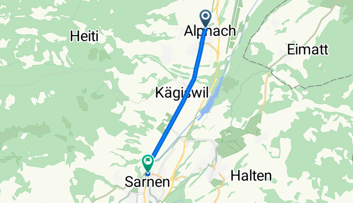
Alpenpanorama-Route: Alpnach–Sarnen
Fahrradtour in Alpnach, Kanton Obwalden, Schweiz
- 5,4 km
- Distanz
- 37 m
- Aufstieg
- 31 m
- Abstieg

Alpenpanorama-Route: Sachseln–Flühli
Fahrradtour in Sachseln, Kanton Obwalden, Schweiz
- 29,2 km
- Distanz
- 1.375 m
- Aufstieg
- 743 m
- Abstieg

Alpenpanorama-Route - Etappe 5
Fahrradtour in Thun, Kanton Bern, Schweiz
- 51,2 km
- Distanz
- 968 m
- Aufstieg
- 1.545 m
- Abstieg

Alpenpanorama-Route: Blumenstein to Thun
Fahrradtour in Blumenstein BE, Kanton Bern, Schweiz
- 10,6 km
- Distanz
- 130 m
- Aufstieg
- 45 m
- Abstieg