
Tårnby mit dem Fahrrad
Entdecke eine Karte mit 707 Radrouten und Radwegen rund um Tårnby, erstellt von unserer Community.
Regionenporträt
Lerne Tårnby kennen
Finde die richtige Fahrradroute in Tårnby, wo wir 707 Fahrradrouten für dich zum Erkunden haben. Die meisten Leute fahren hier in den Monaten Juli und August Fahrrad.
65.806 km
Aufgezeichnete Strecken
707
Fahrradrouten
10.000
Einwohner
Community
Die aktivsten Nutzer in Tårnby


Handverlesene Routen
Entdecke Tårnby durch diese Sammlungen
Tour
Tour
Von unserer Community
Die besten Fahrradrouten in und um Tårnby

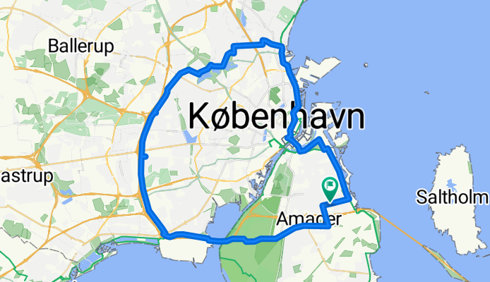
Round Amager 3
Fahrradtour in Tårnby, Hauptstadtregion, Dänemark
Without the nothern part
- 39,8 km
- Distanz
- 16 m
- Aufstieg
- 17 m
- Abstieg
Vestvolden rundt
Fahrradtour in Tårnby, Hauptstadtregion, Dänemark
Start and finish are at the Airport Dan Hotel
Mostly paved, but not 100%. Includes much of the very pleasant trail along the old westerly fortifications.
Bike path deviates R from Vejlands Alee @ Center Blvd; not well marked --- you DON'T have to use the bus lane; actual bike path is just north; separated by trees; quite nice
East to miss: Vestvolden route has the rider crossing Gammel Koge Landevej, turning right, then turning left after crossing the moat.
A seeming dead end into a RR track may be encountered if GPS set too far 'out' -- crossing is an underpass a couple humdred meters to the East
156 Roskildervej is crossed on a bike/ped bridge; trail cutoff is easy to miss
E47 Jyllingevej crossing is via a bike bridge with steps and a single wheel trough; too steep for some cargo bikes (eg Winther Kangaroo) to get through; bad for many trikes and velomobiles; unobstructed (but unprotected, uncontrolled and probably illegal) grade crosssing can be made less than 100m East
Trail dead-ends at rail line shortly before 211; back-track is short if you miss the turn-off to the bike overpass (gg) Label is "> Utterslev Mose"
Total was a bit over 36 miles when we did it (some detours)
(cloned from route 338766)
- 51,3 km
- Distanz
- 50 m
- Aufstieg
- 50 m
- Abstieg


CPH HOTEL -> PLANESPOTTING
Fahrradtour in Tårnby, Hauptstadtregion, Dänemark
- 8,7 km
- Distanz
- 46 m
- Aufstieg
- 32 m
- Abstieg

Mehr Routen entdecken
 Richard Mortensens Vej 73, København S to Richard Mortensens Vej 80, København S
- Distanz
- 29,4 km
- Aufstieg
- 73 m
- Abstieg
- 71 m
- Standort
- Tårnby, Hauptstadtregion, Dänemark
 Hvidovre turen
- Distanz
- 22,9 km
- Aufstieg
- 13 m
- Abstieg
- 14 m
- Standort
- Tårnby, Hauptstadtregion, Dänemark
 Vestvolden rundt langt
- Distanz
- 85,9 km
- Aufstieg
- 177 m
- Abstieg
- 178 m
- Standort
- Tårnby, Hauptstadtregion, Dänemark
 40 km rundt i StorKBH
- Distanz
- 39,7 km
- Aufstieg
- 59 m
- Abstieg
- 60 m
- Standort
- Tårnby, Hauptstadtregion, Dänemark
 Da Dæmningsvej, Copenaghen a Strandstien, Dragør
- Distanz
- 19,3 km
- Aufstieg
- 0 m
- Abstieg
- 3 m
- Standort
- Tårnby, Hauptstadtregion, Dänemark
 Airport to Bagsværd
- Distanz
- 31,8 km
- Aufstieg
- 40 m
- Abstieg
- 15 m
- Standort
- Tårnby, Hauptstadtregion, Dänemark
 AC Hotel to Helsingør
- Distanz
- 50,7 km
- Aufstieg
- 96 m
- Abstieg
- 95 m
- Standort
- Tårnby, Hauptstadtregion, Dänemark
 Rundt om havnen
- Distanz
- 23,5 km
- Aufstieg
- 13 m
- Abstieg
- 13 m
- Standort
- Tårnby, Hauptstadtregion, Dänemark
Routen von Tårnby
Kurze Fahrt mit dem Fahrrad von
Tårnby nach Christianshavn
Kurze Fahrt mit dem Fahrrad von
Tårnby nach Frederiksberg Kommune
Routen nach Tårnby
Kurze Fahrt mit dem Fahrrad von
Christianshavn nach Tårnby
Kurze Fahrt mit dem Fahrrad von
Frederiksberg Kommune nach Tårnby