
Galgate mit dem Fahrrad
Entdecke eine Karte mit 55 Radrouten und Radwegen rund um Galgate, erstellt von unserer Community.
Regionenporträt
Lerne Galgate kennen
Finde die richtige Fahrradroute in Galgate, wo wir 55 Fahrradrouten für dich zum Erkunden haben. Die meisten Leute fahren hier im Monat Mai Fahrrad.
2.160 km
Aufgezeichnete Strecken
55
Fahrradrouten
1.612
Einwohner
Community
Die aktivsten Nutzer in Galgate


Von unserer Community
Die besten Fahrradrouten in und um Galgate


Day 8, 37 hilly miles from Lancaster to Tockholes
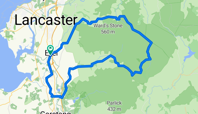
Fahrradtour in Galgate, England, Vereinigtes Königreich
- 58,4 km
- Distanz
- 660 m
- Aufstieg
- 458 m
- Abstieg

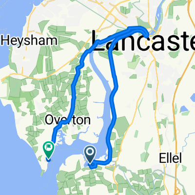
Glasson Dock to Grasmere
Fahrradtour in Galgate, England, Vereinigtes Königreich
- 83,6 km
- Distanz
- 465 m
- Aufstieg
- 400 m
- Abstieg
Chapel Lane 1, Galgate to Chapel Lane 1, Galgate
Fahrradtour in Galgate, England, Vereinigtes Königreich
- 65,3 km
- Distanz
- 881 m
- Aufstieg
- 880 m
- Abstieg

Glasson Gallimaufry
Fahrradtour in Galgate, England, Vereinigtes Königreich
- 39,2 km
- Distanz
- 42 m
- Aufstieg
- 41 m
- Abstieg
Mehr Routen entdecken
 Glasson Dock to Grasmere
- Distanz
- 83,6 km
- Aufstieg
- 463 m
- Abstieg
- 397 m
- Standort
- Galgate, England, Vereinigtes Königreich
 38m Ride home via Silverdale and Arnside
- Distanz
- 61,8 km
- Aufstieg
- 562 m
- Abstieg
- 547 m
- Standort
- Galgate, England, Vereinigtes Königreich
 Jeremy Lane to Tithebarn Hill 2, Glasson Dock
- Distanz
- 1,2 km
- Aufstieg
- 0 m
- Abstieg
- 0 m
- Standort
- Galgate, England, Vereinigtes Königreich
 Day 8 - Lancaster to Broughton-in-Furness
- Distanz
- 110,9 km
- Aufstieg
- 1.005 m
- Abstieg
- 1.051 m
- Standort
- Galgate, England, Vereinigtes Königreich
 bowland off orad evening/weekend-henry
- Distanz
- 27,6 km
- Aufstieg
- 708 m
- Abstieg
- 713 m
- Standort
- Galgate, England, Vereinigtes Königreich
 Fast ride in Lancaster
- Distanz
- 27,7 km
- Aufstieg
- 68 m
- Abstieg
- 66 m
- Standort
- Galgate, England, Vereinigtes Königreich
 Glasson Marina to Sunderland Point
- Distanz
- 19,6 km
- Aufstieg
- 67 m
- Abstieg
- 65 m
- Standort
- Galgate, England, Vereinigtes Königreich
 caton short
- Distanz
- 25,4 km
- Aufstieg
- 178 m
- Abstieg
- 177 m
- Standort
- Galgate, England, Vereinigtes Königreich