
Exeter mit dem Fahrrad
Entdecke eine Karte mit 447 Radrouten und Radwegen rund um Exeter, erstellt von unserer Community.
Regionenporträt
Lerne Exeter kennen
Finde die richtige Fahrradroute in Exeter, wo wir 447 Fahrradrouten für dich zum Erkunden haben. Die meisten Leute fahren hier in den Monaten Juli und August Fahrrad.
25.767 km
Aufgezeichnete Strecken
447
Fahrradrouten
113.118
Einwohner
Community
Die aktivsten Nutzer in Exeter


Handverlesene Routen
Entdecke Exeter durch diese Sammlungen
Tour

Von unserer Community
Die besten Fahrradrouten in und um Exeter

34km Ride – Gentle Hills and Peaceful Roads
Fahrradtour in Exeter, England, Vereinigtes Königreich
Enjoy a 34km ride on a mix of peaceful roads and dedicated cycle paths. Ideal for beginners, with easy navigation and gradual elevation changes. A great choice for new and experienced riders alike.
Start on the Exeter cycle paths, following any signage towards the "Science Park." Once across the Redhayes Bridge that goes over the M5, follow signs to the airport.
After Clyst Honiton, you will arrive at a roundabout—make sure to follow the cycle path into the airport car park to avoid the main road.
If you're in need of a coffee, you can turn right onto the shared cycle path when leaving the car park and head to "The Crusty Cob." Doing this will break up the 6km gentle climb from Clyst Honiton to Aylesbeare. (Edit: Crusty Cob is now closed)
If you prefer to push on, exit the airport car park and cross the road, heading past the airport entrance onto a quiet country road.
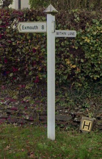
After heading through Westcott, follow signs to Aylesbeare. As you pass through Aylesbeare, there is a white signpost on the right for "Within Lane." At the end of Within Lane, take a left.
If you want to avoid poor road quality, turn right and then left at "The White Horse" pub. This is especially recommended if you're on a road bike or if the weather is bad. Otherwise, take care crossing the major road and continue straight, then turn right at the triangle.
Follow signs to "Woodbury." In Woodbury, there is a local shop and pub if refreshments are needed.
Near the centre of Woodbury, there is a small wooden sign for "Ebford, Exe Estuary Trail." This can easily be missed.
At the time of writing, as you enter Ebford, the brown signage for the "Exe Estuary Trail" is broken. Make sure to turn left as you see the first houses of Ebford.
Continue following signs for the "Exe Estuary Trail" until you see blue signs for "Topsham" or "Exeter." Towards the end of the ride, there are plenty of opportunities for food and drinks in Topsham and Exeter, making for a perfect post-ride stop.
- 34,1 km
- Distanz
- 210 m
- Aufstieg
- 212 m
- Abstieg

Shobrooke loop
Fahrradtour in Exeter, England, Vereinigtes Königreich
- 33,4 km
- Distanz
- 383 m
- Aufstieg
- 387 m
- Abstieg

Exeter, Dawlish, Ashcombe circuit
Fahrradtour in Exeter, England, Vereinigtes Königreich
A cracking ride. Predominantly the first part to Dawlish is fairly flat, then the hills begin as you climb through Ashcombe on to Haldon Hill you are treated to incredibly scenic and quiet lanes with stunning views especially as you traverse the top of Haldon past Belvedere Tower. Catch this on a summer's evening and with luck you'll be treated to a fantastic sunset
- 50,1 km
- Distanz
- 521 m
- Aufstieg
- 521 m
- Abstieg

Fantasy Tour of Britain - Day 4
Fahrradtour in Exeter, England, Vereinigtes Königreich
Fantasy Tour of Britain
Exeter - Dunkery Beacon
Mountain
185km
Wednesday Week 1
- 184,7 km
- Distanz
- 2.246 m
- Aufstieg
- 1.776 m
- Abstieg
Mehr Routen entdecken
 30 miles 2500ft
- Distanz
- 52,7 km
- Aufstieg
- 472 m
- Abstieg
- 486 m
- Standort
- Exeter, England, Vereinigtes Königreich
 Feniton-Silverton
- Distanz
- 57,9 km
- Aufstieg
- 410 m
- Abstieg
- 410 m
- Standort
- Exeter, England, Vereinigtes Königreich
 Exeter-Two Bridges-Chudleigh-Exeter
- Distanz
- 98,3 km
- Aufstieg
- 1.027 m
- Abstieg
- 1.032 m
- Standort
- Exeter, England, Vereinigtes Königreich
 Fosterville loop
- Distanz
- 47,7 km
- Aufstieg
- 553 m
- Abstieg
- 555 m
- Standort
- Exeter, England, Vereinigtes Königreich
 100 miles from the centre of exeter
- Distanz
- 160,3 km
- Aufstieg
- 695 m
- Abstieg
- 699 m
- Standort
- Exeter, England, Vereinigtes Königreich
 Humber loop
- Distanz
- 52,1 km
- Aufstieg
- 720 m
- Abstieg
- 726 m
- Standort
- Exeter, England, Vereinigtes Königreich
 Bikeroute for Sue
- Distanz
- 32,6 km
- Aufstieg
- 270 m
- Abstieg
- 216 m
- Standort
- Exeter, England, Vereinigtes Königreich
 Fernworthy circuit from Exeter
- Distanz
- 76,9 km
- Aufstieg
- 871 m
- Abstieg
- 871 m
- Standort
- Exeter, England, Vereinigtes Königreich
Routen von Exeter
Kurze Fahrt mit dem Fahrrad von
Exeter nach Heavitree
Routen nach Exeter
Kurze Fahrt mit dem Fahrrad von
Heavitree nach Exeter