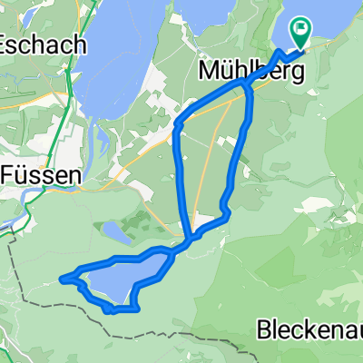
Wie Radfahren in Schwangau aussehen könnte.

Schwangau mit dem Fahrrad

Entdecke eine Karte mit 1.028 Radrouten und Radwegen rund um Schwangau, erstellt von unserer Community.

Regionenporträt

Lerne Schwangau kennen

Finde die richtige Fahrradroute in Schwangau, wo wir 1.028 Fahrradrouten für dich zum Erkunden haben. Die meisten Leute fahren hier in den Monaten Juni und Juli Fahrrad.

56.760 km

Aufgezeichnete Strecken

1.028

Fahrradrouten

3.505

Einwohner

Community

Die aktivsten Nutzer in Schwangau

Handverlesene Routen

Entdecke Schwangau durch diese Sammlungen

Dirk Lanzerath
Tour

2018 - Allgäu

4 Routen

riedgemse
Tour

Iller,Donau,Tauber,Main

Tour von riedgemse

13 Routen

Von unserer Community

Die besten Fahrradrouten in und um Schwangau

3-Seen-Tour
BefestigtUnbefestigtSchotter
9

3-Seen-Tour

Fahrradtour in Schwangau, Bayern, Deutschland

<span style="font-size: large;">Routenbeschreibung 3-Seen-Tour:</span> <span style="font-size: small;"><span style="text-decoration: none;"><span style="font-weight: normal;">Die Tour beginnt am </span></span><span style="text-decoration: none;">Campingplatz Bannwaldsee</span><span style="text-decoration: none;"><span style="font-weight: normal;">. </span></span><span style="text-decoration: none;"><span style="font-weight: normal;">Dort können </span></span><span style="text-decoration: none;"><span style="font-weight: normal;">Sie gegen eine kleine Gebühr (Preise variieren) E-Bikes oder auch normale Fah</span></span><span style="text-decoration: none;"><span style="font-weight: normal;">r</span></span><span style="text-decoration: none;"><span style="font-weight: normal;">räder ausleihen. Durchqueren Sie zunächst den Campingplatz, bis Sie links </span></span><span style="text-decoration: none;"><span style="font-weight: normal;">auf den</span></span><span style="text-decoration: none;"><span style="font-weight: normal;"> Wanderweg nach Schwangau gelangen. Dort </span></span><span style="text-decoration: none;"><span style="font-weight: normal;">geht es</span></span><span style="text-decoration: none;"><span style="font-weight: normal;"> geradeaus weiter in Richtung Schwangau, an der Brunner Ach entlang, bis Sie eine kleine Brücke erreichen. </span></span><span style="text-decoration: none;"><span style="font-weight: normal;">F</span></span><span style="text-decoration: none;"><span style="font-weight: normal;">ahren</span></span><span style="text-decoration: none;"><span style="font-weight: normal;"> Sie </span></span><span style="text-decoration: none;"><span style="font-weight: normal;">nach</span></span><span style="text-decoration: none;"><span style="font-weight: normal;"> rechts und </span></span><span style="text-decoration: none;"><span style="font-weight: normal;">anschließend</span></span><span style="text-decoration: none;"><span style="font-weight: normal;"> gleich wieder </span></span><span style="text-decoration: none;"><span style="font-weight: normal;">nach </span></span><span style="text-decoration: none;"><span style="font-weight: normal;">links, </span></span><span style="text-decoration: none;"><span style="font-weight: normal;">um </span></span><span style="text-decoration: none;"><span style="font-weight: normal;">in den Alemannenweg</span></span><span style="text-decoration: none;"><span style="font-weight: normal;"> zu gelangen</span></span><span style="text-decoration: none;"><span style="font-weight: normal;">. </span></span><span style="text-decoration: none;"><span style="font-weight: normal;">Der Fahrradweg führt schließlich vorbei an der </span></span><span style="text-decoration: none;">barocken Kirche St. Coloman</span><span style="text-decoration: none;"><span style="font-weight: normal;">, </span></span><span style="text-decoration: none;"><span style="font-weight: normal;">der</span></span><span style="text-decoration: none;"><span style="font-weight: normal;"> auch ein</span></span><span style="text-decoration: none;"><span style="font-weight: normal;">en herrlichen Ausblick auf die beiden </span></span><span style="text-decoration: none;">Köngisschlösser Neuschwanstein und Hohenschwangau</span><span style="text-decoration: none;"><span style="font-weight: normal;"> </span></span><span style="text-decoration: none;"><span style="font-weight: normal;">bietet</span></span><span style="text-decoration: none;"><span style="font-weight: normal;">. </span></span></span> <span style="font-size: small;"><span style="text-decoration: none;"><span style="font-weight: normal;">Nach ca. 1km erreichen Sie Schwangau. </span></span><span style="text-decoration: none;"><span style="font-weight: normal;">F</span></span><span style="text-decoration: none;"><span style="font-weight: normal;">olgen </span></span><span style="text-decoration: none;"><span style="font-weight: normal;">Sie </span></span><span style="text-decoration: none;"><span style="font-weight: normal;">dem Straßenverlauf </span></span><span style="text-decoration: none;"><span style="font-weight: normal;">über Unterdorf und Mitteldorf</span></span><span style="text-decoration: none;"><span style="font-weight: normal;">, der Sie geradewegs </span></span><span style="text-decoration: none;"><span style="font-weight: normal;">am Ehberg entlang, an der </span></span><span style="text-decoration: none;">K</span><span style="text-decoration: none;">öniglichen Kristalltherme</span><span style="text-decoration: none;"><span style="font-weight: normal;">, </span></span><span style="text-decoration: none;"><span style="font-weight: normal;">vorbeiführt. </span></span><span style="text-decoration: none;"><span style="font-weight: normal;">Die Thermen- und Saunenlandschaft lädt zum entspannen ein. </span></span><span style="text-decoration: none;"><span style="font-weight: normal;">F</span></span><span style="text-decoration: none;"><span style="font-weight: normal;">ahren </span></span><span style="text-decoration: none;"><span style="font-weight: normal;">Sie</span></span><span style="text-decoration: none;"><span style="font-weight: normal;"> geradeaus weiter bis Sie das Hotel Rübezahl passiert haben </span></span><span style="text-decoration: none;"><span style="font-weight: normal;">und </span></span><span style="text-decoration: none;"><span style="font-weight: normal;">biegen Sie links in den Forchenweg ein, </span></span><span style="text-decoration: none;"><span style="font-weight: normal;">der über eine kleine Abfahrt </span></span><span style="text-decoration: none;"><span style="font-weight: normal;"> </span></span><span style="text-decoration: none;"><span style="font-weight: normal;">zur Lechstaustufe in Füssen</span></span><span style="text-decoration: none;"><span style="font-weight: normal;"> </span></span><span style="text-decoration: none;"><span style="font-weight: normal;">führt.</span></span><span style="text-decoration: none;"><span style="font-weight: normal;"> </span></span><span style="text-decoration: none;"><span style="font-weight: normal;">Hier queren Sie den Lech über eine Brücke </span></span><span style="text-decoration: none;"><span style="font-weight: normal;">und fahren anschließend nach</span></span><span style="text-decoration: none;"><span style="font-weight: normal;"> links </span></span><span style="text-decoration: none;"><span style="font-weight: normal;">einen kleinen Anstieg hinauf. Oben angekommen </span></span><span style="text-decoration: none;"><span style="font-weight: normal;">fahren Sie rechts und folgen der Ausschilderung „Bootshafen“</span></span><span style="text-decoration: none;"><span style="font-weight: normal;">. </span></span></span> <span style="font-size: small;"><span style="text-decoration: none;"><span style="font-weight: normal;">Links sehen nun die </span></span><span style="text-decoration: none;">Stadt Füssen</span><span style="text-decoration: none;"><span style="font-weight: normal;"> mit ihrer </span></span><span style="text-decoration: none;">historischen Altstadt</span><span style="text-decoration: none;"><span style="font-weight: normal;"> und dem </span></span><span style="text-decoration: none;">Hohen Schloss</span><span style="text-decoration: none;"><span style="font-weight: normal;">. </span></span><span style="text-decoration: none;"><span style="font-weight: normal;">Nach rund 2km entlang des Lechs erreichen </span></span><span style="text-decoration: none;"><span style="font-weight: normal;">Sie </span></span><span style="text-decoration: none;"><span style="font-weight: normal;">den Bootshafen und sehen</span></span><span style="text-decoration: none;"><span style="font-weight: normal;"> </span></span><span style="text-decoration: none;"><span style="font-weight: normal;">links</span></span><span style="text-decoration: none;"><span style="font-weight: normal;"> das Hotel Sommer. </span></span><span style="text-decoration: none;"><span style="font-weight: normal;">B</span></span><span style="text-decoration: none;"><span style="font-weight: normal;">iegen Sie nach rechts in die Weidachstr</span></span><span style="text-decoration: none;"><span style="font-weight: normal;">a</span></span><span style="text-decoration: none;"><span style="font-weight: normal;">ße ein und folgen </span></span><span style="text-decoration: none;"><span style="font-weight: normal;">Sie</span></span><span style="text-decoration: none;"><span style="font-weight: normal;"> dieser bis zu</span></span><span style="text-decoration: none;"><span style="font-weight: normal;">r nächsten</span></span><span style="text-decoration: none;"><span style="font-weight: normal;"> Kreuzung, </span></span><span style="text-decoration: none;"><span style="font-weight: normal;">an der</span></span><span style="text-decoration: none;"><span style="font-weight: normal;"> Sie</span></span><span style="text-decoration: none;"><span style="font-weight: normal;"> die zweite rechts Richtung Festspielhaus </span></span><span style="text-decoration: none;"><span style="font-weight: normal;">nehmen</span></span><span style="text-decoration: none;"><span style="font-weight: normal;">. Der </span></span><span style="text-decoration: none;"><span style="font-weight: normal;">Fahrradweg</span></span><span style="text-decoration: none;"><span style="font-weight: normal;"> führt rechts über eine Unterführung</span></span><span style="text-decoration: none;"><span style="font-weight: normal;"> einen kleinen Berg hinauf über die B16. An der nächsten Abzweigung fahren Sie links, </span></span><span style="text-decoration: none;"><span style="font-weight: normal;">anschließend </span></span><span style="text-decoration: none;"><span style="font-weight: normal;">gleich wieder rechts an der B16 entlang. Sie gelangen dann automatisch auf die Ehrwanger Straße.</span></span></span> <span style="font-size: small;"><span style="text-decoration: none;"><span style="font-weight: normal;">Geradeaus weiter führt der Weg</span></span><span style="text-decoration: none;"><span style="font-weight: normal;"> links am Wertstoffhof und der Kläranlage vorbei. Wenn Sie diese passiert haben, </span></span><span style="text-decoration: none;"><span style="font-weight: normal;">halten</span></span><span style="text-decoration: none;"><span style="font-weight: normal;"> Sie sich links. </span></span><span style="text-decoration: none;"><span style="font-weight: normal;">D</span></span><span style="text-decoration: none;"><span style="font-weight: normal;">ie</span></span><span style="text-decoration: none;"><span style="font-weight: normal;"> Str</span></span><span style="text-decoration: none;"><span style="font-weight: normal;">ecke </span></span><span style="text-decoration: none;"><span style="font-weight: normal;">verläuft</span></span><span style="text-decoration: none;"><span style="font-weight: normal;"> entlang des </span></span><span style="text-decoration: none;"><span style="font-weight: normal;">Forggenseeufer</span></span><span style="text-decoration: none;"><span style="font-weight: normal;">s.</span></span><span style="text-decoration: none;"><span style="font-weight: normal;"> Sie erreichen nach ca. 5 Minuten das </span></span><span style="text-decoration: none;">Café Maria</span><span style="text-decoration: none;"><span style="font-weight: normal;">, welches direkt am Ufer des Sees liegt. Machen Sie doch eine kleine Pause im </span></span><span style="text-decoration: none;">Biergarten</span><span style="text-decoration: none;"><span style="font-weight: normal;"> des Cafés und genießen Sie den wunderbaren </span></span><span style="text-decoration: none;">Ausblick auf die Alpen</span><span style="text-decoration: none;"><span style="font-weight: normal;"> und die Königsschlösser. </span></span></span> <span style="font-size: small;"><span style="text-decoration: none;"><span style="font-weight: normal;">Der Fahrradweg führt Sie w</span></span><span style="text-decoration: none;"><span style="font-weight: normal;">eiter </span></span><span style="text-decoration: none;"><span style="font-weight: normal;">auf d</span></span><span style="text-decoration: none;"><span style="font-weight: normal;">ie</span></span><span style="text-decoration: none;"><span style="font-weight: normal;"> Forggenseestraße, </span></span><span style="text-decoration: none;"><span style="font-weight: normal;">wo</span></span><span style="text-decoration: none;"><span style="font-weight: normal;"> </span></span><span style="text-decoration: none;"><span style="font-weight: normal;">Sie </span></span><span style="text-decoration: none;"><span style="font-weight: normal;">geradewegs auf </span></span><span style="text-decoration: none;"><span style="font-weight: normal;">das kleine Örtchen Osterreinen </span></span><span style="text-decoration: none;"><span style="font-weight: normal;">zusteuern</span></span><span style="text-decoration: none;"><span style="font-weight: normal;">. Nach etwa 200m erscheint rechts ein </span></span><span style="text-decoration: none;">Radlerhof</span><span style="text-decoration: none;"><span style="font-weight: normal;">. Dort können Sie – </span></span><span style="text-decoration: none;"><span style="font-weight: normal;">je nach Bedarf </span></span><span style="text-decoration: none;"><span style="font-weight: normal;">- Ihr </span></span><span style="text-decoration: none;">E-Bike wieder aufladen</span><span style="text-decoration: none;"><span style="font-weight: normal;">. </span></span></span> <span style="font-size: small;"><span style="text-decoration: none;"><span style="font-weight: normal;">Sie folgen dem Straßenverlauf, der Sie über</span></span><span style="text-decoration: none;"><span style="font-weight: normal;"> die Bachtalstraße </span></span><span style="text-decoration: none;"><span style="font-weight: normal;">aus dem Ort herausführt.</span></span><span style="text-decoration: none;"><span style="font-weight: normal;"> </span></span><span style="text-decoration: none;"><span style="font-weight: normal;">Sie </span></span><span style="text-decoration: none;"><span style="font-weight: normal;">erreichen</span></span><span style="text-decoration: none;"><span style="font-weight: normal;"> eine Kreuzung, an der Sie geradeaus </span></span><span style="text-decoration: none;"><span style="font-weight: normal;">weiter bis zur nächsten </span></span><span style="text-decoration: none;"><span style="font-weight: normal;">Abzweigung</span></span><span style="text-decoration: none;"><span style="font-weight: normal;"> fahren. </span></span><span style="text-decoration: none;"><span style="font-weight: normal;">Dort biegen Sie links ab Richtung </span></span><span style="text-decoration: none;">Tierschutzverein</span><span style="text-decoration: none;"><span style="font-weight: normal;"> und folgen dem Weg weiter geradeaus. Halten Sie sich nun rechts und folgen Sie den </span></span><span style="text-decoration: none;">Hinweisschildern des Forggensee-Rundwegs</span><span style="text-decoration: none;"><span style="font-weight: normal;">. </span></span><span style="text-decoration: none;"><span style="font-weight: normal;">Durch leicht ansteigendes Gelände</span></span><span style="text-decoration: none;"><span style="font-weight: normal;"> gelangen Sie nach Dietringen. </span></span><span style="text-decoration: none;"><span style="font-weight: normal;">F</span></span><span style="text-decoration: none;"><span style="font-weight: normal;">olgen Sie der Almstraße und biegen </span></span><span style="text-decoration: none;"><span style="font-weight: normal;">Sie etwa</span></span><span style="text-decoration: none;"><span style="font-weight: normal;"> in Ortsmitte</span></span><span style="text-decoration: none;"><span style="font-weight: normal;"> links in die Seestraße ein. </span></span><span style="text-decoration: none;"><span style="font-weight: normal;">Diese führt Sie </span></span><span style="text-decoration: none;"><span style="font-weight: normal;">ans</span></span><span style="text-decoration: none;"><span style="font-weight: normal;"> Forggenseeufer, </span></span><span style="text-decoration: none;"><span style="font-weight: normal;">wo Sie nach links weiterfahren. </span></span><span style="text-decoration: none;"><span style="font-weight: normal;">Gleich darauf biegen Sie</span></span><span style="text-decoration: none;"><span style="font-weight: normal;"> noch zweimal</span></span><span style="text-decoration: none;"><span style="font-weight: normal;"> links </span></span><span style="text-decoration: none;"><span style="font-weight: normal;">a</span></span><span style="text-decoration: none;"><span style="font-weight: normal;">b</span></span><span style="text-decoration: none;"><span style="font-weight: normal;">, um</span></span><span style="text-decoration: none;"><span style="font-weight: normal;"> zum Tiefental zu gelangen. </span></span><span style="text-decoration: none;"><span style="font-weight: normal;">Dort geht es rechts entlang der</span></span><span style="text-decoration: none;"><span style="font-weight: normal;"> B16 </span></span><span style="text-decoration: none;"><span style="font-weight: normal;">weiter </span></span><span style="text-decoration: none;"><span style="font-weight: normal;">nach Roßhaupten.</span></span><span style="text-decoration: none;"><span style="font-weight: normal;"> </span></span></span> <span style="font-size: small;"><span style="text-decoration: none;"><span style="font-weight: normal;">Nach etwa 1,</span></span><span style="text-decoration: none;"><span style="font-weight: normal;">5</span></span><span style="text-decoration: none;"><span style="font-weight: normal;">km sind sie dort</span></span><span style="text-decoration: none;"><span style="font-weight: normal;"> angekommen </span></span><span style="text-decoration: none;"><span style="font-weight: normal;">und </span></span><span style="text-decoration: none;"><span style="font-weight: normal;">folgen dem Fahrradweg, welcher nach rechts, in die Forggenseestraße führt. Sie </span></span><span style="text-decoration: none;"><span style="font-weight: normal;">folgen dem Straßenverlauf</span></span><span style="text-decoration: none;"><span style="font-weight: normal;"> entlang der OAL1. </span></span><span style="text-decoration: none;"><span style="font-weight: normal;">Nach ca. 2km gelangen Sie, vorbei am „</span></span><span style="text-decoration: none;">Kunstpark Via Claudia Augusta</span><span style="text-decoration: none;"><span style="font-weight: normal;">“, </span></span><span style="text-decoration: none;"><span style="font-weight: normal;">zur</span></span><span style="text-decoration: none;"><span style="font-weight: normal;"> </span></span><span style="text-decoration: none;">Staustufe des </span><span style="text-decoration: none;">Forggens</span><span style="text-decoration: none;">ees</span><span style="text-decoration: none;"><span style="font-weight: normal;">. </span></span><span style="text-decoration: none;"><span style="font-weight: normal;">Dessen Mauer staut den Lech zwischen Juni und Oktober auf. Im Winterhalbjahr führt der Lech wenig Wasser. Deshalb wird das Wasser des Forggensees in den Wintermonaten abgelassen. </span></span></span> <span style="font-size: small;"><span style="text-decoration: none;"><span style="font-weight: normal;">Sie lassen das Kraftwerk hinter sich. Jetzt geht es einen langgezogenen Anstieg an der westlichen Flanke des Illas-Bergs hinauf. Der herrliche Ausblick auf die Alpen entschädigt die Mühen des Anstiegs. </span></span><span style="text-decoration: none;"><span style="font-weight: normal;">Sie erreichen schließlich einen </span></span><span style="text-decoration: none;">Rastplatz </span><span style="text-decoration: none;">am Ufer des Illasbergsee</span><span style="text-decoration: none;">s</span><span style="text-decoration: none;"><span style="font-weight: normal;">. Genießen Sie doch die Ruhe und die schöne Landschaft auf einer der Ruhebänke. </span></span></span> <span style="font-size: small;"><span style="text-decoration: none;"><span style="font-weight: normal;">Weiter geht es </span></span><span style="text-decoration: none;"><span style="font-weight: normal;">einen kurzen, steilen Anstieg nach Kniebis hoch. </span></span><span style="text-decoration: none;"><span style="font-weight: normal;">Hinter dem Dorf wendet sich die Straße gen Süden und es folgt</span></span><span style="text-decoration: none;"><span style="font-weight: normal;"> eine Abfahrt, wo Sie sich vom vorherigen Anstieg wieder erholen können. Entlang der Hauptstraße endet der Radweg ca. 100 m nach Rauhenbichl, wo Sie nun die Hauptstraße überqueren, um auf den Fahrradweg auf der gegenüberliegenden Straßenseite zu gelangen. Dieser </span></span><span style="text-decoration: none;"><span style="font-weight: normal;">führt </span></span><span style="text-decoration: none;"><span style="font-weight: normal;">über die Illasbergstraße geradewegs nach Berghof hinein. </span></span><span style="text-decoration: none;"><span style="font-weight: normal;">Sie folgen dem Verlauf dieser Straße,</span></span><span style="text-decoration: none;"><span style="font-weight: normal;">um</span></span><span style="text-decoration: none;"><span style="font-weight: normal;"> rechts </span></span><span style="text-decoration: none;"><span style="font-weight: normal;">über </span></span><span style="text-decoration: none;"><span style="font-weight: normal;">eine Abfahrt hinunter nach Bayerniederhofen </span></span><span style="text-decoration: none;"><span style="font-weight: normal;">zu gelangen</span></span><span style="text-decoration: none;"><span style="font-weight: normal;">.</span></span><span style="text-decoration: none;"><span style="font-weight: normal;"> Dort angekommen halten Sie sich rechts und biegen in die Kirchstraße ein. </span></span><span style="text-decoration: none;"><span style="font-weight: normal;">Sie </span></span><span style="text-decoration: none;"><span style="font-weight: normal;">führt </span></span><span style="text-decoration: none;"><span style="font-weight: normal;">zu</span></span><span style="text-decoration: none;"><span style="font-weight: normal;"> einen </span></span><span style="text-decoration: none;">Kinderspielplatz</span><span style="text-decoration: none;"><span style="font-weight: normal;">, </span></span><span style="text-decoration: none;"><span style="font-weight: normal;">an dem S</span></span><span style="text-decoration: none;"><span style="font-weight: normal;">ie nach rechts abbiegen. </span></span></span> <span style="font-size: small;"><span style="text-decoration: none;"><span style="font-weight: normal;">Jetzt</span></span><span style="text-decoration: none;"><span style="font-weight: normal;"> geht es nur noch geradeaus, vorbei am </span></span><span style="text-decoration: none;">Buchenberg</span><span style="text-decoration: none;"><span style="font-weight: normal;"> und einem kleinen </span></span><span style="text-decoration: none;">Kneip</span><span style="text-decoration: none;">p</span><span style="text-decoration: none;">becken</span><span style="text-decoration: none;"><span style="font-weight: normal;"> am Ortsausgang von Buching. </span></span><span style="text-decoration: none;"><span style="font-weight: normal;">N</span></span><span style="text-decoration: none;"><span style="font-weight: normal;">ach etwa </span></span><span style="text-decoration: none;"><span style="font-weight: normal;">1,5km </span></span><span style="text-decoration: none;"><span style="font-weight: normal;">ist </span></span><span style="text-decoration: none;"><span style="font-weight: normal;">auch schon wieder der </span></span><span style="text-decoration: none;">Bannwaldsee</span><span style="text-decoration: none;"><span style="font-weight: normal;"> zu sehen. </span></span><span style="text-decoration: none;"><span style="font-weight: normal;">Entlang des Ufers</span></span><span style="text-decoration: none;"><span style="font-weight: normal;"> </span></span><span style="text-decoration: none;"><span style="font-weight: normal;">erreichen Sie schließlich wieder</span></span><span style="text-decoration: none;"><span style="font-weight: normal;"> den Campingplatz. </span></span></span>
32 km
Distanz
179 m
Aufstieg
179 m
Abstieg
Forggensee Runde mit Buchenberg (1140hm)
MTBBefestigtUnbefestigtSchotter
8

Forggensee Runde mit Buchenberg (1140hm)

Fahrradtour in Schwangau, Bayern, Deutschland

Abfahrt: Campingplatz Brunnen Schöne see Runde mit einem mittelschweren Aufstieg auf den Buchenberg. Anstieg ca. 350hm Oben gibt es auch eine Almhütte Fahrzeit ca. 4 stunden
46 km
Distanz
689 m
Aufstieg
678 m
Abstieg
FüssenLinderhof
MTBBefestigtUnbefestigtSchotter
4

FüssenLinderhof

Fahrradtour in Schwangau, Bayern, Deutschland

Von Hohenschwangau entlang der Pöllat bis Ammerwaldstraße, weiter nach Linderhof
21,7 km
Distanz
498 m
Aufstieg
531 m
Abstieg
Forchenweg 7, Schwangau nach Forchenweg 7, Schwangau
CitybikeBefestigtSchotter
Wolfgang Görlt
2

Forchenweg 7, Schwangau nach Forchenweg 7, Schwangau

Fahrradtour in Schwangau, Bayern, Deutschland

37,4 km
Distanz
297 m
Aufstieg
347 m
Abstieg

Mehr Routen entdecken