
Blue Ash mit dem Fahrrad
Entdecke eine Karte mit 18 Radrouten und Radwegen rund um Blue Ash, erstellt von unserer Community.
Regionenporträt
Lerne Blue Ash kennen
Finde die richtige Fahrradroute in Blue Ash, wo wir 18 Fahrradrouten für dich zum Erkunden haben.
196 km
Aufgezeichnete Strecken
18
Fahrradrouten
12.114
Einwohner
Community
Die aktivsten Nutzer in Blue Ash


Von unserer Community
Die besten Fahrradrouten in und um Blue Ash

14.5 miles from the Y
Fahrradtour in Blue Ash, Ohio, Vereinigte Staaten
- 23,3 km
- Distanz
- 204 m
- Aufstieg
- 203 m
- Abstieg

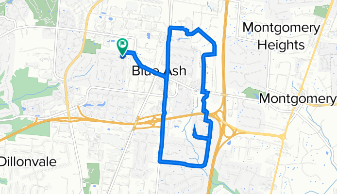
9675 Lansford Dr, Blue Ash to 9675 Lansford Dr, Blue Ash
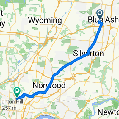
Fahrradtour in Blue Ash, Ohio, Vereinigte Staaten
- 8,1 km
- Distanz
- 41 m
- Aufstieg
- 49 m
- Abstieg

9700 Ridgeway Ave, Blue Ash to 9675 Lansford Dr, Blue Ash
Fahrradtour in Blue Ash, Ohio, Vereinigte Staaten
- 11,4 km
- Distanz
- 122 m
- Aufstieg
- 122 m
- Abstieg
Mehr Routen entdecken
 4555 Brown Ave, Blue Ash to 9675 Lansford Dr, Blue Ash
- Distanz
- 8 km
- Aufstieg
- 104 m
- Abstieg
- 105 m
- Standort
- Blue Ash, Ohio, Vereinigte Staaten
 5959 Hagewa Dr, Blue Ash to 8900–8948 Blossom Dr, Cincinnati
- Distanz
- 4,6 km
- Aufstieg
- 19 m
- Abstieg
- 20 m
- Standort
- Blue Ash, Ohio, Vereinigte Staaten
 9675 Lansford Dr, Blue Ash to 9675 Lansford Dr, Blue Ash
- Distanz
- 35,1 km
- Aufstieg
- 171 m
- Abstieg
- 169 m
- Standort
- Blue Ash, Ohio, Vereinigte Staaten
 9499 Wynnecrest Dr, Blue Ash to 4910 Hunt Rd, Blue Ash
- Distanz
- 14,9 km
- Aufstieg
- 80 m
- Abstieg
- 80 m
- Standort
- Blue Ash, Ohio, Vereinigte Staaten
 MS to Gd
- Distanz
- 2,2 km
- Aufstieg
- 4 m
- Abstieg
- 3 m
- Standort
- Blue Ash, Ohio, Vereinigte Staaten
 West Ave, Blue Ash to Vine St, Cincinnati
- Distanz
- 17,7 km
- Aufstieg
- 124 m
- Abstieg
- 173 m
- Standort
- Blue Ash, Ohio, Vereinigte Staaten
 9694 Lansford Dr, Blue Ash to 8794 Reading Rd, Reading
- Distanz
- 7,7 km
- Aufstieg
- 107 m
- Abstieg
- 205 m
- Standort
- Blue Ash, Ohio, Vereinigte Staaten
 Eagle Al, Blue Ash to 6846 Cooper Rd, Montgomery
- Distanz
- 3,8 km
- Aufstieg
- 16 m
- Abstieg
- 19 m
- Standort
- Blue Ash, Ohio, Vereinigte Staaten