
Burlington mit dem Fahrrad
Entdecke eine Karte mit 44 Radrouten und Radwegen rund um Burlington, erstellt von unserer Community.
Regionenporträt
Lerne Burlington kennen
Finde die richtige Fahrradroute in Burlington, wo wir 44 Fahrradrouten für dich zum Erkunden haben.
1.599 km
Aufgezeichnete Strecken
44
Fahrradrouten
8.388
Einwohner
Community
Die aktivsten Nutzer in Burlington


Von unserer Community
Die besten Fahrradrouten in und um Burlington


Burlington to Bellingham
Fahrradtour in Burlington, Washington, Vereinigte Staaten
The first half to two-thirds of the ride was pretty much flat through nice agricultural areas.
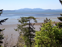
After the flat portion of the ride, we got onto Chuckanut Drive, which is really a beautiful road along the coast south of Bellingham that rises and falls a number of times. The only downsides are a little too much traffic, though not uncomfortably so for us, and the lack of road shoulder. There are a few lookout points, though with the trees below the lookout points growing up, the view of Puget Sound was nice, but not as panoramic as it would otherwise be.
Overall, great ride with good road conditions and nice countryside and views.
- 52,8 km
- Distanz
- 635 m
- Aufstieg
- 590 m
- Abstieg

Edison-SamishIsland20200728
Fahrradtour in Burlington, Washington, Vereinigte Staaten
Edison Elementary School to and around Samish Island. County park with beach access at north end of Wharf Street.
- 25 km
- Distanz
- 119 m
- Aufstieg
- 119 m
- Abstieg

2012 Skagit Spring Classic 45-Mile Route
Fahrradtour in Burlington, Washington, Vereinigte Staaten
Skagit Spring Classic 45-Mile Route
Starts at Bayview Elementary, through the farmland to Bow (25-milers turn west to head out to Bay View), up to Alger via Colony Road, back down via Friday Creek and Bow Hill, west to Bay View and back to Bay View Elementary.
- 75,9 km
- Distanz
- 254 m
- Aufstieg
- 254 m
- Abstieg

Mt. Constitution
Fahrradtour in Burlington, Washington, Vereinigte Staaten
Two nights on base of mountain and riding trails.
- 265 km
- Distanz
- 682 m
- Aufstieg
- 550 m
- Abstieg
Mehr Routen entdecken
 Bow-SedroWoolley-MtVernon-EdisonLoop20201121
- Distanz
- 68,7 km
- Aufstieg
- 206 m
- Abstieg
- 206 m
- Standort
- Burlington, Washington, Vereinigte Staaten
 Recording from September 18, 9:53 PM
- Distanz
- 7,8 km
- Aufstieg
- 8 m
- Abstieg
- 8 m
- Standort
- Burlington, Washington, Vereinigte Staaten
 Recording from September 18, 4:29 PM
- Distanz
- 12,1 km
- Aufstieg
- 0 m
- Abstieg
- 0 m
- Standort
- Burlington, Washington, Vereinigte Staaten
 Recording from October 24, 11:54 PM
- Distanz
- 7,6 km
- Aufstieg
- 9 m
- Abstieg
- 11 m
- Standort
- Burlington, Washington, Vereinigte Staaten
 5530 Chuckanut Dr, Bow to 14969 W Bow Hill Rd, Bow
- Distanz
- 47,1 km
- Aufstieg
- 761 m
- Abstieg
- 758 m
- Standort
- Burlington, Washington, Vereinigte Staaten
 Bow Cemetary-EdisonLoop
- Distanz
- 25,4 km
- Aufstieg
- 10 m
- Abstieg
- 10 m
- Standort
- Burlington, Washington, Vereinigte Staaten
 Recording from October 25, 12:35 AM
- Distanz
- 7,3 km
- Aufstieg
- 10 m
- Abstieg
- 8 m
- Standort
- Burlington, Washington, Vereinigte Staaten
 EdisonSchool-SamishIsland
- Distanz
- 20,5 km
- Aufstieg
- 62 m
- Abstieg
- 63 m
- Standort
- Burlington, Washington, Vereinigte Staaten