
Marietta-Alderwood mit dem Fahrrad
Entdecke eine Karte mit 12 Radrouten und Radwegen rund um Marietta-Alderwood, erstellt von unserer Community.
Regionenporträt
Lerne Marietta-Alderwood kennen
Finde die richtige Fahrradroute in Marietta-Alderwood, wo wir 12 Fahrradrouten für dich zum Erkunden haben.
542 km
Aufgezeichnete Strecken
12
Fahrradrouten
3.906
Einwohner
Community
Die aktivsten Nutzer in Marietta-Alderwood


Von unserer Community
Die besten Fahrradrouten in und um Marietta-Alderwood
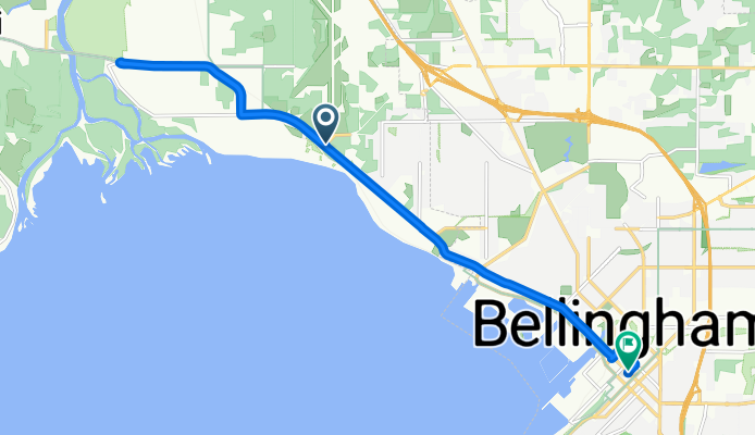
Marine Dr, Marietta to E Holly St, Bellingham
Fahrradtour in Marietta-Alderwood, Washington, Vereinigte Staaten
- 13,7 km
- Distanz
- 103 m
- Aufstieg
- 123 m
- Abstieg

Chuckanut Century North 2
Fahrradtour in Marietta-Alderwood, Washington, Vereinigte Staaten
- 74,2 km
- Distanz
- 304 m
- Aufstieg
- 328 m
- Abstieg

4623 Bedford Ave, Bellingham to 2858 W Maplewood Ave, Bellingham
Fahrradtour in Marietta-Alderwood, Washington, Vereinigte Staaten
- 6,8 km
- Distanz
- 117 m
- Aufstieg
- 124 m
- Abstieg

Airport Dr, Bellingham to 2858 W Maplewood Ave, Bellingham
Fahrradtour in Marietta-Alderwood, Washington, Vereinigte Staaten
- 33,5 km
- Distanz
- 393 m
- Aufstieg
- 414 m
- Abstieg
Mehr Routen entdecken
 Chuckanut Century North 2
- Distanz
- 74 km
- Aufstieg
- 284 m
- Abstieg
- 310 m
- Standort
- Marietta-Alderwood, Washington, Vereinigte Staaten
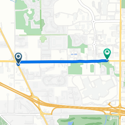
 3150 W Maplewood Ave, Bellingham to 1227 W Bakerview Rd, Bellingham
- Distanz
- 1,1 km
- Aufstieg
- 17 m
- Abstieg
- 7 m
- Standort
- Marietta-Alderwood, Washington, Vereinigte Staaten
 4260 Mitchell Way, Bellingham to 10 Lummi Key, Bellevue
- Distanz
- 174,8 km
- Aufstieg
- 627 m
- Abstieg
- 669 m
- Standort
- Marietta-Alderwood, Washington, Vereinigte Staaten
 Northwest Avenue to Meridian Street
- Distanz
- 1,9 km
- Aufstieg
- 16 m
- Abstieg
- 12 m
- Standort
- Marietta-Alderwood, Washington, Vereinigte Staaten
 Old Marine Dr, Marietta to Old Marine Dr, Marietta
- Distanz
- 32,5 km
- Aufstieg
- 114 m
- Abstieg
- 141 m
- Standort
- Marietta-Alderwood, Washington, Vereinigte Staaten
 Guide Meridian 4647, Bellingham to Portal Way 7080, Ferndale
- Distanz
- 17 km
- Aufstieg
- 47 m
- Abstieg
- 83 m
- Standort
- Marietta-Alderwood, Washington, Vereinigte Staaten
 Bellingham to Vancouver
- Distanz
- 106,5 km
- Aufstieg
- 1.505 m
- Abstieg
- 1.438 m
- Standort
- Marietta-Alderwood, Washington, Vereinigte Staaten
 Home Rd, Bellingham to E Holly St, Bellingham
- Distanz
- 5,9 km
- Aufstieg
- 41 m
- Abstieg
- 79 m
- Standort
- Marietta-Alderwood, Washington, Vereinigte Staaten