
Kurze Fahrt mit dem Fahrrad von Falcon Heights nach Minneapolis
Erstelle deine eigene Route auf der Grundlage unserer Vorlage oder lass dich inspirieren, wie unsere Nutzer am liebsten von Falcon Heights nach Minneapolis radeln.
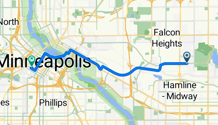
Routenvorlage
Falcon Heights nach Minneapolis

- 39 min
- Dauer
- 11,4 km
- Distanz
- 37 m
- Aufstieg
- 69 m
- Abstieg
- 17,8 km/h
- Ø-Tempo
- 289 m
- Max. Höhe
Schnapp dir dein Rad und genieße die entspannte Tour von Falcon Heights nach Minneapolis! Die rund 11,4 Kilometer lange Strecke schlängelt sich meist über gut ausgebaute Radwege (ganze 65 %!), sodass du entspannt rollen kannst. Mit wenig Steigung (nur etwa 37 Meter Anstieg) und etwas mehr Abfahrt wartet eine eher gemütliche Fahrt auf dich – besonders angenehm, wenn du ohne große Anstrengung in die City cruisen willst.
Los geht‘s in Falcon Heights, das als grüne Oase und Heimat der berühmten Minnesota State Fair bekannt ist. Mit viel Asphalt unter den Reifen (über 80 %!) kommst du auf überwiegend ruhigen Straßen und Radwegen durch Wohngebiete, Parks und Nähe zur Uni – zwischendurch bietet sich vielleicht ein kurzer Abstecher ins Grüne an.
Das Ziel: Minneapolis! Hier erwartet dich Urban-Vibes, hippe Cafés und natürlich grandiose Rad-Infrastruktur – kein Wunder, schließlich gilt die Stadt als Fahrrad-Hochburg des Mittleren Westens. Perfekt für den lockeren Tagesausflug oder den City-Trip auf zwei Rädern!
Community
Top-Mitglieder in dieser Region


Von unserer Community
Die besten Fahrradrouten von Falcon Heights nach Minneapolis

Memorial Ride - 10/04/08
Fahrradtour in Falcon Heights, Minnesota, Vereinigte Staaten
- 23 km
- Distanz
- 116 m
- Aufstieg
- 157 m
- Abstieg

B2B00017 - 55104 to 55402
Fahrradtour in Falcon Heights, Minnesota, Vereinigte Staaten
- 12,2 km
- Distanz
- 125 m
- Aufstieg
- 155 m
- Abstieg

B2B00715 55406 > 55402 via W River Pkwy, Midtown Greenway
Fahrradtour in Falcon Heights, Minnesota, Vereinigte Staaten
- 9,2 km
- Distanz
- 67 m
- Aufstieg
- 82 m
- Abstieg

B2B00116 55113>55406 via hoyt, intercampus transitway, river road, and 24th
Fahrradtour in Falcon Heights, Minnesota, Vereinigte Staaten
- 9,7 km
- Distanz
- 51 m
- Aufstieg
- 81 m
- Abstieg
B2B00180 55108>55402viaComo/Transitway/4thSE/Stonearch/2ndAV
Fahrradtour in Falcon Heights, Minnesota, Vereinigte Staaten
- 10,8 km
- Distanz
- 93 m
- Aufstieg
- 105 m
- Abstieg

B2B00346 55108 > 55401 via Hoyt, Transit Way, 5th St, Stone Arch
Fahrradtour in Falcon Heights, Minnesota, Vereinigte Staaten
- 12,3 km
- Distanz
- 74 m
- Aufstieg
- 88 m
- Abstieg

B2B00553 55108>55414 viaLarp/Hamline/Como/Intercampus/4thStSE/Main
Fahrradtour in Falcon Heights, Minnesota, Vereinigte Staaten
- 11 km
- Distanz
- 24 m
- Aufstieg
- 55 m
- Abstieg

B2B00339 55104 > 55415 via Fairview, Marshall, River Road
Fahrradtour in Falcon Heights, Minnesota, Vereinigte Staaten
- 11,5 km
- Distanz
- 55 m
- Aufstieg
- 84 m
- Abstieg

B2B00342 55415>55415 via Como Ave, Transitway, 4th St SE, Stone Arch Bridge
Fahrradtour in Falcon Heights, Minnesota, Vereinigte Staaten
- 12,1 km
- Distanz
- 84 m
- Aufstieg
- 88 m
- Abstieg

Prior Ave N, Saint Paul to 3348–4180 W River Pkwy, Minneapolis
Fahrradtour in Falcon Heights, Minnesota, Vereinigte Staaten
- 4,6 km
- Distanz
- 19 m
- Aufstieg
- 48 m
- Abstieg

B2B00325 55104 > 55415 via Marshall, W River Pkwy
Fahrradtour in Falcon Heights, Minnesota, Vereinigte Staaten
- 8,9 km
- Distanz
- 45 m
- Aufstieg
- 80 m
- Abstieg

B2B00180 55108>55402viaComo/Intercampus/StoneArch/2ndAv
Fahrradtour in Falcon Heights, Minnesota, Vereinigte Staaten
- 10,8 km
- Distanz
- 93 m
- Aufstieg
- 105 m
- Abstieg
Mehr Routen entdecken
 B2B00180 55108>55402viaComo/Transitway/4thSE/Stonearch/2ndAV
- Distanz
- 10,8 km
- Aufstieg
- 93 m
- Abstieg
- 105 m
- Standort
- Falcon Heights, Minnesota, Vereinigte Staaten
 B2B00346 55108 > 55401 via Hoyt, Transit Way, 5th St, Stone Arch
- Distanz
- 12,3 km
- Aufstieg
- 74 m
- Abstieg
- 88 m
- Standort
- Falcon Heights, Minnesota, Vereinigte Staaten
 B2B00553 55108>55414 viaLarp/Hamline/Como/Intercampus/4thStSE/Main
- Distanz
- 11 km
- Aufstieg
- 24 m
- Abstieg
- 55 m
- Standort
- Falcon Heights, Minnesota, Vereinigte Staaten
 B2B00339 55104 > 55415 via Fairview, Marshall, River Road
- Distanz
- 11,5 km
- Aufstieg
- 55 m
- Abstieg
- 84 m
- Standort
- Falcon Heights, Minnesota, Vereinigte Staaten
 B2B00342 55415>55415 via Como Ave, Transitway, 4th St SE, Stone Arch Bridge
- Distanz
- 12,1 km
- Aufstieg
- 84 m
- Abstieg
- 88 m
- Standort
- Falcon Heights, Minnesota, Vereinigte Staaten
 Prior Ave N, Saint Paul to 3348–4180 W River Pkwy, Minneapolis
- Distanz
- 4,6 km
- Aufstieg
- 19 m
- Abstieg
- 48 m
- Standort
- Falcon Heights, Minnesota, Vereinigte Staaten
 B2B00325 55104 > 55415 via Marshall, W River Pkwy
- Distanz
- 8,9 km
- Aufstieg
- 45 m
- Abstieg
- 80 m
- Standort
- Falcon Heights, Minnesota, Vereinigte Staaten
 B2B00180 55108>55402viaComo/Intercampus/StoneArch/2ndAv
- Distanz
- 10,8 km
- Aufstieg
- 93 m
- Abstieg
- 105 m
- Standort
- Falcon Heights, Minnesota, Vereinigte Staaten
Routen nach Minneapolis
Tagesausflug mit dem Fahrrad von
Richfield nach Minneapolis
Tagesausflug mit dem Fahrrad von
West Saint Paul nach Minneapolis
Kurze Fahrt mit dem Fahrrad von
Saint Louis Park nach Minneapolis
Kurze Fahrt mit dem Fahrrad von
Lauderdale nach Minneapolis