
Mit dem Fahrrad von Minneapolis nach Falcon Heights
Erstelle deine eigene Route auf der Grundlage unserer Vorlage oder lass dich inspirieren, wie unsere Nutzer am liebsten von Minneapolis nach Falcon Heights radeln.
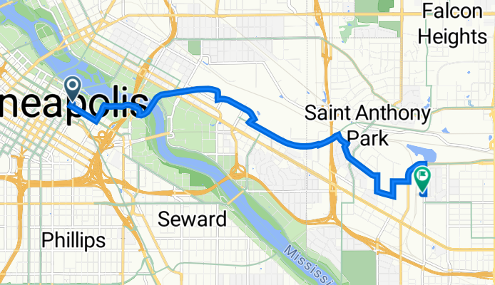
Routenvorlage
Minneapolis nach Falcon Heights
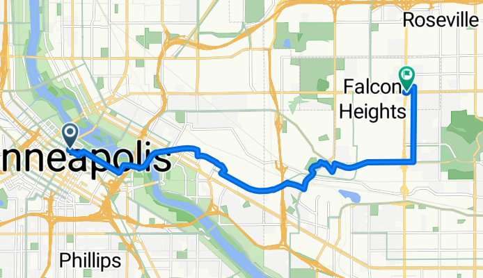
- 43 min
- Dauer
- 11,9 km
- Distanz
- 72 m
- Aufstieg
- 39 m
- Abstieg
- 16,7 km/h
- Ø-Tempo
- 291 m
- Max. Höhe
Auf geht’s zu einer entspannten Radtour von Minneapolis nach Falcon Heights! Die Strecke ist rund 12 Kilometer lang und führt dich überwiegend über schöne, asphaltierte Radwege (ca. 63 % Radweg-Anteil – Luxus!). Du brauchst dir also keine Sorgen um viel Verkehr machen. Die Route ist recht flach mit einem moderaten Anstieg von etwa 72 Metern – das geht locker, auch wenn du nicht täglich im Sattel sitzt.
Du startest in Minneapolis, der coolen Metropole am Mississippi — bekannt für ihre lebendige Kunstszene, die vielen Parks und ihre berühmte Kettenbrücke. Richtung Osten strampelst du dann nach Falcon Heights, einer grünen, gemütlichen Stadt im Großraum Saint Paul, Heimat des berühmten Minnesota State Fair. Es lohnt sich also, ein Päuschen einzuplanen!
Die meiste Zeit rollst du auf glattem Asphalt, ein kleiner Teil ist betoniert oder fehlt als Oberflächeninfo – aber das sollte kein Problem sein. Alles in allem eine schöne Tour für Einsteiger und Genussradler!
Community
Top-Mitglieder in dieser Region


Von unserer Community
Die besten Fahrradrouten von Minneapolis nach Falcon Heights
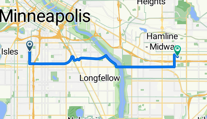
B2B00212 55404>55104 viaMidtownGreenway/wRiver/LakeSt.Marshall/Hamline
Fahrradtour in Minneapolis, Minnesota, Vereinigte Staaten
- 12,4 km
- Distanz
- 47 m
- Aufstieg
- 35 m
- Abstieg

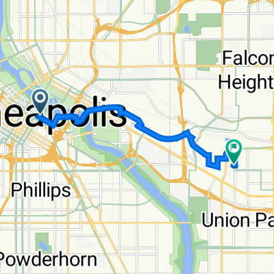
B2B00302 55405>55108 via Greenway, Raymond Ave
Fahrradtour in Minneapolis, Minnesota, Vereinigte Staaten
- 15,3 km
- Distanz
- 45 m
- Aufstieg
- 40 m
- Abstieg

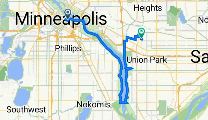
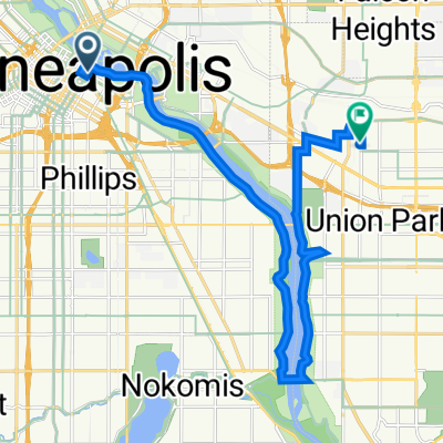
B2B00160 55407>55108 via 32nd, marshall, otis, pelham, and hewitt
Fahrradtour in Minneapolis, Minnesota, Vereinigte Staaten
- 11 km
- Distanz
- 97 m
- Aufstieg
- 76 m
- Abstieg

B2B00551 55405>55108 via Park Av, University Av, Como Av
Fahrradtour in Minneapolis, Minnesota, Vereinigte Staaten
- 15,6 km
- Distanz
- 94 m
- Aufstieg
- 79 m
- Abstieg

B2B00905 55411>55108 via Plymouth Av, University Av, Transitway
Fahrradtour in Minneapolis, Minnesota, Vereinigte Staaten
- 13,4 km
- Distanz
- 105 m
- Aufstieg
- 75 m
- Abstieg

B2B00527 55409>55108 via Park Av, University Av, Transitway
Fahrradtour in Minneapolis, Minnesota, Vereinigte Staaten
- 15 km
- Distanz
- 94 m
- Aufstieg
- 58 m
- Abstieg

B2B00571 55404 < 55114 via Pleasant, Greenway, River Rd, Phelam
Fahrradtour in Minneapolis, Minnesota, Vereinigte Staaten
- 10,9 km
- Distanz
- 41 m
- Aufstieg
- 36 m
- Abstieg

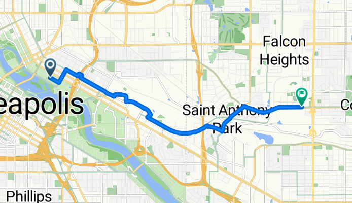
B2B00369 55401 > 55108 via Stonearch, University, Transitway, Energy Park Dr
Fahrradtour in Minneapolis, Minnesota, Vereinigte Staaten
- 11,2 km
- Distanz
- 76 m
- Aufstieg
- 45 m
- Abstieg

B2B00645 55406 > 55114 via Franklin Ave, University Ave
Fahrradtour in Minneapolis, Minnesota, Vereinigte Staaten
- 2,6 km
- Distanz
- 51 m
- Aufstieg
- 33 m
- Abstieg
Vestibule shop best route
Fahrradtour in Minneapolis, Minnesota, Vereinigte Staaten
- 19,1 km
- Distanz
- 217 m
- Aufstieg
- 196 m
- Abstieg
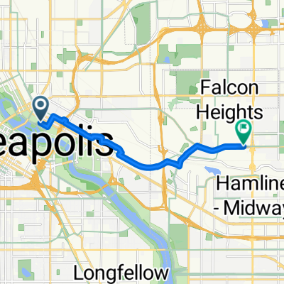
From Minneapolis to Saint Paul
Fahrradtour in Minneapolis, Minnesota, Vereinigte Staaten
- 8,3 km
- Distanz
- 53 m
- Aufstieg
- 23 m
- Abstieg
205 Park Ave, Minneapolis to 755 Prior Ave N, Saint Paul
Fahrradtour in Minneapolis, Minnesota, Vereinigte Staaten
- 8,9 km
- Distanz
- 61 m
- Aufstieg
- 41 m
- Abstieg
Mehr Routen entdecken
 B2B00905 55411>55108 via Plymouth Av, University Av, Transitway
- Distanz
- 13,4 km
- Aufstieg
- 105 m
- Abstieg
- 75 m
- Standort
- Minneapolis, Minnesota, Vereinigte Staaten
 B2B00527 55409>55108 via Park Av, University Av, Transitway
- Distanz
- 15 km
- Aufstieg
- 94 m
- Abstieg
- 58 m
- Standort
- Minneapolis, Minnesota, Vereinigte Staaten
 B2B00571 55404 < 55114 via Pleasant, Greenway, River Rd, Phelam
- Distanz
- 10,9 km
- Aufstieg
- 41 m
- Abstieg
- 36 m
- Standort
- Minneapolis, Minnesota, Vereinigte Staaten
 B2B00369 55401 > 55108 via Stonearch, University, Transitway, Energy Park Dr
- Distanz
- 11,2 km
- Aufstieg
- 76 m
- Abstieg
- 45 m
- Standort
- Minneapolis, Minnesota, Vereinigte Staaten
 B2B00645 55406 > 55114 via Franklin Ave, University Ave
- Distanz
- 2,6 km
- Aufstieg
- 51 m
- Abstieg
- 33 m
- Standort
- Minneapolis, Minnesota, Vereinigte Staaten
 Vestibule shop best route
- Distanz
- 19,1 km
- Aufstieg
- 217 m
- Abstieg
- 196 m
- Standort
- Minneapolis, Minnesota, Vereinigte Staaten
 From Minneapolis to Saint Paul
- Distanz
- 8,3 km
- Aufstieg
- 53 m
- Abstieg
- 23 m
- Standort
- Minneapolis, Minnesota, Vereinigte Staaten
 205 Park Ave, Minneapolis to 755 Prior Ave N, Saint Paul
- Distanz
- 8,9 km
- Aufstieg
- 61 m
- Abstieg
- 41 m
- Standort
- Minneapolis, Minnesota, Vereinigte Staaten
Routen von Minneapolis
Tagesausflug mit dem Fahrrad von
Minneapolis nach Mendota Heights
Tagesausflug mit dem Fahrrad von
Minneapolis nach Saint Paul
Mit dem Fahrrad von
Minneapolis nach Lauderdale
Mit dem Fahrrad von
Minneapolis nach Saint Anthony