
Tagesausflug mit dem Fahrrad von Minneapolis nach Saint Paul
Erstelle deine eigene Route auf der Grundlage unserer Vorlage oder lass dich inspirieren, wie unsere Nutzer am liebsten von Minneapolis nach Saint Paul radeln.
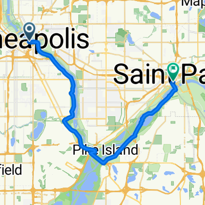
Routenvorlage
Minneapolis nach Saint Paul

- 1 h 27 min
- Dauer
- 25,5 km
- Distanz
- 201 m
- Aufstieg
- 227 m
- Abstieg
- 17,6 km/h
- Ø-Tempo
- 259 m
- Max. Höhe
Schnapp dir dein Rad und erlebe eine tolle Tour von Minneapolis nach Saint Paul! Auf rund 25 Kilometern führt dich diese fast durchgehend asphaltierte und perfekt ausgebaute Strecke (98% Radweg!) quer durch das grüne Herz der Twin Cities. Genieße sanftes Auf und Ab mit etwa 200 Metern Anstieg – so bleibt’s sportlich, ohne zu übertreiben.
Start ist in Minneapolis, einer pulsierenden Stadt, die für ihre lebendige Kunstszene, unzählige Seen und ihre Fahrradfreundlichkeit bekannt ist. Von dort aus rollst du entspannt Richtung Osten, meist abseits vom Autoverkehr, hinein nach Saint Paul, die charmante Schwesterstadt am Mississippi mit wunderschönen viktorianischen Gebäuden und dem beeindruckenden Capitol.
Egal ob Genießer oder Pendler: Diese Strecke macht einfach Spaß – super glatt, wenig Stress und Natur satt!
Community
Top-Mitglieder in dieser Region


Von unserer Community
Die besten Fahrradrouten von Minneapolis nach Saint Paul

home ride
Fahrradtour in Minneapolis, Minnesota, Vereinigte Staaten
- 16,6 km
- Distanz
- 115 m
- Aufstieg
- 149 m
- Abstieg

Mississippi River Trail
Fahrradtour in Minneapolis, Minnesota, Vereinigte Staaten
- 47,3 km
- Distanz
- 247 m
- Aufstieg
- 245 m
- Abstieg

B2B00309 55401>55101 via University Av, Transitway, Como Ave
Fahrradtour in Minneapolis, Minnesota, Vereinigte Staaten
- 17,7 km
- Distanz
- 106 m
- Aufstieg
- 105 m
- Abstieg

B2B00865 55405>55102 via Greenway, Summit Av
Fahrradtour in Minneapolis, Minnesota, Vereinigte Staaten
- 19,9 km
- Distanz
- 76 m
- Aufstieg
- 76 m
- Abstieg

B2B00204 55413>55102 via University & Como Ave
Fahrradtour in Minneapolis, Minnesota, Vereinigte Staaten
- 16,8 km
- Distanz
- 83 m
- Aufstieg
- 103 m
- Abstieg

St. Paul
Fahrradtour in Minneapolis, Minnesota, Vereinigte Staaten
- 26,2 km
- Distanz
- 168 m
- Aufstieg
- 172 m
- Abstieg

B2B 55413 > 55101 via East River Rd., Summit Ave.
Fahrradtour in Minneapolis, Minnesota, Vereinigte Staaten
- 19,2 km
- Distanz
- 126 m
- Aufstieg
- 134 m
- Abstieg

B2B00083 55403 > 55102 via Nicollet, Midtown Greenway, W. River Road, Lake/Marshall, Summit, Kellog Blvd., 7th St. W.
Fahrradtour in Minneapolis, Minnesota, Vereinigte Staaten
- 18,1 km
- Distanz
- 44 m
- Aufstieg
- 52 m
- Abstieg

B2B00762 55413>55101 via 8th St SE, Como Av
Fahrradtour in Minneapolis, Minnesota, Vereinigte Staaten
- 17,2 km
- Distanz
- 53 m
- Aufstieg
- 46 m
- Abstieg

B2B00267 55401>55101via Hiawatha Trl, Greenway and Marshall Ave
Fahrradtour in Minneapolis, Minnesota, Vereinigte Staaten
- 16,3 km
- Distanz
- 55 m
- Aufstieg
- 37 m
- Abstieg

B2B00761 55413>55102 via 8th Av SE, Como Av, Cedar St
Fahrradtour in Minneapolis, Minnesota, Vereinigte Staaten
- 17,6 km
- Distanz
- 51 m
- Aufstieg
- 61 m
- Abstieg

B2B00881 55407>55102 via Greenway, Summit Av
Fahrradtour in Minneapolis, Minnesota, Vereinigte Staaten
- 15,2 km
- Distanz
- 65 m
- Aufstieg
- 77 m
- Abstieg
Mehr Routen entdecken
 B2B00204 55413>55102 via University & Como Ave
- Distanz
- 16,8 km
- Aufstieg
- 83 m
- Abstieg
- 103 m
- Standort
- Minneapolis, Minnesota, Vereinigte Staaten
 St. Paul
- Distanz
- 26,2 km
- Aufstieg
- 168 m
- Abstieg
- 172 m
- Standort
- Minneapolis, Minnesota, Vereinigte Staaten
 B2B 55413 > 55101 via East River Rd., Summit Ave.
- Distanz
- 19,2 km
- Aufstieg
- 126 m
- Abstieg
- 134 m
- Standort
- Minneapolis, Minnesota, Vereinigte Staaten
 B2B00083 55403 > 55102 via Nicollet, Midtown Greenway, W. River Road, Lake/Marshall, Summit, Kellog Blvd., 7th St. W.
- Distanz
- 18,1 km
- Aufstieg
- 44 m
- Abstieg
- 52 m
- Standort
- Minneapolis, Minnesota, Vereinigte Staaten
 B2B00762 55413>55101 via 8th St SE, Como Av
- Distanz
- 17,2 km
- Aufstieg
- 53 m
- Abstieg
- 46 m
- Standort
- Minneapolis, Minnesota, Vereinigte Staaten
 B2B00267 55401>55101via Hiawatha Trl, Greenway and Marshall Ave
- Distanz
- 16,3 km
- Aufstieg
- 55 m
- Abstieg
- 37 m
- Standort
- Minneapolis, Minnesota, Vereinigte Staaten
 B2B00761 55413>55102 via 8th Av SE, Como Av, Cedar St
- Distanz
- 17,6 km
- Aufstieg
- 51 m
- Abstieg
- 61 m
- Standort
- Minneapolis, Minnesota, Vereinigte Staaten
 B2B00881 55407>55102 via Greenway, Summit Av
- Distanz
- 15,2 km
- Aufstieg
- 65 m
- Abstieg
- 77 m
- Standort
- Minneapolis, Minnesota, Vereinigte Staaten
Routen von Minneapolis
Tagesausflug mit dem Fahrrad von
Minneapolis nach Mendota Heights
Tagesausflug mit dem Fahrrad von
Minneapolis nach Richfield
Kurze Fahrt mit dem Fahrrad von
Minneapolis nach Saint Louis Park
Kurze Fahrt mit dem Fahrrad von
Minneapolis nach Saint Anthony