

02A-LakeUH-Yuc-JB-Rouse-AT
Eine Fahrradroute, die in Oviedo, Florida, United States of America beginnt.
Übersicht
Über diese Route
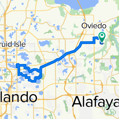
This is one of several routes that will take you to South Orlando, go east, then come back to AWB.
This route takes you from Oviedo Alafaya Woods subdivision to Lake Baldwin via the Cross Seminole Trail and Cady Way Trail. To get to the CST Trail, it goes from Alafaya Trail (SR 434) to Chapman where it intersects with CST at Aloma Road.
It doesn't quite get to Lake Baldwin. Instead, it stays on CWT and goes into a Baldwin neighborhood, which winds itself to Fashion Square Mall via a nice trail. From Fashion Square, it goes south along Crystal Lake Road, past Orlando Executive Airport, and under the 408 toll road to Lake Underhill Trail. At the end of LUT, it winds through residential areas and goes through DeMetree, LaCosta and Holquiest Parks. These are very scenic parks, especially LaCosta. It then takes Alder Street to the Oaxils 408 overpass, continues to Yucatan Neighborhood Park - another very nice park. Then it goes to Goldenrod Road, where it goes north to Colonial Drive. At Colonial, it jogs west about half a block and goes north on Yates Road, which is short but leads to Jay Blanchard Park. Now this is a very nice park that straddles the Little Econ River and is very scenic.
From Blanchard, it goes to Rouse Avenue, turns left (north) and intersects with University Blvd.
Cross University and go north to where Rouse makes a right turn. Use sidewalks to Alafaya Trail (SR 434). Head north on Alafaya Trail until you get to the RaceTrac at Alafaya Woods Blvd, then home.
- 3 h 49 min
- Dauer
- 60,3 km
- Distanz
- 290 m
- Aufstieg
- 287 m
- Abstieg
- 15,8 km/h
- Ø-Tempo
- 47 m
- Ø-Tempo

Routenqualität
Wegtypen und Untergründe entlang der Route
Wegtypen
Radweg
23 km
(38 %)
Straße
10,9 km
(18 %)
Untergründe
Befestigt
32,6 km
(54 %)
Unbefestigt
0,2 km
(<1 %)
Asphalt
21 km
(35 %)
Beton
6,4 km
(11 %)
Weiter mit Bikemap
Diese Radroute verwenden, bearbeiten oder herunterladen
Du möchtest 02A-LakeUH-Yuc-JB-Rouse-AT fahren oder sie für deine eigene Reise anpassen? Folgendes kannst du mit dieser Bikemap-Route machen:
Gratis Funktionen
- Speichere diese Route als Favorit oder in einer Sammlung
- Kopiere & plane deine eigene Version dieser Route
- Synchronisiere deine Route mit Garmin oder Wahoo
Premium-Funktionen
Kostenlose Testversion für 3 Tage oder einmalige Zahlung. Mehr über Bikemap Premium.
- Navigiere diese Route auf iOS & Android
- Exportiere eine GPX / KML-Datei dieser Route
- Erstelle deinen individuellen Ausdruck (Jetzt kostenlos ausprobieren)
- Lade diese Route für die Offline-Navigation herunter
Entdecke weitere Premium-Funktionen.
Bikemap Premium aktivierenVon unserer Community
Oviedo: Andere beliebte Routen, die hier beginnen
 Seminole Sunday Drive
- Distanz
- 69,5 km
- Aufstieg
- 101 m
- Abstieg
- 98 m
- Standort
- Oviedo, Florida, USA
 03-Sect8-SCP-Torcaso-Dys
- Distanz
- 48,4 km
- Aufstieg
- 195 m
- Abstieg
- 195 m
- Standort
- Oviedo, Florida, USA
 35-LBald-REI-Interlachen-CWT-CST-McK
- Distanz
- 49,6 km
- Aufstieg
- 25 m
- Abstieg
- 46 m
- Standort
- Oviedo, Florida, USA
 16C-Barnett-WG-RTrac-105
- Distanz
- 61,5 km
- Aufstieg
- 333 m
- Abstieg
- 313 m
- Standort
- Oviedo, Florida, USA
 36-Hme-Neuro-Kewan-RR
- Distanz
- 50 km
- Aufstieg
- 234 m
- Abstieg
- 236 m
- Standort
- Oviedo, Florida, USA
 11-LeeRT-SanLPark-Costco
- Distanz
- 46,6 km
- Aufstieg
- 255 m
- Abstieg
- 245 m
- Standort
- Oviedo, Florida, USA
 winter springs to Winter Park
- Distanz
- 24,7 km
- Aufstieg
- 96 m
- Abstieg
- 76 m
- Standort
- Oviedo, Florida, USA
 38A-SCP-LM-LOB-HGNP-McD
- Distanz
- 44,9 km
- Aufstieg
- 227 m
- Abstieg
- 234 m
- Standort
- Oviedo, Florida, USA
In der App öffnen