

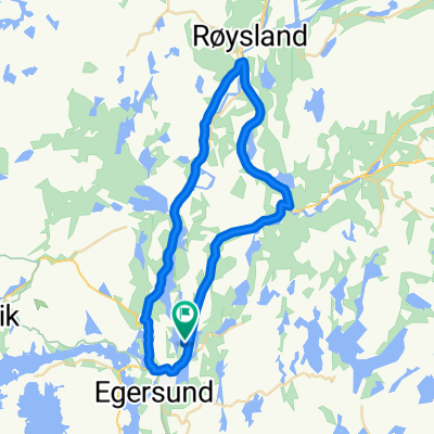
92. Egersund to Kvinesdal
Eine Fahrradroute, die in Egersund, Rogaland, Norwegen beginnt.
Übersicht
Über diese Route
- -:--
- Dauer
- 104,5 km
- Distanz
- 2.800 m
- Aufstieg
- 2.613 m
- Abstieg
- ---
- Ø-Tempo
- 281 m
- Max. Höhe

Routenqualität
Wegtypen und Untergründe entlang der Route
Wegtypen
Radweg
10,5 km
(10 %)
Straße
9,4 km
(9 %)
Untergründe
Befestigt
81,5 km
(78 %)
Unbefestigt
1 km
(1 %)
Asphalt
80,5 km
(77 %)
Befestigt (undefiniert)
1 km
(1 %)
Highlights der Route
POIs entlang der Route
Unterkunft nach 0 km
Grand Hotell Egersund AS
Interessanter Ort nach 0 km
Eigersund kyrkje
Interessanter Ort nach 21,4 km
Nesvåghålo Great trip to Nesvåghålo. Well marked, and it will surely get better. Not long walk to walk, about 15-20 min from the road, nearest buildings. Must go all the way down to the seafront before you see the hole. It looks bigger in the pictures than in reality. Great and see how nature creates its works of art and sights. Should be completely dry weather, as it can possibly get a little slippery in wet weather. Beautiful with sun and blue sky.
Interessanter Ort nach 27,9 km
Rekefjordtunnelen Length: 85m Lighting: No lighting. Comments : No lighting but a short straight easy tunnel.
Interessanter Ort nach 28,2 km
Lille Presteskjær Lighthouse

Interessanter Ort nach 39,2 km
Jøssinghavn II Length: 245m Lighting: None Comments : Narrow no lighting and bends. Uphill towards Hauge. Plenty of refuge space to pull over to let traffic pass. Alternative route : Old road runs parallel and is a series of short tunnels and galleries hacked into the side of the cliff and is a much nicer option for cycling - it has good views outwards. Downhill entrance of this is next to main tunnel entrance, uphill side joins main tunnel for the last 20m or so.
Interessanter Ort nach 39,2 km
Tunnelstuo Scenic spot
Interessanter Ort nach 40,1 km
Trallebanen
Interessanter Ort nach 40,2 km
Nedre Helleren Kraftverk
Interessanter Ort nach 40,4 km
Helleren folk museum
Interessanter Ort nach 40,5 km
Jøssinghavn I Length: 64m Lighting: None
Trinkwasser nach 51,8 km
Joker
Interessanter Ort nach 51,9 km
Åna-Sira kirke
Interessanter Ort nach 78,6 km
Gaupåstunnelen Length: 309m Lighting: Yes Comments : Tunnel curving and sloping downwards from East to West. There was heavy and fast traffic on the road on a Saturday lunchtime. I would not have wanted to cycle this tunnel uphill West to East! There is an unpaved cycle path going around it, so it can easily be avoided. Alternative route : This tunnel can be avoided if you follow the cycle route 1 signs. There is a marked route for cyclists around, but a lot of blogs complain that this is in bad shape! I could see from the road that it did not have asphalt.

Interessanter Ort nach 80,8 km
Fosselandstunnelen Length: 612m Lighting: yes Comments : Tunnel and E39 further on banned for cyclists. Alternative route : Go around the tunnel via the old road. It is a bit of a detour, but nice nature. Bumpy asphalt. Little or no traffic

Interessanter Ort nach 84,5 km
Svindlandstunnelen Length: 350m Lighting: Yes Comments : This part of E39 is banned to cyclists. Alternative route : You have to take the old road around the tunnel. It is a bit of a detour through Feda town and up to Liknes Kvindal, but nice nature.

Interessanter Ort nach 85,2 km
Lindlandtunnelen Length: 250m Lighting: Yes Comments : This part of E39 banned to cyclists. Alternative route : You take the road around the tunnel.
Trinkwasser nach 87,1 km
Coop

Interessanter Ort nach 87,6 km
Fedaheitunnelen Length: 1434m Lighting: Yes Comments : This part of E39 banned to cyclists Alternative route : The old road goes around through Feda town and Liknes.
Unterkunft nach 104,5 km
Utsikten Hotell Kvinesdal
Weiter mit Bikemap
Diese Radroute verwenden, bearbeiten oder herunterladen
Du möchtest 92. Egersund to Kvinesdal fahren oder sie für deine eigene Reise anpassen? Folgendes kannst du mit dieser Bikemap-Route machen:
Gratis Funktionen
- Speichere diese Route als Favorit oder in einer Sammlung
- Kopiere & plane deine eigene Version dieser Route
- Teile sie in Etappen ein, um eine mehrtägige Tour zu erstellen
- Synchronisiere deine Route mit Garmin oder Wahoo
Premium-Funktionen
Kostenlose Testversion für 3 Tage oder einmalige Zahlung. Mehr über Bikemap Premium.
- Navigiere diese Route auf iOS & Android
- Exportiere eine GPX / KML-Datei dieser Route
- Erstelle deinen individuellen Ausdruck (Jetzt kostenlos ausprobieren)
- Lade diese Route für die Offline-Navigation herunter
Entdecke weitere Premium-Funktionen.
Bikemap Premium aktivierenVon unserer Community
Egersund: Andere beliebte Routen, die hier beginnen
 Lagtempo-Dalane SK
- Distanz
- 33,4 km
- Aufstieg
- 245 m
- Abstieg
- 245 m
- Standort
- Egersund, Rogaland, Norwegen
 Johan Feyers gate 4 to Primær Fylkesveg 44 5
- Distanz
- 16,1 km
- Aufstieg
- 206 m
- Abstieg
- 80 m
- Standort
- Egersund, Rogaland, Norwegen
 Egersund - Bryne
- Distanz
- 63,1 km
- Aufstieg
- 583 m
- Abstieg
- 570 m
- Standort
- Egersund, Rogaland, Norwegen
 Kristiansand-Stavanger - del 4 (Egersund-Stavanger)
- Distanz
- 109,5 km
- Aufstieg
- 601 m
- Abstieg
- 598 m
- Standort
- Egersund, Rogaland, Norwegen
 GEObike Egersund- Hellvik- Egersund
- Distanz
- 24,4 km
- Aufstieg
- 225 m
- Abstieg
- 229 m
- Standort
- Egersund, Rogaland, Norwegen
 Tour des Fjords Lap #4
- Distanz
- 149,1 km
- Aufstieg
- 904 m
- Abstieg
- 898 m
- Standort
- Egersund, Rogaland, Norwegen
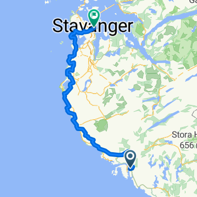
 Egersund - Stavanger
- Distanz
- 95,6 km
- Aufstieg
- 357 m
- Abstieg
- 348 m
- Standort
- Egersund, Rogaland, Norwegen
 Nordsjøruta vest: Egersund - Stavanger
- Distanz
- 113,3 km
- Aufstieg
- 785 m
- Abstieg
- 777 m
- Standort
- Egersund, Rogaland, Norwegen
In der App öffnen