

L06KremsTulln
Eine Fahrradroute, die in Krems an der Donau, Niederösterreich, Österreich beginnt.
Übersicht
Über diese Route
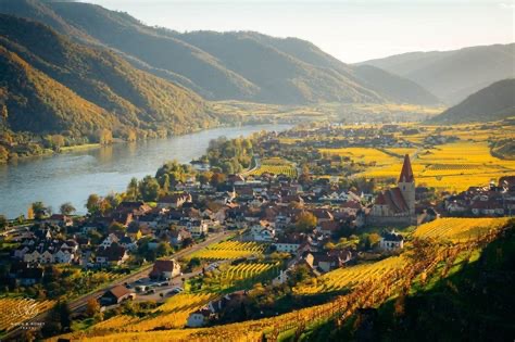
From medieval city to a city of gardens and art / Today’s tour takes you along the north and south bank of the Danube and out of the Wachau and its countryside shaped by human hand. You start in Krems along the Danube, a charming center of commerce and culture, and pedal along the Danube Bike Path to Tulln, a Danube town known for its gardens and art. Altenwörth and Zwentendorf are among the towns you pass through before arriving at your destination on the south bank of the river. / IMPORTANT NOTICE: / From February 2020 until the end of 2021, the Danube Cycle Trail will be diverted in the Höhe Ringstraße area of Krems, due to necessary pipeline works. In addition, the Treppelweg along the Danube is undergoing renovation works until the end of June. Please follow the diversion signposts in the Krems city area. / Due construction works, the entire section between Krems and Tulln on the north bank will be closed from April 2020 to December 2021. We kindly request all cyclists travelling from Krems to Tulln or vice versa to use the cycle trail on the south bank. The diversion is signposted. / Krems an der Donau – AltenWorth (pritok Traisen) prečkamo reko na desni breg - Zwentendorf an der Donau – Kleinschonbichl - Pischelsdorf - Langenschonbichl - Tulln ob Donavi (41 km, 20 m)
- -:--
- Dauer
- 42,6 km
- Distanz
- 87 m
- Aufstieg
- 108 m
- Abstieg
- ---
- Ø-Tempo
- 203 m
- Max. Höhe

Routenqualität
Wegtypen und Untergründe entlang der Route
Wegtypen
Forst- / Feldweg
25,7 km
(60 %)
Ruhige Straße
6,8 km
(16 %)
Untergründe
Befestigt
40,2 km
(94 %)
Unbefestigt
2,4 km
(6 %)
Asphalt
40,2 km
(94 %)
Unbefestigt (undefiniert)
2,4 km
(6 %)
Weiter mit Bikemap
Diese Radroute verwenden, bearbeiten oder herunterladen
Du möchtest L06KremsTulln fahren oder sie für deine eigene Reise anpassen? Folgendes kannst du mit dieser Bikemap-Route machen:
Gratis Funktionen
- Speichere diese Route als Favorit oder in einer Sammlung
- Kopiere & plane deine eigene Version dieser Route
- Synchronisiere deine Route mit Garmin oder Wahoo
Premium-Funktionen
Kostenlose Testversion für 3 Tage oder einmalige Zahlung. Mehr über Bikemap Premium.
- Navigiere diese Route auf iOS & Android
- Exportiere eine GPX / KML-Datei dieser Route
- Erstelle deinen individuellen Ausdruck (Jetzt kostenlos ausprobieren)
- Lade diese Route für die Offline-Navigation herunter
Entdecke weitere Premium-Funktionen.
Bikemap Premium aktivierenVon unserer Community
Krems an der Donau: Andere beliebte Routen, die hier beginnen
 Krems to Spitz in Wachau
- Distanz
- 20,9 km
- Aufstieg
- 249 m
- Abstieg
- 218 m
- Standort
- Krems an der Donau, Niederösterreich, Österreich
 Krems - Dobrastausee
- Distanz
- 113,4 km
- Aufstieg
- 2.111 m
- Abstieg
- 2.031 m
- Standort
- Krems an der Donau, Niederösterreich, Österreich
 Krems-Fuglau
- Distanz
- 87,3 km
- Aufstieg
- 961 m
- Abstieg
- 961 m
- Standort
- Krems an der Donau, Niederösterreich, Österreich
 Krems-Altenwörth-Krems
- Distanz
- 43,2 km
- Aufstieg
- 51 m
- Abstieg
- 50 m
- Standort
- Krems an der Donau, Niederösterreich, Österreich
 Austria-Krems am der Donau (31.05.2021, 12:34:15)
- Distanz
- 78,4 km
- Aufstieg
- 765 m
- Abstieg
- 774 m
- Standort
- Krems an der Donau, Niederösterreich, Österreich
 Kleine Bergrunde
- Distanz
- 11,6 km
- Aufstieg
- 221 m
- Abstieg
- 221 m
- Standort
- Krems an der Donau, Niederösterreich, Österreich
 Krems - Weissenkirchen - Krems
- Distanz
- 34,6 km
- Aufstieg
- 141 m
- Abstieg
- 191 m
- Standort
- Krems an der Donau, Niederösterreich, Österreich
 Wachau túra harmadik nap
- Distanz
- 42,1 km
- Aufstieg
- 91 m
- Abstieg
- 111 m
- Standort
- Krems an der Donau, Niederösterreich, Österreich
In der App öffnen