

Von Gol bis Oslo
- 643 km
- 13.198 m
- 13.393 m
- Gol, Buskerud, Norwegen
Eine Fahrradroute, die in Gol, Buskerud, Norwegen beginnt.
Übersicht
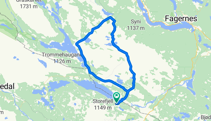
<span style="color: #000000; font-family: verdana, arial, helvetica, sans-serif; font-size: 11px; line-height: 16px; -webkit-border-horizontal-spacing: 4px; -webkit-border-vertical-spacing: 4px;">This route starts off at the intersection/crossroads at Fjellheimskrysset on highway Rv 51 (Gol - Leira).<br style="font: normal normal normal 11px/1.5em verdana, arial, helvetica, sans-serif; color: #000000; line-height: 0.8em;" /><br style="font: normal normal normal 11px/1.5em verdana, arial, helvetica, sans-serif; color: #000000; line-height: 0.8em;" />Follow the Golsfjellveien past the crossroads to Kamben, Ørterstølen and further on to Oset Høyfjellshotell. Continue towards the Tislei dam, cross it, and follow the road up to the crossroads at Buastølen.<br style="font: normal normal normal 11px/1.5em verdana, arial, helvetica, sans-serif; color: #000000; line-height: 0.8em;" /><br style="font: normal normal normal 11px/1.5em verdana, arial, helvetica, sans-serif; color: #000000; line-height: 0.8em;" /> Keep going straight past the different summer farmsuntil you get to Gomobu, which is the first obligatory waffle stop on the route. <br style="font: normal normal normal 11px/1.5em verdana, arial, helvetica, sans-serif; color: #000000; line-height: 0.8em;" /><br style="font: normal normal normal 11px/1.5em verdana, arial, helvetica, sans-serif; color: #000000; line-height: 0.8em;" />From Gomobu the road is steep downhill until you get on to the Panoramavegen (Panorama road) between Hemsedal and Valdres. <br style="font: normal normal normal 11px/1.5em verdana, arial, helvetica, sans-serif; color: #000000; line-height: 0.8em;" /><br style="font: normal normal normal 11px/1.5em verdana, arial, helvetica, sans-serif; color: #000000; line-height: 0.8em;" />On the Panoramavegen you can choose if you want the shorter route by turning left and going straight to Nøsen, where they make great waffles too, or if you want to go right and follow the signs to Trollhovd.<br style="font: normal normal normal 11px/1.5em verdana, arial, helvetica, sans-serif; color: #000000; line-height: 0.8em;" /><br style="font: normal normal normal 11px/1.5em verdana, arial, helvetica, sans-serif; color: #000000; line-height: 0.8em;" />From Trollhovd the route is downhill past Grønsetnabben og Svenskefjorden. Go straight ahead (do not cross the bridge on the right!) and follow the road along the lake and back to Panoramavegen. <br style="font: normal normal normal 11px/1.5em verdana, arial, helvetica, sans-serif; color: #000000; line-height: 0.8em;" /><br style="font: normal normal normal 11px/1.5em verdana, arial, helvetica, sans-serif; color: #000000; line-height: 0.8em;" />Go right and stay on the main road past the Flyvass dam and further along the Tisleifjorden. Go on past Langestølen (shop) and back to Buasttølen. Go left, ride back to Oset and onwards to Fjellheimkrysset.</span>
Erstellt vor 14 Jahren
Routenqualität
Straße
24 km
47 %
Ruhige Straße
23,5 km
46 %
Unbefestigt
30,1 km
(59 %)
Schotter
30,1 km
59 %
Undefiniert
20,9 km
41 %
Weiter mit Bikemap
Du möchtest The Waffle Tour 2 CLONED FROM ROUTE 496988 fahren oder sie für deine eigene Reise anpassen? Folgendes kannst du mit dieser Bikemap-Route machen:
Kostenlose Testversion für 3 Tage oder einmalige Zahlung. Mehr über Bikemap Premium.
Entdecke weitere Premium-Funktionen.
Bikemap Premium aktivierenVon unserer Community
In der App öffnen


