
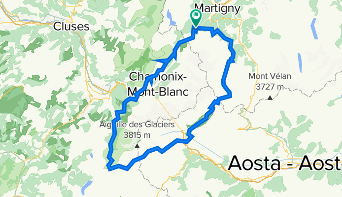
Hiking 120 Miles Alone on the Tour Du Mont Blanc Loop
Eine Fahrradroute, die in Martigny-Combe, Kanton Wallis, Schweiz beginnt.
Übersicht
Über diese Route
Die Tour du Mont Blanc ist eine 120 Meilen lange Runde, die um den Mont Blanc-Massiv führt und durch die Schweizer, Französischen und Italienischen Alpen verläuft. Jeder Abschnitt in den einzelnen Ländern hat seinen eigenen Charakter. Der Weg ist gut instand gehalten und mit bunten 'TMB'-Markierungen versehen. Auf diesem Weg findet man viele andere Leute, die aus unterschiedlichen Gründen wandern. Es ist meist unmöglich zu sagen, wie lange jemand schon unterwegs ist, weil der Weg eine Schleife ist ohne eigentlichen Start- oder Endpunkt. Man trifft Fernwanderer mit großen Rucksäcken, die die gesamte Runde machen, Tagess Wanderer, Gondel-Touristen, Trailrunner, Mountainbiker, Familien mit Hunden und Einheimische, die ihren Morgenspaziergang machen. Man passiert kleine Dörfer, die in den Bergen versteckt sind, und große lebhafte Städte voller Touristen. Der Weg ist gespickt mit Refugios und Campingplätzen, wo man essen, trinken und schlafen kann. Der Weg ist sicher, es gibt viele freundliche Menschen, die helfen, wenn nötig, und sehr gut ausgebaut, sodass jeder bei guter Gesundheit und mit eigenem Tempo die ganze Runde schaffen kann. Ich empfehle die Tour du Mont Blanc Runde allen, die ihre erste Wanderung von über 100 Meilen versuchen, wegen ihrer Schönheit, moderaten Schwierigkeit und geringem Risiko. Obwohl dies ein sehr populärer und viel begangener Weg in Europa ist, kann man doch alles noch ruhige Momente der Einsamkeit zwischen den Ortschaften und auf den Berpässen fern von Straßen oder Gondeln erleben.
- -:--
- Dauer
- 165,3 km
- Distanz
- 12.832 m
- Aufstieg
- 12.837 m
- Abstieg
- ---
- Ø-Tempo
- 2.663 m
- Max. Höhe

Weiter mit Bikemap
Diese Radroute verwenden, bearbeiten oder herunterladen
Du möchtest Hiking 120 Miles Alone on the Tour Du Mont Blanc Loop fahren oder sie für deine eigene Reise anpassen? Folgendes kannst du mit dieser Bikemap-Route machen:
Gratis Funktionen
- Speichere diese Route als Favorit oder in einer Sammlung
- Kopiere & plane deine eigene Version dieser Route
- Teile sie in Etappen ein, um eine mehrtägige Tour zu erstellen
- Synchronisiere deine Route mit Garmin oder Wahoo
Premium-Funktionen
Kostenlose Testversion für 3 Tage oder einmalige Zahlung. Mehr über Bikemap Premium.
- Navigiere diese Route auf iOS & Android
- Exportiere eine GPX / KML-Datei dieser Route
- Erstelle deinen individuellen Ausdruck (Jetzt kostenlos ausprobieren)
- Lade diese Route für die Offline-Navigation herunter
Entdecke weitere Premium-Funktionen.
Bikemap Premium aktivierenVon unserer Community
Martigny-Combe: Andere beliebte Routen, die hier beginnen
 Champex and Val Ferret
- Distanz
- 62,9 km
- Aufstieg
- 1.722 m
- Abstieg
- 1.722 m
- Standort
- Martigny-Combe, Kanton Wallis, Schweiz
 2017 ALPS Etapa 7 - Le Grand St Bernanrd
- Distanz
- 108,8 km
- Aufstieg
- 2.888 m
- Abstieg
- 2.896 m
- Standort
- Martigny-Combe, Kanton Wallis, Schweiz
 VTT MONT BLANC Vllorcine Albertville
- Distanz
- 432,8 km
- Aufstieg
- 8.172 m
- Abstieg
- 8.462 m
- Standort
- Martigny-Combe, Kanton Wallis, Schweiz
 MontBlancTour5Tag
- Distanz
- 14 km
- Aufstieg
- 1.107 m
- Abstieg
- 935 m
- Standort
- Martigny-Combe, Kanton Wallis, Schweiz
 Trevor - Champex and Planche
- Distanz
- 51,3 km
- Aufstieg
- 1.740 m
- Abstieg
- 1.740 m
- Standort
- Martigny-Combe, Kanton Wallis, Schweiz
 Startup Route des Grandes Alpes
- Distanz
- 40 km
- Aufstieg
- 1.360 m
- Abstieg
- 834 m
- Standort
- Martigny-Combe, Kanton Wallis, Schweiz
 Trevor - Champex lac loop
- Distanz
- 42,5 km
- Aufstieg
- 1.099 m
- Abstieg
- 1.099 m
- Standort
- Martigny-Combe, Kanton Wallis, Schweiz
 Trevor Base Route
- Distanz
- 93,3 km
- Aufstieg
- 715 m
- Abstieg
- 715 m
- Standort
- Martigny-Combe, Kanton Wallis, Schweiz
In der App öffnen