

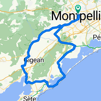
Loop from the Center of Montpellier
Eine Fahrradroute, die in Montpellier, Occitanie, Frankreich beginnt.
Übersicht
Über diese Route
Verlassen Sie die Stadt in Richtung D21 und biegen Sie nach der Unterführung der A9 rechts ab. Fahren Sie durch Lattes, Maurin und Puech Garou auf der D185. Folgen Sie dieser bis zur D613 und weiter zur D114. Überqueren Sie den Hügel nach Mireval und folgen Sie der D116 zurück durch Villeneuve-Les Maguelone. Dann arbeiten Sie sich auf dem gleichen Weg zurück nach Montpellier. Die Strecke ist etwas länger als angegeben, aber alles ist ziemlich flach, sodass etwa 2:15 Stunden ausreichen sollten.
- -:--
- Dauer
- 45,2 km
- Distanz
- 153 m
- Aufstieg
- 179 m
- Abstieg
- ---
- Ø-Tempo
- ---
- Max. Höhe
Routenqualität
Wegtypen und Untergründe entlang der Route
Wegtypen
Straße
15,4 km
(34 %)
Radweg
5,4 km
(12 %)
Untergründe
Befestigt
28,9 km
(64 %)
Asphalt
28,9 km
(64 %)
Undefiniert
16,3 km
(36 %)
Weiter mit Bikemap
Diese Radroute verwenden, bearbeiten oder herunterladen
Du möchtest Loop from the Center of Montpellier fahren oder sie für deine eigene Reise anpassen? Folgendes kannst du mit dieser Bikemap-Route machen:
Gratis Funktionen
- Speichere diese Route als Favorit oder in einer Sammlung
- Kopiere & plane deine eigene Version dieser Route
- Synchronisiere deine Route mit Garmin oder Wahoo
Premium-Funktionen
Kostenlose Testversion für 3 Tage oder einmalige Zahlung. Mehr über Bikemap Premium.
- Navigiere diese Route auf iOS & Android
- Exportiere eine GPX / KML-Datei dieser Route
- Erstelle deinen individuellen Ausdruck (Jetzt kostenlos ausprobieren)
- Lade diese Route für die Offline-Navigation herunter
Entdecke weitere Premium-Funktionen.
Bikemap Premium aktivierenVon unserer Community
Montpellier: Andere beliebte Routen, die hier beginnen
 Petit classique 77
- Distanz
- 77 km
- Aufstieg
- 540 m
- Abstieg
- 540 m
- Standort
- Montpellier, Occitanie, Frankreich
 OPT9_montpelliers_cerbere
- Distanz
- 233 km
- Aufstieg
- 217 m
- Abstieg
- 260 m
- Standort
- Montpellier, Occitanie, Frankreich
 MUC_Balade cyclo vers la Via Domicia "Cournonterral
- Distanz
- 42,7 km
- Aufstieg
- 160 m
- Abstieg
- 157 m
- Standort
- Montpellier, Occitanie, Frankreich
 LUNDI 11 NOVEMBRE : MUC Montpellier - RDV CREPS 8h30 90km Point café à Cournonterral par le club du Guidon Sportif Sétois
- Distanz
- 75 km
- Aufstieg
- 236 m
- Abstieg
- 236 m
- Standort
- Montpellier, Occitanie, Frankreich
 Tour de France 2009, Etappe 4 - 30,0 km
- Distanz
- 39 km
- Aufstieg
- 372 m
- Abstieg
- 367 m
- Standort
- Montpellier, Occitanie, Frankreich
 Vivons Vélo Rassemblement du 1er juillet 2017
- Distanz
- 27,1 km
- Aufstieg
- 39 m
- Abstieg
- 40 m
- Standort
- Montpellier, Occitanie, Frankreich
 Montpellier Nord - Pic Saint Loup
- Distanz
- 69,1 km
- Aufstieg
- 439 m
- Abstieg
- 439 m
- Standort
- Montpellier, Occitanie, Frankreich
 To_Barcelona
- Distanz
- 404,5 km
- Aufstieg
- 652 m
- Abstieg
- 659 m
- Standort
- Montpellier, Occitanie, Frankreich
In der App öffnen