

OSKIS_Ortoto_route_Part3
Eine Fahrradroute, die in Sveti Vlas, Burgas, Bulgarien beginnt.
Übersicht
Über diese Route
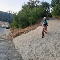
Combination of road trip and off-road, downhill bicycle tripOSKIS recommendations:- the road condition on mountains is quite complicated for cycling: 1st part with high climbing grade (from 20%) and full of rocks (slippery)- it needs a good level of bicycling experience and special equipment, like gloves, helmet, bag and enduro/downhill bike as well- use this route for bike tour w/ guide- usually it takes 3-4hrs for the whole trip- no shops or cafes over there, that's why it necessary to take with you: bottles of water, energy bars..- don't recommend to use it after the rain or on standard mountain bikes - the road condition will be very complicated on mountains: mostly climbing uphill w/ or on bike, during downhill - a lot of drops, stones on the ground and different turns, plus high speed (avr.: 12,5km/h, top: from 48km/h)
- -:--
- Dauer
- 19,2 km
- Distanz
- 509 m
- Aufstieg
- 483 m
- Abstieg
- ---
- Ø-Tempo
- 387 m
- Max. Höhe
Routenqualität
Wegtypen und Untergründe entlang der Route
Wegtypen
Forst- / Feldweg
8,9 km
(47 %)
Ruhige Straße
4,5 km
(23 %)
Untergründe
Befestigt
2,3 km
(12 %)
Unbefestigt
4,4 km
(23 %)
Schotter
4 km
(21 %)
Asphalt
1,9 km
(10 %)
Weiter mit Bikemap
Diese Radroute verwenden, bearbeiten oder herunterladen
Du möchtest OSKIS_Ortoto_route_Part3 fahren oder sie für deine eigene Reise anpassen? Folgendes kannst du mit dieser Bikemap-Route machen:
Gratis Funktionen
- Speichere diese Route als Favorit oder in einer Sammlung
- Kopiere & plane deine eigene Version dieser Route
- Synchronisiere deine Route mit Garmin oder Wahoo
Premium-Funktionen
Kostenlose Testversion für 3 Tage oder einmalige Zahlung. Mehr über Bikemap Premium.
- Navigiere diese Route auf iOS & Android
- Exportiere eine GPX / KML-Datei dieser Route
- Erstelle deinen individuellen Ausdruck (Jetzt kostenlos ausprobieren)
- Lade diese Route für die Offline-Navigation herunter
Entdecke weitere Premium-Funktionen.
Bikemap Premium aktivierenVon unserer Community
Sveti Vlas: Andere beliebte Routen, die hier beginnen
 Mountain pass
- Distanz
- 66,5 km
- Aufstieg
- 918 m
- Abstieg
- 915 m
- Standort
- Sveti Vlas, Burgas, Bulgarien
 elenite
- Distanz
- 16,4 km
- Aufstieg
- 545 m
- Abstieg
- 539 m
- Standort
- Sveti Vlas, Burgas, Bulgarien
 obikolka po selata
- Distanz
- 63,4 km
- Aufstieg
- 478 m
- Abstieg
- 476 m
- Standort
- Sveti Vlas, Burgas, Bulgarien
 Irakli
- Distanz
- 13,1 km
- Aufstieg
- 387 m
- Abstieg
- 463 m
- Standort
- Sveti Vlas, Burgas, Bulgarien
 Пat bez ime, Sveti Vlas to Пat bez ime, Sveti Vlas
- Distanz
- 24,8 km
- Aufstieg
- 617 m
- Abstieg
- 574 m
- Standort
- Sveti Vlas, Burgas, Bulgarien
 kula
kula- Distanz
- 6,6 km
- Aufstieg
- 401 m
- Abstieg
- 11 m
- Standort
- Sveti Vlas, Burgas, Bulgarien
 "Black Sea Route" Epic Tour 2025 - Day 7-Emona-Sarafovo (via St Iliya peak)
- Distanz
- 65,2 km
- Aufstieg
- 850 m
- Abstieg
- 999 m
- Standort
- Sveti Vlas, Burgas, Bulgarien
 "Black Sea Route" Epic Tour 2025 - Day 7-Emona-Sarafovo
- Distanz
- 61,6 km
- Aufstieg
- 523 m
- Abstieg
- 672 m
- Standort
- Sveti Vlas, Burgas, Bulgarien
In der App öffnen