

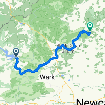
Tarmac alternative (NCN68) missing off road/ crossing fields at Clennell.
Eine Fahrradroute, die in Rochester, England, Vereinigtes Königreich beginnt.
Übersicht
Über diese Route
<!-- /* Style Definitions */ p.MsoNormal, li.MsoNormal, div.MsoNormal {mso-style-parent:""; margin:0cm; margin-bottom:.0001pt; mso-pagination:widow-orphan; font-size:12.0pt; font-family:"Times New Roman"; mso-fareast-font-family:"Times New Roman";} @page Section1 {size:612.0pt 792.0pt; margin:72.0pt 90.0pt 72.0pt 90.0pt; mso-header-margin:36.0pt; mso-footer-margin:36.0pt; mso-paper-source:0;} div.Section1 {page:Section1;} --> <span style="font-size: 12pt; font-family: "Times New Roman";">This is a tarmac alternative to the off road section of the Sustrans 'Pennine cycleway' NCN route 68 from Alwinton through Clennell. It's the same sort of distance.</span>
- -:--
- Dauer
- 3,9 km
- Distanz
- 106 m
- Aufstieg
- 10 m
- Abstieg
- ---
- Ø-Tempo
- 256 m
- Max. Höhe
Routenqualität
Wegtypen und Untergründe entlang der Route
Wegtypen
Straße
3,3 km
(83 %)
Ruhige Straße
0,6 km
(17 %)
Weiter mit Bikemap
Diese Radroute verwenden, bearbeiten oder herunterladen
Du möchtest Tarmac alternative (NCN68) missing off road/ crossing fields at Clennell. fahren oder sie für deine eigene Reise anpassen? Folgendes kannst du mit dieser Bikemap-Route machen:
Gratis Funktionen
- Speichere diese Route als Favorit oder in einer Sammlung
- Kopiere & plane deine eigene Version dieser Route
- Synchronisiere deine Route mit Garmin oder Wahoo
Premium-Funktionen
Kostenlose Testversion für 3 Tage oder einmalige Zahlung. Mehr über Bikemap Premium.
- Navigiere diese Route auf iOS & Android
- Exportiere eine GPX / KML-Datei dieser Route
- Erstelle deinen individuellen Ausdruck (Jetzt kostenlos ausprobieren)
- Lade diese Route für die Offline-Navigation herunter
Entdecke weitere Premium-Funktionen.
Bikemap Premium aktivierenVon unserer Community
Rochester: Andere beliebte Routen, die hier beginnen
 Rochester - Rothbury
- Distanz
- 67,3 km
- Aufstieg
- 838 m
- Abstieg
- 869 m
- Standort
- Rochester, England, Vereinigtes Königreich
 Kielder Water
- Distanz
- 48,4 km
- Aufstieg
- 444 m
- Abstieg
- 444 m
- Standort
- Rochester, England, Vereinigtes Königreich
 Tour de Wielka Brytania & Irlandia 2019 dzień 17
- Distanz
- 143,7 km
- Aufstieg
- 1.118 m
- Abstieg
- 1.248 m
- Standort
- Rochester, England, Vereinigtes Königreich
 Periple 11 / 28
- Distanz
- 167,7 km
- Aufstieg
- 1.250 m
- Abstieg
- 1.182 m
- Standort
- Rochester, England, Vereinigtes Königreich
 Tarmac alternative (NCN68) missing off road/ crossing fields at Clennell.
- Distanz
- 3,9 km
- Aufstieg
- 106 m
- Abstieg
- 10 m
- Standort
- Rochester, England, Vereinigtes Königreich
 Lew and Cal round Kielder
- Distanz
- 41,6 km
- Aufstieg
- 253 m
- Abstieg
- 253 m
- Standort
- Rochester, England, Vereinigtes Königreich
 Pt9 THE FINAL DAY
- Distanz
- 93,5 km
- Aufstieg
- 509 m
- Abstieg
- 675 m
- Standort
- Rochester, England, Vereinigtes Königreich
 Rochester Cycling
- Distanz
- 40,1 km
- Aufstieg
- 519 m
- Abstieg
- 522 m
- Standort
- Rochester, England, Vereinigtes Königreich
In der App öffnen