

Culham Trails Down to Lakeshore, Up from Port Credit
Eine Fahrradroute, die in Mississauga, Ontario, Kanada beginnt.
Übersicht
Über diese Route
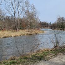
OVERVIEW: A great route with paved trails, however it will be unpaved throughout the Culham and Riverwood Trails. This route wll take you in the forest, along the lake, through the heart of the city, and more! Have fun!
ROUTE DESCRIPTION: This trail takes us from Celebration Square, Mississauga, down Riverwood to the Culham Trail. We will head straight on Mississauga Road all the way down to the Sheridan Trail, in which a series of trails will be taken down to the Waterfront Trail. This trail will take us to Port Credit, entering Jack Darling Memorial Park, Breuckner Rhododendron Gardens, ansd J.C. Saddington Park. Finally, we will head north briefly on Hurontario, then we will continue on the Cooksville Trail, where we will turn left on Burnhamthorpe trail and complete the loop.
- -:--
- Dauer
- 36,1 km
- Distanz
- 254 m
- Aufstieg
- 254 m
- Abstieg
- ---
- Ø-Tempo
- 161 m
- Max. Höhe

Routenqualität
Wegtypen und Untergründe entlang der Route
Wegtypen
Radweg
18,8 km
(52 %)
Ruhige Straße
8,7 km
(24 %)
Untergründe
Befestigt
27,4 km
(76 %)
Unbefestigt
2,5 km
(7 %)
Asphalt
26,3 km
(73 %)
Schotter
2,2 km
(6 %)
Weiter mit Bikemap
Diese Radroute verwenden, bearbeiten oder herunterladen
Du möchtest Culham Trails Down to Lakeshore, Up from Port Credit fahren oder sie für deine eigene Reise anpassen? Folgendes kannst du mit dieser Bikemap-Route machen:
Gratis Funktionen
- Speichere diese Route als Favorit oder in einer Sammlung
- Kopiere & plane deine eigene Version dieser Route
- Synchronisiere deine Route mit Garmin oder Wahoo
Premium-Funktionen
Kostenlose Testversion für 3 Tage oder einmalige Zahlung. Mehr über Bikemap Premium.
- Navigiere diese Route auf iOS & Android
- Exportiere eine GPX / KML-Datei dieser Route
- Erstelle deinen individuellen Ausdruck (Jetzt kostenlos ausprobieren)
- Lade diese Route für die Offline-Navigation herunter
Entdecke weitere Premium-Funktionen.
Bikemap Premium aktivierenVon unserer Community
Mississauga: Andere beliebte Routen, die hier beginnen
 Riverwood-SawmillValley-Culham Loop
- Distanz
- 10,1 km
- Aufstieg
- 90 m
- Abstieg
- 93 m
- Standort
- Mississauga, Ontario, Kanada
 Violet Road 4449, Mississauga to Violet Road 4449, Mississauga
- Distanz
- 11,9 km
- Aufstieg
- 83 m
- Abstieg
- 52 m
- Standort
- Mississauga, Ontario, Kanada
 MBRC-Campbellville via Hwy25 Speyside climb 52km
- Distanz
- 52,1 km
- Aufstieg
- 235 m
- Abstieg
- 121 m
- Standort
- Mississauga, Ontario, Kanada
 Warmup Churchill to Brittania and back
- Distanz
- 23,8 km
- Aufstieg
- 67 m
- Abstieg
- 64 m
- Standort
- Mississauga, Ontario, Kanada
 30k around the block
- Distanz
- 29,1 km
- Aufstieg
- 124 m
- Abstieg
- 127 m
- Standort
- Mississauga, Ontario, Kanada
 2013 Tour de Mississauga 100km
- Distanz
- 100,2 km
- Aufstieg
- 244 m
- Abstieg
- 243 m
- Standort
- Mississauga, Ontario, Kanada
 Erindale route...long
- Distanz
- 29,6 km
- Aufstieg
- 296 m
- Abstieg
- 289 m
- Standort
- Mississauga, Ontario, Kanada
 Windwood Drive 2881, Mississauga to Financial Drive 7987, Brampton
- Distanz
- 9,9 km
- Aufstieg
- 73 m
- Abstieg
- 78 m
- Standort
- Mississauga, Ontario, Kanada
In der App öffnen