

Mississauga to Burlington (Hamilton)
Eine Fahrradroute, die in Mississauga, Ontario, Canada beginnt.
Übersicht
Über diese Route
OVERVIEW: A round-trip that is entirely on trails and bike lanes, so there's no danger. The furthest we'll go is on the Burlington Skyway, just poking through Hamilton.
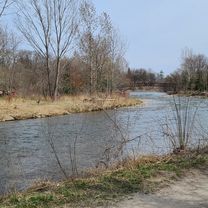
ROUTE DESCRIPTION: The route starts at Mississauga's Celebration Square by skipping Port Credit and goes to Erin Mills Pkwy via the Burnhamthorpe Trail. This road is taken down all the way to Lakeshore Rd (Watefront Trail). On your way to your destination, you'll pass through places like Lakeside Park, Tannery Park, Downtown Oakville, Coronation Park, Bronte's Parks, Downtown Burlington, Burloak Waterfront Park, Paletta Lakefront Park, Sioux Lookout Park, Spencer Smith Park, and finally, the Burlington Skyway where you can see the Toronto skyline. Afterwards, we will head back using the same route (or you can choose to not use the waterfront trail, which would decrease milage but increase time). Heading back is the same, however we will be able to visit Jack Darling Memorial Park, Brueckner Rhododendron Gardens, J.C. Saddington Park, Port Credit, JJ Plaus Park, and St Lawrence Park. A great place to relax after heading back to celebration square is Port Credit. Once we head out of the waterfront, we'll take Hurontario up to the Cooksville Creek Trail for a nice slow scenic ending to a long 100km journey.
LENGTH: This trip takes around 3 1/2 to 4 hours for more experienced cyclists, whereas 4 1/2 to 5 1/2 hours is more realistic. With stops to take pictures or visit parks, eating, relaxing, it may take 8 hours. I would leave at 8 AM and you'll be back at 4-5 PM AT MOST.
I hope you enjoy this route! Feel free to customize the second half of the trip, if you find heading back on the same trail is boring. Feedback is appreciated!
- -:--
- Dauer
- 100 km
- Distanz
- 595 m
- Aufstieg
- 595 m
- Abstieg
- ---
- Ø-Tempo
- 160 m
- Ø-Tempo

Routenqualität
Wegtypen und Untergründe entlang der Route
Wegtypen
Vielbefahrene Straße
35,8 km
(36 %)
Radweg
34,3 km
(34 %)
Untergründe
Befestigt
68,6 km
(69 %)
Unbefestigt
1,3 km
(1 %)
Asphalt
67 km
(67 %)
Beton
1,6 km
(2 %)
Weiter mit Bikemap
Diese Radroute verwenden, bearbeiten oder herunterladen
Du möchtest Mississauga to Burlington (Hamilton) fahren oder sie für deine eigene Reise anpassen? Folgendes kannst du mit dieser Bikemap-Route machen:
Gratis Funktionen
- Speichere diese Route als Favorit oder in einer Sammlung
- Kopiere & plane deine eigene Version dieser Route
- Synchronisiere deine Route mit Garmin oder Wahoo
Premium-Funktionen
Kostenlose Testversion für 3 Tage oder einmalige Zahlung. Mehr über Bikemap Premium.
- Navigiere diese Route auf iOS & Android
- Exportiere eine GPX / KML-Datei dieser Route
- Erstelle deinen individuellen Ausdruck (Jetzt kostenlos ausprobieren)
- Lade diese Route für die Offline-Navigation herunter
Entdecke weitere Premium-Funktionen.
Bikemap Premium aktivierenVon unserer Community
Mississauga: Andere beliebte Routen, die hier beginnen
 Day2_Missiisauga to Niagara Falls
- Distanz
- 119,8 km
- Aufstieg
- 385 m
- Abstieg
- 354 m
- Standort
- Mississauga, Ontario, Kanada
 Erindale route...long
- Distanz
- 29,6 km
- Aufstieg
- 296 m
- Abstieg
- 289 m
- Standort
- Mississauga, Ontario, Kanada
 Warmup Churchill to Brittania and back
- Distanz
- 23,8 km
- Aufstieg
- 67 m
- Abstieg
- 64 m
- Standort
- Mississauga, Ontario, Kanada
 MBRC-Campbellville via Hwy25 Speyside climb 52km
- Distanz
- 52,1 km
- Aufstieg
- 235 m
- Abstieg
- 121 m
- Standort
- Mississauga, Ontario, Kanada
 Riverwood-SawmillValley-Culham Loop
- Distanz
- 10,1 km
- Aufstieg
- 90 m
- Abstieg
- 93 m
- Standort
- Mississauga, Ontario, Kanada
 30k around the block
- Distanz
- 29,1 km
- Aufstieg
- 124 m
- Abstieg
- 127 m
- Standort
- Mississauga, Ontario, Kanada
 Violet Road 4449, Mississauga to Violet Road 4449, Mississauga
- Distanz
- 11,9 km
- Aufstieg
- 83 m
- Abstieg
- 52 m
- Standort
- Mississauga, Ontario, Kanada
 belfountain ride
- Distanz
- 74 km
- Aufstieg
- 405 m
- Abstieg
- 405 m
- Standort
- Mississauga, Ontario, Kanada
In der App öffnen